


1 / 7


Mentioned in this post
4.5/512 reviews | Hiking
Hong Kong
Details
Show more
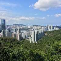
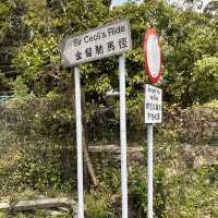
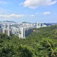
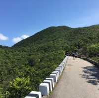
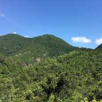
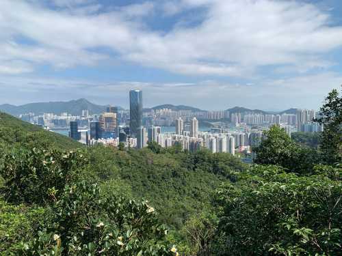
Difficulty: ⭐️ Mount Parker is a mountain in the Eastern District of Hong Kong Island, Hong Kong. It is the second highest peak on Hong Kong Island, with an altitude of 532 meters. Mount Parker has two peaks, the northeast and southwest. The northeast peak is where the radar station is located, 518 meters high and accessible by a cement road; the triangulation column with a height of 532 meters is located on the southwest peak behind it. Altitude: 532 Suggested route: Quarry Bay MTR Station > Mount Parker Road > Mount Parker > Hong Pak Country Trail > Tai Koo MTR Station (about 9.0 km)
Alice.W
Popular Trip Moments
Hidden Stories HK🌿 | Hong Kong Disneyland Fairy Tale Journey Must-Visit Spots | A Harbour Transformed: Whimsical Giants Grace Victoria Harbour | Recommended shopping mall-limited activities for family day trips | 🦞The most affordable buffet in Hong Kong🥰 All-you-can-eat lobster, sea urchin, and wagyu beef | Hong Kong.. | High-quality Japanese Izakaya | Old airport themed creative drinks | Hong Kong Hits: Monster Buildings, Sky-High Views & Epic Local Eats 😍 | Lounge Indulgence✨ | A Harbour's Duality | A Spectacle Afloat: Victoria Harbour’s Pop Culture Procession | Chaozhou cold oyster seafood is very satisfying 🦪 | A delicious ramen shop in Sham Shui Po! Rich broth and attentive service! | Central's high-altitude steakhouse with stunning dinner views | Exclusive in Hong Kong! A must-visit design market! | Daily life at the airport under the glass windows | Creative Hong Kong under blue sky and white clouds | [Hong Kong] A photogenic hotel perfect for anniversaries🇭🇰 | [Exotic atmosphere in Tsim Sha Tsui 🇱🇧Enjoy Lebanese cuisine while surrounded by flowers] | Labubu cruises to Hong Kong Victoria Harbour❗️Don't miss the Victoria Harbour Grand Parade❗️ | 📍𝒉𝒐𝒍𝒍𝒚𝒘𝒐𝒐𝒅 𝒓𝒐𝒂𝒅 - 𝒉𝒐𝒏𝒈 𝒌𝒐𝒏𝒈 | I Love Mentaiko at Grill Manten-Boshi | Guangzhou/Shenzhen to Hong Kong and Macau, point-to-point transfers! Direct border crossing | Faraway Lakeside Holiday Chill Time: A Historical Tour of Tai O | Japanese Omurice with Starry Sky 🍚 | Affordable and Scenic Hotel in Hong Kong | Recommended Thai restaurants in Mong Kok 🍽️
Recommended Attractions at Popular Destinations
Popular Attractions in Paris | Popular Attractions in Walt Disney World Resort | Popular Attractions in Bangkok | Popular Attractions in Barcelona | Popular Attractions in Kuala Lumpur | Popular Attractions in Chefchaouene | Popular Attractions in Singapore | Popular Attractions in Beijing | Popular Attractions in Osaka | Popular Attractions in Las Vegas | Popular Attractions in Melbourne | Popular Attractions in Dubai | Popular Attractions in Bali | Popular Attractions in Iguazu National Park(Argentina) | Popular Attractions in London | Popular Attractions in Shanghai | Popular Attractions in Sydney | Popular Attractions in West Lake | Popular Attractions in New York | Popular Attractions in Tokyo | Popular Attractions in Rome | Popular Attractions in Kyoto | Popular Attractions in Los Angeles | Popular Attractions in Phuket | Popular Attractions in Zanzibar Island | Popular Attractions in Madrid | Popular Attractions in Chengdu | Popular Attractions in Florence | Popular Attractions in Istanbul | Popular Attractions in Jungfrau Region
Popular Attractions
Pavilion of High Mountain and Flowing Water | Red Gate Palace | House of the Xue Family | Cuihua Mountain·Qinling Zhongnanshan Unesco Global Geopark | Wolong Bridge | Wangxian Bridge | Huaqing Palace | Emperor Qinshihuang's Mausoleum Site Museum | Huajue Lane, the Great Mosque | Shaanxi History Museum | Qinglong Temple | West Park | Puji Temple | Putuoshan Duobao Tower | Yang Guan | Yangshan Stone Buddha | Cangshan Mountain | Butterfly Spring Scenic Area | Sik Sik Yuen Wong Tai Sin Temple | Shixin Peak | Colonial Theatre Laconia | Fort Beauregard Veteran's Memorial Park | Hanuman mandir | Iskra | Eyre Reserve | Hanuman Mandir | Boothferry Golf Club | Silver Sage Golf Course | Golf364
Popular Restaurants in Hong Kong
MING COURT | Lamma Rainbow Seafood Restaurant | Lai Ching Heen | Tin Lung Heen | Tosca di Angelo | Aqua | Yung Kee Restaurant | Luk Yu Tea House | Spring Moon | Kau Kee Restaurant | 8½ Otto e Mezzo BOMBANA | T’ANG COURT | Tsui Hang Village Tsimshatsui | SUN HANG YUEN | Chee Kei | One Harbour Road | Tak Fat Beef Ball | Sky726 | Hu tong | Shang Palace | LUNG KING HEEN | TASTY CONGEE & NOODLE WANTUN SHOP (IFC Branch) | Paper Moon | The Verandah | The Chairman | Ah Yat Harbour View Restaurant | Hing Kee Restaurant | Yat Tung Heen | Loaf On Cuisine | Sing Heung Yuen
Popular Ranked Lists
Top 10 Best Things to Do in Incheon | Popular Luxury Hotels in Khomas | Top 50 Premium Hotels near Cholet | Top 50 Must-Visit Restaurants in London | Top 50 Must-Visit Restaurants in Dalat | Top 50 Must-Visit Restaurants in Frankfurt | Top 50 Must-Visit Restaurants in Dubai | Popular Premium Hotels Near Tompkins County | Popular Best Things to Do in Qingtongxia | Popular Luxury Hotels in Versailles | Top 20 Luxury Hotels near Bethesda | Popular Best Things to Do in Al Wadi Al Gadid Desert | Popular Best Things to Do in Maui County | Top 50 Must-Visit Restaurants in Santorini | Popular Best Things to Do in Yoichi District | Top 50 Must-Visit Restaurants in Munich | Popular Best Things to Do in Pingtang | Top 50 Must-Visit Restaurants in Xi'an | Top 50 Must-Visit Restaurants in Chengdu | Popular Best Things to Do in Canakkale Province | Popular Best Things to Do in Robinson Crusoe Island | Top 50 Must-Visit Restaurants in Auckland | Top 50 Must-Visit Restaurants in Ho Chi Minh City | Popular Premium Hotels in Ahmednagar | Top 50 Must-Visit Restaurants in Osaka | Popular Premium Hotels in Hillsborough County | Popular Premium Hotels in Guimaraes | Top 50 Must-Visit Restaurants in Sydney | Popular Premium Hotels in La Quinta | Top 50 Best Things to Do in Boston
About
Payment methods
Our partners
Copyright © 2025 Trip.com Travel Singapore Pte. Ltd. All rights reserved
Site Operator: Trip.com Travel Singapore Pte. Ltd.
Site Operator: Trip.com Travel Singapore Pte. Ltd.