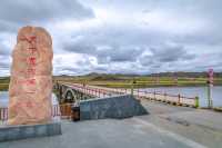
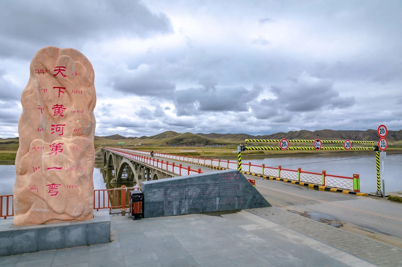
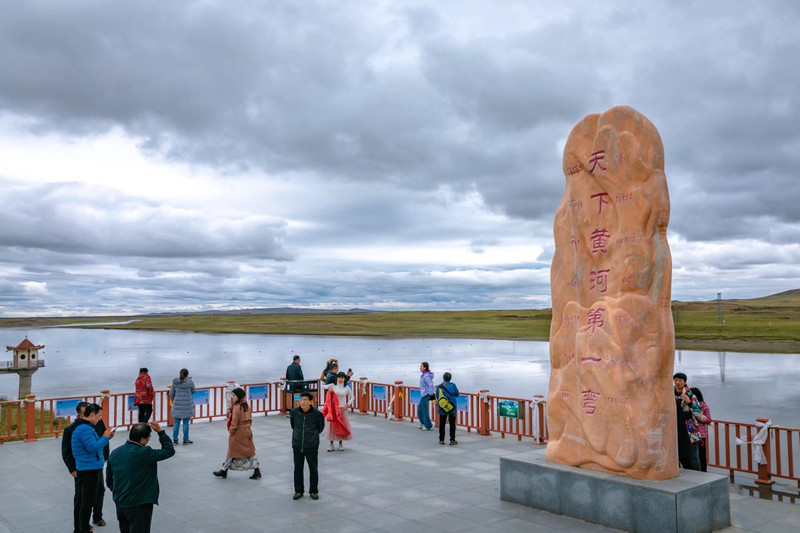
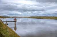
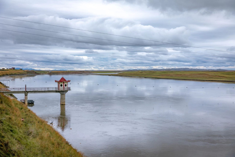
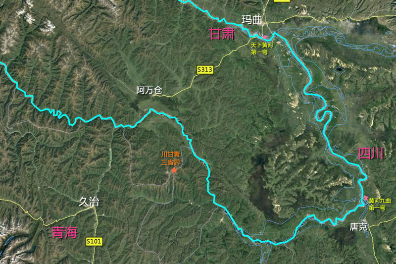
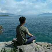
📓 The first bend of the Yellow River is in Maqu County, Gannan, at an altitude of 3,400 meters. This attraction is not the first bend of the Jiuqu Yellow River in Tangke Township, Ruoergai County, Sichuan, but the Yellow River bend next to the Maqu Yellow River Bridge. 📓 The Yellow River came out of Qinghai for a long time, flowing through northern Sichuan, Gannan and other places, turning a big bend in Tangke in Ruoergai, flowing back to Qinghai from Maqu, forming a 433-kilometer U-shaped giant curve, more than 40 kilometers wide, this big arm bent across Muxihe, Awancang, Qihama, The four townships of Cairima, the most curved is Cairima Township. 🏞 Maqu "The First Bend of the Yellow River in the World" and the upper reaches of Ruoergai Tangke "The First Bend of the Yellow River" refer to the same big bend. To see this big bend completely, it is only seen on the map (see the map icon I made). 💗 The first bend observation deck of the Yellow River in the world can't see any turn of the Yellow River. The Yellow River water is relatively open and calm here, and the surrounding scenery is more ordinary. Maybe the season is wrong, probably the corner in the field.
;
First Bend of the Yellow River in the World Tourism Scenic Area Review
4 /512 Reviews


1 / 6


2/5
First Bend of the Yellow River in the World Tourism Scenic Area
Posted: Nov 11, 2020


8 person liked this
Like
 5/5OutstandingOriginal Text
Tickets 100, it is recommended to come in autumn, if autumn comes, autumn is high, very good, the environment is very good, it will be very cold at night. The tourist scenic spot is particularly large. If you don't take the elevator, you can go up by yourself. The ticket for the elevator is 40 yuan.
Posted: Jun 18, 20211 Original Text
#My flying moment Chaka Salt Lake Zhagana Maqu World Yellow River First Bend Tourist Scenic Area We are not really eager to travel, we are not really eager to see the mountains, water, and scenery, but this soul, bound by the city, tied up, too long, we need to find our true self, That is probably the meaning of travel.
Posted: Apr 30, 20220 5/5OutstandingOriginal Text
The first bay of the Yellow River is very commemorative. Improve the core socialist values.
Posted: Dec 12, 20200 Original Text
🔸🔹🔸 Follow the pick of ears and a dog by car, and explore the niche travel in depth. #count the cool summer resort #star picking journey 🚙 Travel through Gannan by car remember that we walked through the grassland of Luqu, and then through Xiqing Mountain. The last stop in Gannan County came to Maqu County. Maqu is located at the junction of Sichuan and Ganqing provinces. The county covers the first bend of the Yellow River Jiuqu. The county is built on the upper right of the U-shaped bend of the Yellow River. Driving forward, we arrived at the Yellow River shortly after. The Yellow River water is both clear and majestic in this area. The weather is fine, and the wide river is magnificent. The first bridge of the first song crosses the river. The bridge was built in 1979 and is still open to traffic. This video starts here to explore the scenery near the first corner of the Yellow River. 📌 Self-driving travel Tips🛣 Road conditions: The road conditions are good along the way, and the car is feasible; 🎟 Tickets: free visit, free parking; ⌛️ Time: It is recommended to arrange 2 hours to visit the first bend; 🅿️ Parking: There is a viewing parking lot near the first bridge of the first song. ▶️ The above content is summarized according to personal travel experience. Please understand if there are omissions. ▶️ Affected by the time limit, some scenarios may change, whichever is the current one. ▶️ address location information is provided by the website. If you need more detailed information, please leave a message. 😷 Epidemic prompt: wear masks and do not gather. When traveling, you should avoid going to the risk area, try to choose self-driving travel & explore niche travel places. 🔸🔹🔸 You who like to travel by car and don't take the usual road, please listen to the ear canal of picking. #Self-driving tour Gannan #niche travel places
Posted: Jul 11, 20220 Original Text
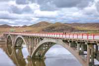
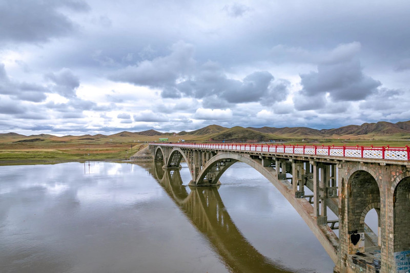
"The Yellow River in the world nine curves and eighteen bends, the most beautiful is the first bend!" Yellow River as the mother river of the Chinese nation, many places call their own Yellow River the first bend, in fact, the closest to the source of the Yellow River "the first bend of the Yellow River", is in Gannan Prefecture, Gansu Maqu County. Maqu, the translation of the Tibetan "Yellow River", is also the only county in the country named after the mother river of the Chinese nation. The reason why Maqu County has the reputation of "the first bend of the Yellow River in the world" is because the Yellow River originates from Qinghai Bayan Kala Mountain, enters the territory of Maqu County east, and then returns to Qinghai Province northwest along the Animaqing Mountain and Xiqing Mountain. The entire Panhuan route is 433 kilometers long. The prestigious "first bend of the Yellow River in the world" has been formed, because this bend is too big, people can hardly feel its existence. Maqu County occupies the first song of the Yellow River Jiuqu, the water resources are very rich, and the Yellow River section in the country is also flowing rapidly. For thousands of years, the only way people want to cross the river is to swim with their horse tails, so there is little communication between the people along the river, and even the customs are very different. In April 1976, the Maqu Yellow River Highway Bridge opened 4 kilometers away from the county seat. In 1979, the "Maqu Yellow River Bridge" was completed and opened to traffic. The bridge is a reinforced concrete arch bridge, with a total length of 280 meters, a width of 7.5 meters, a main span of 3 holes, a span of 70 meters, and a net height of the lowest string under the bridge. Although the bridge does not look as grand as some of the bridges downstream of the Yellow River, it is the first bridge built in Maqu on the upper reaches of the Yellow River, and is therefore also known as the "First Bridge of the Yellow River". It is worth mentioning that the "Maqu Yellow River Bridge" was built in the high-altitude oxygen-deficient permafrost, which was an extraordinary feat at the time. It is understood that the volume of frozen frozen soil will expand in the cold season, and the bridge base built on it will be raised by the "fat" frozen soil. In summer, the volume of the melted frozen soil will shrink, and the bridge base will be concave. This situation will alternate with the freezing and melting of the frozen soil. Standing on the Maqu Yellow River Bridge overlooking the mother river, the yellow turbid river flows from east to west, like a smooth drifting belt slipping between the world. On the Maqu grassland on both sides of the river, cattle and sheep are flocked, snow-capped mountains and lakes are intersected, and the Maqu County in the distance is vaguely visible. Faced with this fairyland-like place, passers-by will stop and watch and appreciate the gift of nature. Maqu Yellow River Bridge and two beautiful landscapes should not be missed: First, "arch bridge day", standing on the left side of the bridge in the early morning, you can see the east red sun rising, when the red sun rises to the bridge, just like the arch bridge to lift a red sun. Second, the "long river sunset", at sunset standing on the bridge looking at the rolling Yellow River, the sunset sinks, just like falling into the long river, the scene is quite spectacular. According to legend, Maqu is also the hometown of King Gesar. In the majestic wood road of Gesar's birthplace, 4 kilometers west of the bridge, visitors can enjoy the magnificent landscape of the Yellow River falling from the sky. More than 10 kilometers northeast of the county seat, tourists can also see the whole picture of the small song similar to the whole picture of the first song, which is pleasing to the eye and breathtaking.
Posted: Dec 4, 20210- 1
- 2
- 3
Recommended Attractions at Popular Destinations
Bangkok attraction near me | Tokyo attraction near me | Manila attraction near me | Hong Kong attraction near me | Taipei attraction near me | Seoul attraction near me | Los Angeles attraction near me | New York attraction near me | Shanghai attraction near me | Kuala Lumpur attraction near me | Shenzhen attraction near me | Osaka attraction near me | Singapore attraction near me | London attraction near me | Guangzhou attraction near me | San Francisco attraction near me | Beijing attraction near me | Macau attraction near me | Bali attraction near me | Paris attraction near me | Ho Chi Minh City attraction near me | Orlando attraction near me | Jakarta attraction near me | Chicago attraction near me | Phuket attraction near me | Toronto attraction near me | Fukuoka attraction near me | Istanbul attraction near me | Dallas attraction near me | Chiang Mai attraction near me
Popular Attractions
Adventure Cove Waterpark | Old Orthodox Church | Sannenzaka & Ninenzaka | Chengdu Research Base of Giant Panda Breeding | Sunway Lagoon Theme Park | Gunung Banda Api | Grandview Aquarium | Guangzhou Ocean Aquarium | Dujiangyan Irrigation System | The Legacy Golf Course | Hong Kong Disneyland | WILD LIFE Sydney Zoo | Redwoods – Whakarewarewa Forest | Thepsuda Bridge | Autumn moon on the calm lake (Pinghu Qiuyue) | Lingering Snow on the Broken Bridge | Orioles Singing in the Willows | Calverts Hill | Boquete Brewing Company | Guily Fish Spa | Grupo Desportivo Monte Real | राम जानकी मंदिर Ram Janki temple | Castillo de Montemar | Cvičák ZKO Hranice | MRK Contemporary Art Gallery | Carson River Park | Stadtbücherei | Shiv Mandir Manki Mandir | Posas de agua SANTA ISABEL | Singapore River Cruise
Payment Methods
Our Partners
Copyright © 2024 Trip.com Travel Singapore Pte. Ltd. All rights reserved
Site Operator: Trip.com Travel Singapore Pte. Ltd.
Site Operator: Trip.com Travel Singapore Pte. Ltd.