虽然是青海的小众景点,但是其独特的地质景观景色非常值得一游!我喜欢,我推荐!
;
Ashgang Colorful Peaks Scenic Area in Guide National Geological Park Review
4.6 /5737 Reviews


1 / 6


5/5
Verified Booking
Ashgang Colorful Peaks Scenic Area in Guide National Geological Park
Posted: Nov 8, 2020
Like
 5/5Outstanding
Verified Booking
Original TextThe gem of nature, Colorado, China, very special terrain and landforms, a different experience, Guide is a treasure, and two places near Xining are the ghosts of nature.
Posted: Dec 29, 20230 5/5Outstanding
Verified Booking
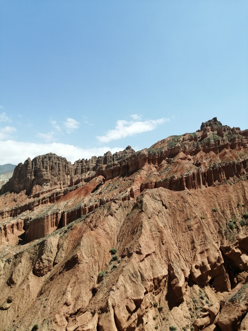
Original TextVery close to Guide from Xining, it is recommended to go and see! It's really beautiful! The park is not very big, free for over 60 years old! Tickets 30 yuan! Small train 🚄 30 yuan! From the beginning of the door, there is a service staff to lead, first watch the promotional film, then explain, then do the car, the driver drives all the way to explain, very good experience! It takes only 2 kilometers to walk, and there is no problem with the elderly. Because of the crustal movement, the previous sea has become a mountain. Due to different geology, different wetness and different colors, there are five colors of soil in the park, and the mountain presents a few different colors of landscape! so beautiful! Very spectacular, very beautiful, similar to Zhangye Danxia landform landscape!
Posted: Nov 8, 20232 5/5Outstanding
Verified Booking
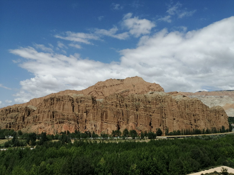
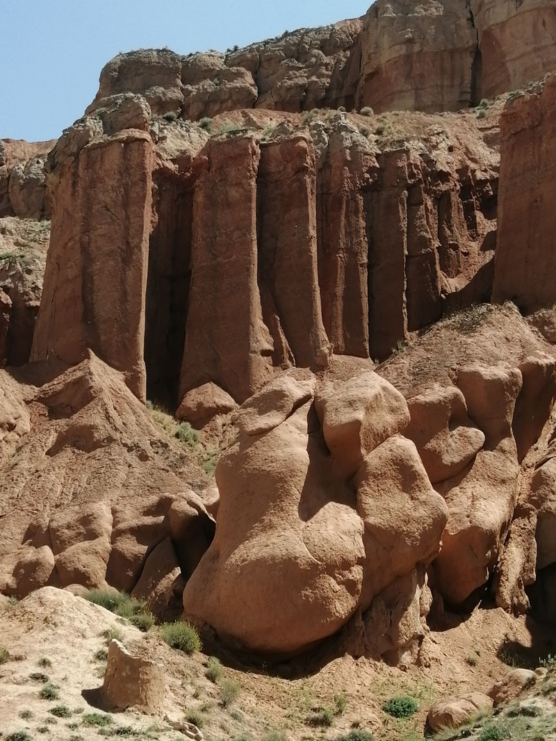
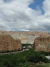
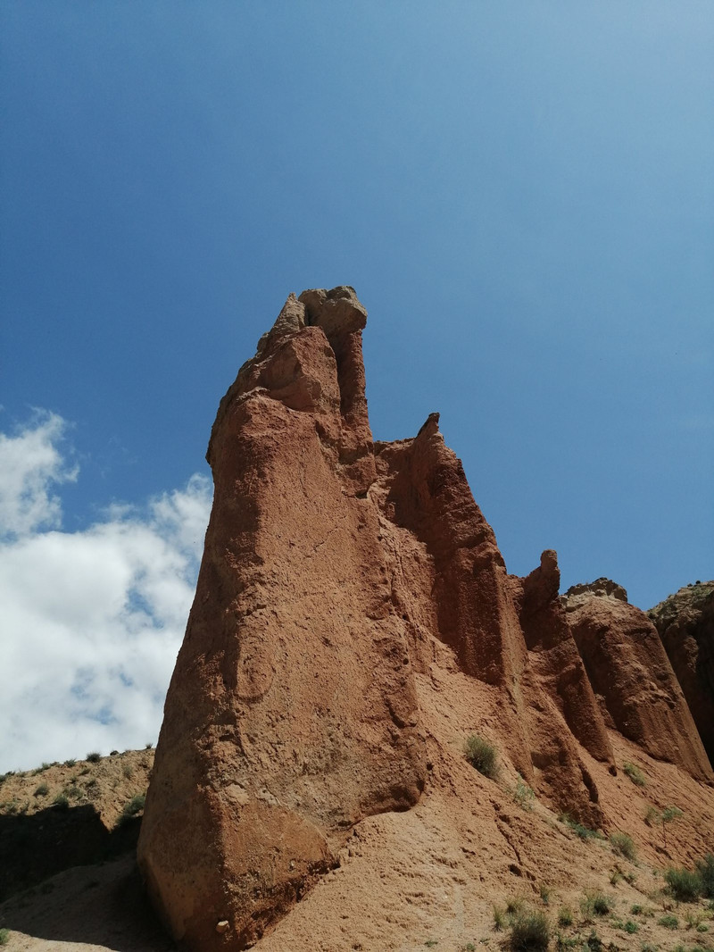
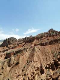
Original TextGuide National Geopark is also called Ashgong, located in Ashgong Village, Yanran Township, Guide County, Hainan Prefecture, Qinghai. From Guide County, cross the Guide Yellow River Bridge, along National Highway 227, cross the Yellow River Wetland Park, and see a Danxia Peak group. In front of the ticket office of the scenic spot is a large square and parking lot, the north is the entrance of the scenic spot, and the south is the exit. The scenic spot is composed of 13 cultural theme squares and seven Danxia Canyon. The interior area covers 3,000 mu and the exterior area covers 50,000 mu. Danxia landform is developed from red sandstone, Ashgon Danxia landform, formed 120 million years ago. The red sandstone layer is cut under the Yellow River and the Himalayas are uplifted, so that the red sandstone hidden deep in the formation is exposed, and after thousands of years of erosion and strong wind sculpture, it has formed a thousand-shaped rock cliff. Enter the scenic spot, on the cement-built square, the style of Danxia around you is different, the sun is strong, and the white clouds are rising. In the center of the square, there are stone carvings in the shape of Guide County, and the blue Yellow River runs through them. The stone carvings say "Qinghai Guide National Geopark". There is a geological museum on the east side of the square, which is displayed in pictures and images. The narrator spoke very quickly, and the introduction ended after a while. I felt that the significance of the visit was not great. The museum came out and walked north along the square to the mountain gate. There are two top columns in the mountain gate, and the book "the earth veins are stretching on the ground, and the people are the source of the ancient love." The link is not neat, but it is more suitable for the scene. Crossing the pedestrian bridge, facing a small door, the book "Colorful Peak Cong, the earth behind the wall". Enter this door
Posted: Sep 10, 20223 5/5Outstanding
Verified Booking
Original TextUnexpected scenery, originally planned to go to Zhangye, but the reason for the distance temporarily changed to here, the geological park does not lose Zhangye, very pleasant experience. There is also a free explanation, the arrangement is very good.
Posted: Jan 26, 20240 5/5Outstanding
Verified Booking
Original TextSegmented tour guide, patient explanation, free but very professional, awesome
Posted: Jul 27, 20230 5/5Outstanding
Verified Booking
Original TextIt is a relatively cold attraction, there are not many people, you need to drive by yourself to get there, the scenery and service are not bad. Tickets ➕ Cruise boats are 100 in total, and the price of Trip.com group purchase is 85. The cruise time is about 35 minutes.
Posted: Jul 23, 20231- 1
- 2
- 3
- 4
- 100
Recommended Attractions at Popular Destinations
Bangkok attraction near me | Tokyo attraction near me | Manila attraction near me | Hong Kong attraction near me | Taipei attraction near me | Seoul attraction near me | Los Angeles attraction near me | New York attraction near me | Shanghai attraction near me | Kuala Lumpur attraction near me | Shenzhen attraction near me | Osaka attraction near me | Singapore attraction near me | Guangzhou attraction near me | London attraction near me | San Francisco attraction near me | Beijing attraction near me | Macau attraction near me | Bali attraction near me | Paris attraction near me | Ho Chi Minh City attraction near me | Orlando attraction near me | Jakarta attraction near me | Chicago attraction near me | Phuket attraction near me | Toronto attraction near me | Istanbul attraction near me | Dallas attraction near me | Cebu attraction near me | Seattle attraction near me
Popular Attractions
Koshimizu Primeval Flower Garden | Movie Time cinemas, Omaxe Novelty Mall, Amritsar | Sa Pa | Polynesian Spa | Huangpu River Tour(16 Pu Pier) | Paradise Valley Springs | Zhagana | Lithuanian Culinary Museum | Dreamworld | Puffing Billy Railway | Tanque de Agua Alhama Springs Senderismo | Lake Tekapo | Skyline Rotorua | Coffee Museum of Puerto Rico | Nantian Gate | Autumn moon on the calm lake (Pinghu Qiuyue) | Air Auckland | Orioles Singing in the Willows | Leifeng Tower | Agaramthen Lake Checkdam - அகரம்தென் ஏரி கலங்கல் | Maharudra Hanuman Temple | Park w Mirkowie | Parc Albert-Schweitzer | Parc | George G. Newton Nature Reserve | Naveen Talkies | Gorges de l'Hérault | Palazzo delle Prigioni | Boeddha's & More | Auckland Zoo
Payment Methods
Our Partners
Copyright © 2024 Trip.com Travel Singapore Pte. Ltd. All rights reserved
Site Operator: Trip.com Travel Singapore Pte. Ltd.
Site Operator: Trip.com Travel Singapore Pte. Ltd.