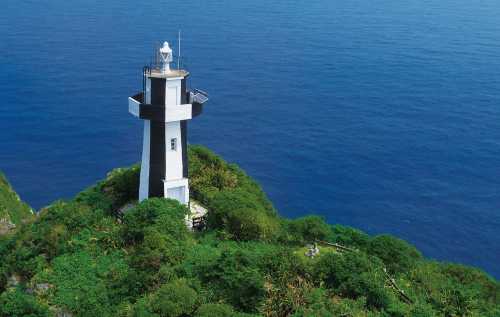
—登頂步道 × 島燈塔:把東北角的海天收進 360° 的藍 💙🏝️")
—登頂步道 × 島燈塔:把東北角的海天收進 360° 的藍 💙🏝️")
—登頂步道 × 島燈塔:把東北角的海天收進 360° 的藍 💙🏝️")
—登頂步道 × 島燈塔:把東北角的海天收進 360° 的藍 💙🏝️")
—登頂步道 × 島燈塔:把東北角的海天收進 360° 的藍 💙🏝️")
1 / 5


Mentioned in this post
Keelung
Details
Show more

Popular Trip Moments
🌊Agena Shipyard Ruins|A poem of ruins on the Keelung coast, a romance of steel and sea breeze | 🌈【Zhengbin Fishing Port】Keelung's colorful and dreamy Little Venice | Heping Island Park – Taiwan | See the strange rocks in Heping, Taiwan. | Zhengbin Port Color Houses ไต้หวัน | Keelung Attractions: Keelung Ghost Festival, Keelung Tower, Tianliao River | Keelung's Must-Visit Free Attraction: Chaojing Park | Hidden in the alleys of Keelung is a hipster cafe☕️ | Keelung|Keelung Islet (Part 2) — Summit Trail × Island Lighthouse: Frame the Northeastern corner of the sea and sky in 360° of blue 💙🏝️ | Keelung | Keelung Island (Central Section) Landing (Harbor Trail, Coastal Trail, and Seaside Promenade) — Turning the volcanic island's coastline into a breathtaking blue poem ✨🏝️ | Keelung | Keelung Islet (Part 1): Island Cruise—Experience the Sea and Capture the Contours of a Volcanic Island in a Blue Album | Keelung|Bisha Fishing Port—A half-day trip to enjoy the mountain bay, sea of clouds, and seafood 🐟⛵️ | Baimeiweng Fort | Wanghai Lane Fishing Harbor | 📍Wufenche Tunnel next to Zhengbin Fishing Port🚂Nostalgic Secret Place | 📍Keelung Zhengbin Fishing Port🌈The most beautiful colorful houses | Keelung's Sea | Review of travel outside of Taipei | 🌈✨ Rainbow House, Keelung City, Taiwan ✨🌈 | Northern Attractions: Keelung Ocean Plaza, Miaokou Night Market, Ren'ai Market | Agena Shipyard: The Mark of Time in the Aesthetics of Ruins | 🌊 : Heping Island GeoPark, Keelung, Taiwan | 🪨 : Heping Island GeoPark เที่ยวไต้หวัน | Keelung Ghost Festival 2025 – Where Faith, Culture, and Compassion Meet | 5 Things You Can’t Miss in Keelung, Taiwan 🌊 | Taiwan's North Coast Tour! Chaojing Park, Zhengbin Fishing Port, and the Shen'ao Rail Bike Trail | Keelung Tower: A New and Must-Visit Landmark in the Heart of Keelung City | Keelung Must-Visit Spots! Temple Street Delicacies + Air-Raid Shelter Adventure in a One-Day Tour | 🌊"The sea breeze blows on my face, and the magnificent scenery on the isolated island."
Recommended Attractions at Popular Destinations
Popular Attractions in Singapore | Popular Attractions in Shanghai | Popular Attractions in Melbourne | Popular Attractions in New York | Popular Attractions in Barcelona | Popular Attractions in Walt Disney World Resort | Popular Attractions in Bangkok | Popular Attractions in Chefchaouene | Popular Attractions in Bali | Popular Attractions in Los Angeles | Popular Attractions in Kuala Lumpur | Popular Attractions in Beijing | Popular Attractions in West Lake | Popular Attractions in Paris | Popular Attractions in Sydney | Popular Attractions in Las Vegas | Popular Attractions in Osaka | Popular Attractions in Phuket | Popular Attractions in Iguazu National Park(Argentina) | Popular Attractions in Kyoto | Popular Attractions in Zanzibar Island | Popular Attractions in London | Popular Attractions in Rome | Popular Attractions in Tokyo | Popular Attractions in Dubai | Popular Attractions in Chengdu | Popular Attractions in Florence | Popular Attractions in Jungfrau Region | Popular Attractions in Madrid | Popular Attractions in Hangzhou
Popular Attractions
Daming Temple | Geyuan Garden | He Garden | Gumulan Yard Shita | Xinghai Park | Wenfeng Tower | Crane Temple | The Shi Kefa Museum | Dalianwan Fort | Yangzhou Shuangbo Museum | Yechun Garden | Jiaoshan Mountain | Zhanqiao Park | Baisha Murals | Hong Kong Police Museum | Hanpo Pass | Huajing | Huanglongtan | Shiv Temple | Dijon Opera | Dubrovnik Diving Aquarius | Ambedkar Park Kasidaha | Château Fonréaud Chateau Fonreaud | Mosque University of Khartoum | Northern Lights Arcade | Square Saint Hilaire | Perea (la rectita manito) | Little Qingdao | Lu Xun Park
Popular Restaurants in Keelung
Poppy Flower Fusion Hot Pot Food | Keelong Senki Coffee | 基隆廟口松山海鮮 | Tianyixiangrougengshun | 新新牛軋糖 | 閒閒 | Local Snacks | 好好咖啡 | Xing Kee | 21金小火鍋臭臭鍋 (基隆廟口店) | Pigs' Knuckles Lin Original-Flavored | STARBUCKS - Ferry Harbor | 福記蔬菜羊肉 | 王記天婦羅(基隆廟口16攤店) | Huo Li Zhan Konjac House | Three Sis Seafood | Cafe | Yingyangsanmingzhi | Mykonos Cafe | Ms.Belly | 富哥燒烤 | 海上鮮 | Ahua Fried Noodle | Crab Thick Soup | Soup City Light Hot Pot | Shang Hao Wei Buffet | 三姊妹水煎包 | Acai Three-Delicacy Dumplings | Supper Spicy Hotpot - Keelung | 新環港海鮮餐廳
Popular Ranked Lists
Top 10 Trending Attractions in Shenyang | Top 50 Must-Visit Restaurants in Hanoi | Popular Trending Attractions in Baoding | Popular Premium Hotels in Suffolk Park | Popular Premium Hotels in Tsaghkadzor | Popular Trending Attractions in Putian | Top 50 Must-Visit Restaurants in Auckland | Popular Premium Hotels in Mlini | Popular Premium Hotels in Pokolbin | Popular Trending Attractions in Yangcheng | Popular Premium Hotels in Nui Thanh | Top 50 Must-Visit Restaurants in Kunming | Popular Premium Hotels in Sagres | Top 50 Must-Visit Restaurants in Ho Chi Minh City | Top 10 Trending Attractions in Hohhot | Popular Trending Attractions in Jilin | Top 50 Must-Visit Restaurants in Xiamen | Popular Premium Hotels in Costa | Top 50 Must-Visit Restaurants in Rome | Popular Trending Attractions in Jiande | Top 50 Must-Visit Restaurants in Washington D.C. | Popular Premium Hotels in Paihia | Popular Premium Hotels in West Yorkshire | Top 10 Luxury Hotels near Thai Binh | Popular Trending Attractions in Jingzhou | Top 50 Must-Visit Restaurants in Bali | Top 50 Must-Visit Restaurants in Berlin | Popular Premium Hotels in Shirdi | Popular Trending Attractions in Karamay | Top 50 Must-Visit Restaurants in Dalat
About
Payment methods
Our partners
Copyright © 2025 Trip.com Travel Singapore Pte. Ltd. All rights reserved
Site Operator: Trip.com Travel Singapore Pte. Ltd.
Site Operator: Trip.com Travel Singapore Pte. Ltd.