OverviewBookNearbyReviewsWin PrizesRecommended
Share to
Diexi Earthquake Site (Diexi Haizi)
疊溪地震遺址(疊溪海子)3.8
32 Reviews
Open year round, 24/7
Recommended sightseeing time:1 hour
Address:
About 2.5 kilometers southeast of Maochang Township, Mao County, Aba PrefectureMap
What travelers say:
In 1933, the 7.5 magnitude earthquake caused the peaks on the banks of the Lijiang River to fall more than 500 meters straight, and the heavy town of Silk Ling, more than 270 meters above the river, collapsed and disappeared in a white land. 21 Dongzhais were destroyed, and 6,865 people were killed. On the 45th day after the earthquake, the lake broke the dam, and the 20-foot high wild waves poured down, destroying the Dujiangyan water conservancy facilities, and killing more than 2,500 people. The earthquake left two large and small seas of relatively stable geological sheds and Baiwazhai, which is today's Diexi Haizi.
More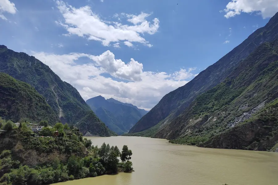
See all 2 photos
Diexi Earthquake Site (Diexi Haizi) Highlights: Must-See Features and Attractions
Some information may have been translated by Google Translate
The Diexi Earthquake Site is located 2.5 kilometers southeast of Jiaochang Township, Maoxian County, on the second-level platform on the east bank of the Minjiang River, with Qizhu Mountain as its back and Minjiang River down, with an area of 220,000 square meters. According to literature records, Diexi Han was Canling County, early Tang was Jizhou, Ming Dynasty was Diexi Qianhuo, Qing Dynasty was changed to Wei, and later it was attached to Maoxian. Diexi City was built during the Zhenguan period. In the eleventh year of Ming Hongwu, the imperial envoy Ding Yu asked Tong Sheng to restore the old place. It was one zhang high, three hundred and dozens of zhang around, and four gates. Xicheng is located on the edge of Songmao Road, which is not only an important military town but also a distribution center for merchants and tourists. On August 25, 1933, a strong earthquake with a magnitude of 7.5 occurred here. At that time, the central part of the entire Diexi City collapsed almost straight, and all 21 Qiang villages were submerged. dammed lake. The local people are used to calling the lake "Haizi", so this dammed lake of more than 3.5 million square meters was named "Diexi Haizi", with a total of two Haizi. After the earthquake, only a corner of the east gate of the ancient city remains, and a section of the south wall has a stone lion, a stone roller, a stone tablet and a stone jar. The site is still well preserved, and is an important site for the international earthquake research community to study earthquakes, and a state-level cultural relics protection unit. In addition, there are also some scenic spots such as Jiangtai, Fugui Mountain, Stealing Oil Cave, Yulei Cave, and the return tour of the tortoise.
Recommendations Near Diexi Earthquake Site (Diexi Haizi)
Diexi Earthquake Site (Diexi Haizi) Reviews: Insider Insights and Visitor Experiences
Some reviews may have been translated by Google TranslateWrite a Review
/5
Good ReviewsAll (32)
Latest
With Photos (23)
Positive Reviews (23)
Negative Reviews (3)
- 1
- 2
- 3
- 4
- 7
You Might Also Like
Dujiangyan Scenic Area
9.3
4.7/535850 Reviews
From JPY 1,769
Taoping Qiang Village
5.6
4.4/5775 Reviews
-JPY 663
From JPY 664
Qingcheng Mountain
8.8
4.6/517083 Reviews
From JPY 1,769
Mianyang Fantawild Oriental Heritage Park
7.2
4.9/520008 Reviews
From JPY 6,611
Nearby Attractions
Ancient Qiang City of China | Taiziling Ski Resort | Jiuding Mountain | Baishi Qiang Village | Pingtou Qiangzhai | Prince Ridge, Jiuding Mountain | China Qiang Ethnic Minority Group Museum | Black Tiger Qiang Village | Moutuo Qiang Ethnic Minority Village | jiu ding shan lu ying ju le bu | Qingping Fairy Tale Town, Mianzhu | Radish Village | Qiangzhai Mountain Resort | Beili Range | jin se qing ping jing qu | hei hu gou lv you jing qu | Happy Ranch | Yingfei Valley | Pingtouzhainuo Culture Square | wen chuan kai xin nong chang - lu ying di | wei qiang qiang zu yin shi bo wu guan | Aergou Peak | bei chuan hei shui qiang zhai | jin se qing ping tong hua xiao zhen lu ying ji di | zhong guo gu qiang cheng - guan jing tai | Mianzhu Qingping Mini-trains | luo bo zhai qiang wen hua sheng tai lv you qu | hong zhao bi | Sichou Museum | Xiqiang Resort
Popular Types of Attractions in Mao County
Architecture & Landmarks | Squares | Featured Neighborhoods | Historical Architectures | Nature | Mountains | Lakes | Flower Fields | Religious Sites | Memorial Temples | Churches and Cathedrals | Temples | Parks | City Parks | Children's Play Areas | Botanical Gardens | Lifestyle | Campgrounds | Libraries | Resorts | Exhibition Centers | Museums | Fine Art Galleries | Memorial Halls | Historic Sites | Historical Sites | Ancient Towns | Ancient Villages | Traditional/Cultural Experiences | Villages
Popular Restaurants in Mao County
石磨豆花家常菜 | 羌家毛毛菜 | 品味農家羌族特色土火鍋 | LI ZHUANG BAI ROU | 茂縣千山雪設計師民宿·餐廳 | Rongchengmingpian Hot Pot (maoxian) | 成渝鮮活匯豆腐魚 | 三香閣家常菜 | 清香閣(犛牛肉) | Daqianghuopen Barbecue (maoxian) | 藍竹篾片古羌鼎烹菜 | 三人行烤肉 | Maoxianshanweitangguo | 茂縣九頂山國際大酒店·正餐廳 | 龍記斑魚莊(茂縣店) | 麵包故事 | 茂縣西羌家園酒店·西羌苑餐廳 | 茂縣國際飯店-中餐廳 | CHENG DOU YONG JIU LIAN YU CHUAN CAI | 安氏烤全羊 | PAN GE MIAN GUAN | 好望角炭火烤肉 | 絕味鴨脖 | 山野鄉味川菜館 | 羌風羌炒菜坊 | 三不咖啡 | 大草原氂牛雜火鍋(茂縣店) | 十分熟羌家 | 徐渡周雞肉川菜館 | 茂縣尚品魚頭火鍋店
Recommended Attractions at Popular Destinations
Bangkok attraction near me | Manila attraction near me | Tokyo attraction near me | Taipei attraction near me | Hong Kong attraction near me | Seoul attraction near me | Los Angeles attraction near me | Kuala Lumpur attraction near me | Shanghai attraction near me | New York attraction near me | Shenzhen attraction near me | Osaka attraction near me | London attraction near me | Singapore attraction near me | Guangzhou attraction near me | San Francisco attraction near me | Beijing attraction near me | Macau attraction near me | Bali attraction near me | Paris attraction near me | Jakarta attraction near me | Ho Chi Minh City attraction near me | Orlando attraction near me | Phuket attraction near me | Toronto attraction near me | Chicago attraction near me | Cebu attraction near me | Seattle attraction near me | Istanbul attraction near me | Fukuoka attraction near me
Popular Ranked Lists
Popular Luxury Hotels Near Adler | Top 19 Local Restaurants in Manchester | Top 8 Bars in Cape Town | Top 21 Local Restaurants in Frankfurt | Popular Family-friendly Attractions Near Chengbu | Top 3 Luxury Hotels in Lake Lucerne | Top 20 Local Restaurants in Krabi | Popular Premium Hotels in Fuschlsee | Popular Family-friendly Attractions Near Qionghai | Popular Family-friendly Attractions Near Liangshan Prefecture | Top 10 Bars in Amman | Top 20 Local Restaurants in Madrid | Popular Premium Hotels in Lichuan | Top 19 Local Restaurants in Luoyang | Top 17 Local Restaurants in San Francisco | Popular Luxury Hotels Near Settimo | Popular Family-friendly Attractions Near Yanshan | Popular Premium Hotels in Mougins | Top 15 Local Restaurants in Doha | Popular Family-friendly Attractions Near Huize | Top 10 Local Restaurants in Brisbane | Popular Premium Hotels in Sao Martinho do Porto | Popular Family-friendly Attractions Near Tongbai | Popular Family-friendly Attractions Near Huaibin | Popular Family-friendly Attractions Near Ulanhot | Popular Luxury Hotels Near Sylhet | Popular Premium Hotels in Fushe Draci | Popular Premium Hotels Near Whitsundays | Popular Luxury Hotels Near Saint-Trojan-les-Bains
Popular Trip Moments
Two-day tour of Songpinggou, Mao County | Jiuding Mountain | Chengdu's own Altay, round trip on the weekend! | Within 2h from Chengdu | A sea view in the mountains | Songpinggou is a great autumn destination around Chengdu | Watching the sea of clouds among the mountains, one can pluck the stars with their hands! Jiuding Mountain offers leisure for half a day | In summer, let's go to Jiuding Mountain together | Bielie Pasture: A Hiking Paradise | Inside the Ancient Qiang City in China | The Qiang Nationality Museum of China | Entrance to the Ancient Qiang City in China | Maoxian in Sichuan Province is a key town of Canling | Jiuding Mountain, you are truly amazing!! | The Most Familiar Stranger||Qiang Village | Sea of clouds, rime, snow mountain, Taizi Ridge Skiing | A round trip to Maoxian County in Aba can be done in half a day | 【Sichuan Maoxian ~ Ancient Qiang City of China】 | Songpinggou, the 'Little Jiuzhaigou' of Western Sichuan | Songpinggou immersive starry sky and western Sichuan parent-child holiday hotel first choice! | A high-quality homestay under a snow mountain in the suburbs of Chengdu | The severely underestimated autumn appreciation treasure--Abazhou Diexi·Songpinggou is picturesque | Gao Tie Maoxian Station|A day trip of eating, drinking, and playing under the snow mountain | Red leaves, shining so brightly because of the warm autumn sun | Hike the Himalayas 🏔 4 Hours from Chengdu | Taiziling Ski Resort Weekend ,Chengdu ⛷️⛷️ | Mountain Pass Peak in Sichuan's Aba | Beautiful Mountain Lake in West-Sichuan | Taiziling Ski Resort, Aba, Sichuan
Popular Travel Types
More Things To Do in Mao County
Chengdu to Jiuzhaigou Scenic Area Huanglong Classic 3-day Tour with Experienced Local Driver Tickets | 4-Day Jiuzhaigou and Huanglong National Parks Private Tour: Jiuzhaigou County, Jiuzhaigou Natural Reserve, Songpan County, Diexi Songpinggou Scenic Area | 4-Day Jiuzhaigou and Huanglong National Parks Tour from Chengdu | Chengdu Jiuzhaigou and Huanglong National Park 4-day tour | China eSIM Day Pass/data Package days selected without cards QR code | China Mainland eSIM|China Mobile Unlimited 4G High Speed Data | China·Hong Kong·Macau eSIM|Unlimited 4G High Speed Data | [China Mainland] eSIM | SIM to China | 8GB 8days 4G high speed | Asia・Australia eSIM|AIS SIM2Fly 8 days 6GB High-speed Unlimited 5G/4G Data | Global (66 Countries) eSIM Data Package (QR Code) | Mainland China + Hong Kong + Macau eSIM 4G Data Daily Plan QR Code | Mainland China eSIM |China Mobile 4G high-speed unlimited data eSIM | China/Hong Kong/Macau eSIM 4G high-speed network QR code | eSIM for China, Hong Kong and Macau. Universal for Mainland China/Hong Kong/Macau. Optional days for travel and business. QR code | Mainland China + Hong Kong + Macau eSIM Data Plan QR Code | Dujiangyan Panda Base Volunteer Tour | Dujiangyan Panda Volunteering Experience with Lunch | Panda Keeper Volunteer Experience in Dujiangyan/Wolong/Bifengxia Panda Base All Inclusive Day Tour | Chengdu Day Tour of Dujiangyan Irrigation System and Mount Qingcheng | Private Dujiangyan Giant Panda Park and Irrigation System Day Tour Optional Basic/All-inclusive Tour | Qingcheng Mountain and Dujiangyan Irrigation Construction Day Tour | Private Guided 1-Day Tour from Chengdu Dujiangyan Panda Base | China, Macau eSIM - Data plan by Gohub (QR Code) | Chengdu Guided Tour of Taoist Mountain and Dujiangyan Irrigation | Private One Day Panda Volunteer Tour from Chongqing by Bullet Train | Trip.SIM Japan, South Korea, Macau, Taiwan and many places in Asia + Australia and New Zealand 4G travel data roaming phone network card 4 days/7 days | Mainland China eSIM high-speed network QR code | Chengdu: Mt. Qingcheng and Dujiangyan Private Full Day Tour | Chengdu Private Half Day Tour: Sanxingdui Archaeological Museum | All-Inclusive Private Day Tour of Mount Qingcheng and Dujiangyan
Payment Methods
Our Partners
Copyright © 2024 Trip.com Travel Singapore Pte. Ltd. All rights reserved
Site Operator: Trip.com Travel Singapore Pte. Ltd.
Site Operator: Trip.com Travel Singapore Pte. Ltd.
In 1933, the 7.5 magnitude earthquake caused the peaks on the banks of the Lijiang River to fall more than 500 meters straight, and the heavy town of Silk Ling, more than 270 meters above the river, collapsed and disappeared in a white land. 21 Dongzhais were destroyed, and 6,865 people were killed. On the 45th day after the earthquake, the lake broke the dam, and the 20-foot high wild waves poured down, destroying the Dujiangyan water conservancy facilities, and killing more than 2,500 people. The earthquake left two large and small seas of relatively stable geological sheds and Baiwazhai, which is today's Diexi Haizi.
The Pentium River formed a very large-scale Fortress Lake here, surrounded by mountains, beautiful natural scenery, it formed in the Republic of China period of a huge earthquake, overnight the bustling Diexi ancient town was flooded by the earthquake fortress lake, almost no one escaped.
The lake formed by the 1933 earthquake is free. The toilet on the roadside was built by locals and charged 1 yuan. There are also some shops. The scenery of Diexi Haizi is average, there is an observation deck, and there are white yak for tourists to take pictures.
The power of nature, Haizi is called the mainland, and the Tibetan area is called "cuo"
【景色】【景色】【景色】【景色】【景色】景色不错
On the way to Jiuzhaigou in Chengdu, you must pass through Maoxian County and Diexi Haizi. The bus stops there to rest and you can see the scenery of Haizi. There is only one viewing platform, and locals take pictures with white yak. There are also some vendors selling various mountain goods. According to the tour guide, that place is full of pepper peppers, so you can buy some to take back, others... it depends on you are happy.