OverviewBookNearbyReviewsWin PrizesRecommended
Share to
Niyang River
尼洋河4.9
218 Reviews
Open year round, 24/7
Recommended sightseeing time:1-2 days
Address:
Within Linzhi City (mainly located in Gongbu Jiangda County and Bayi District)Map
What travelers say:
The scenic spots passing by the Yarlung Zangbo River Grand Canyon Scenic Area can be photographed on the platform, but if you have time, you can stay here for a day. The scenery here is beautiful.
MoreSaved by 3
Niyang River Highlights: Must-See Features and Attractions
Some information may have been translated by Google Translate
The Niyang River originates from the west side of Mila Mountain and joins the Yarlung Zangbo River on the south side of Bayi Town. It is the main river in Gongbujiangda County and Bayi District. The river is just beside the 318 National Road, driving on this section of the 318 National Road, accompanied by the river all the way. The landscape around the Niyang River is beautiful, with continuous plateaus and mountains and rivers along the way, especially the area near the Yarlung Zangbo Grand Canyon downstream is very beautiful. In the upper reaches of the Niyang River, there is also a famous landscape that is the mainstay, where tourists usually stop to take pictures.
Recommendations Near Niyang River
Niyang River Reviews: Insider Insights and Visitor Experiences
Some reviews may have been translated by Google TranslateWrite a Review
/5
Outstanding ReviewsAll (218)
Latest
With Photos (174)
Positive Reviews (137)
- 1
- 2
- 3
- 4
- 44
Niyang River Photos: Trip Moments
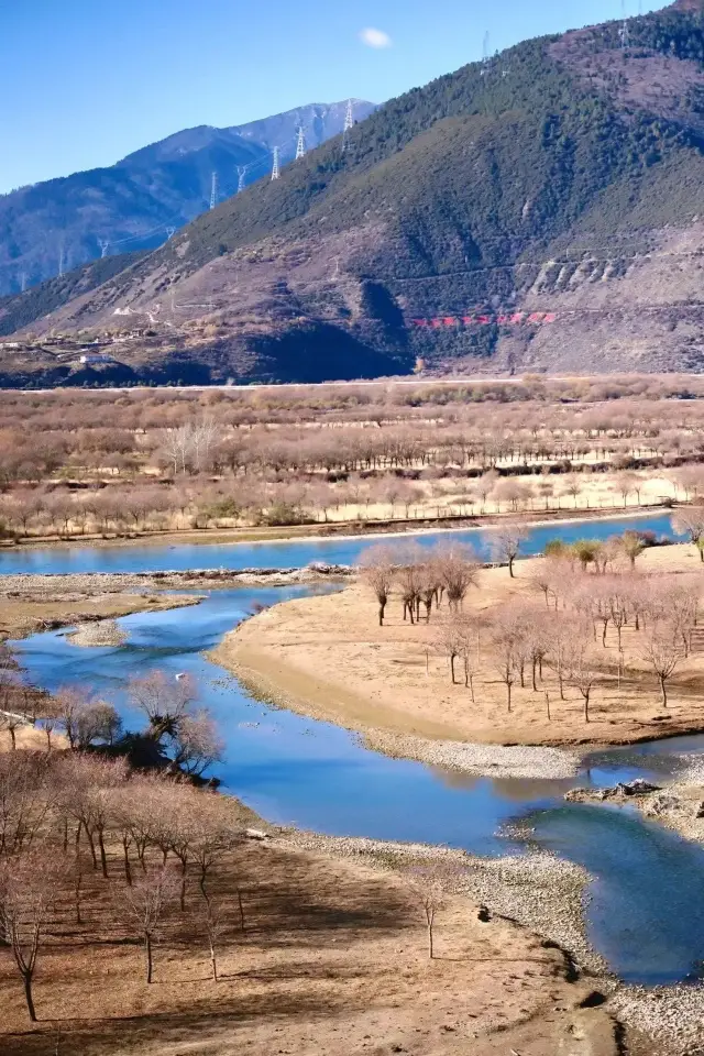 Niyang River Wetland in Nyingchi, TibetNiyang River, a river on the Qinghai-Tibet Plateau in China, with a total length of 307.5 kilometers and a catchment area of 17,500 square kilometers, ranks fourth among the tributaries of the Yarlung Zangbo River, but has abundant water, second only to the Parlung Zangbo River. The Niyang River originates from Cuomuliangla on the west side of Mila Mountain in the Tibet Autonomous Region of China, flows from west to east, and joins the Yarlung Zangbo River near Zemen in Nyingchi County. The Niyang River is the 'Mother River' of the Gongbu region in the Tibet Autonomous Region, also known as 'Niangqu', which means 'Tears of the Goddess' in Tibetan. The vegetation along the Niyang River is intact, the scenery is beautiful, the scenery is charming, there are many scenic spots along the way, and it is one of the rivers on the Qinghai-Tibet Plateau. The Niyang River has a large number of wild birds, and it is also a famous wintering area for black-necked cranes in Tibet. The Niyang River is the 'Mother River' of the Gongbu region, also known as 'Niangqu', which means 'Tears of the Goddess' in Tibetan. The source of the Niyang River has two major tributaries, one of which originates from Cuomuliangla on the west side of Mila Mountain, and the other originates from Litongla. The river is 307.5 kilometers long, with an annual runoff of 22 billion cubic meters, a catchment area of 15,459 square kilometers, flowing from west to east, parallel to the Yarlung Zangbo River, passing through Gongbujiangda County, Jiaxing Township, Jinda Town, Gongbujiangda Town, Bahe Town, Nyingchi County Baiba Town, Bayi Town, Pujiu Township, Mirui Township, and joins the Yarlung Zangbo River near Zemen in Nyingchi County, it is one of the five major tributaries of the Yarlung Zangbo River. The Niyang River has a large number of wild birds and is a wintering area for black-necked cranes in Tibet. Topography and climate: The Niyang River is located in the Nyingchi region of the Tibet Autonomous Region of China. Here, influenced by the warm current of the Indian Ocean and the cold current of the north, it forms the special tropical, subtropical, temperate, and cold zones of the Nyingchi region, and the humid and semi-humid coexistence of various climate zones, forming the unique snow mountain and forest world of the river basin area, forming the rare river valley scenery in the world, people call it the 'Jiangnan' of Tibet.FreeSpiritedWanderlust
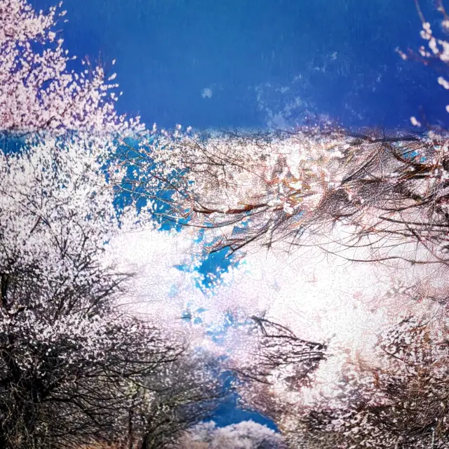 Spring Romance in Flower Viewing: The Dreamy Wonderland of NyingchiSpring in Nyingchi is hailed as the 'Jiangnan on the Roof of the World', where the city is poetically and dreamily adorned in pink peach blossoms! Flower viewing in Nyingchi during spring is a romantic encounter with peach blossoms, so beautiful that it makes you linger and forget to return! A Tibetan-style resort in the urban area of Nyingchi offers an elegant environment and complete facilities. Not only can you experience the warm hospitality of the Tibetan people, but you can also taste authentic Tibetan cuisine, such as butter tea and highland barley wine. At night, you can admire the starry dreamy night sky from the resort's terrace, feeling the tranquility and mystery of the plateau. The wild peach groves by the Nyang River are pleasing to the eye with their flourishing blossoms, creating a beautiful tapestry against the azure sky, pristine snow-capped mountains, and the jade-like Nyang River. Strolling along the riverbank, admiring the gorgeous peach blossoms while listening to the flowing river, feels like being in a fairyland.Luna_Winterthorn_52
 Tibet is back, travel guide for the Linzhi Lai Gu line🏆Route section: The first day: Depart from Lhasa → Niyang River Wetland Fairyland → Magnificent spectacle of Namjagbarwa Peak → Arrive at Suosong Village (For friends who suffer from altitude sickness on higher altitude sections, please prepare glucose or corresponding medicines in advance. The accommodation experience in Suosong Village is decent, not as luxurious as in the city, but has its own charm. Pay attention to keeping warm in winter and avoid bathing to prevent catching a cold! Thermometer💪Glacier medicine box) The second day: Explore the Yarlung Zangbo Grand Canyon → Check in at the Buddha Palm Sand Dune (The backstory is very interesting, a good place for taking photos, the scenery is relatively ordinary but still a sight to see) → Leisurely travel to Bomi The third day: Depart from Bomi → Ranwu Lake like a poetic painting → Visit the mysterious and spectacular Laigu Glacier (Getting up early is wise, as the wind gets stronger and colder after noon, you can choose to ride a horse or hike for the adventure, Laigu Glacier is definitely a visual feast! Snowy mountains and glaciers🐎) The fourth day: Depart from Bomi again → Pass by the tranquil hometown lake → Challenge the 4700 meters high Sejila Mountain (Occasionally encounter cute monkeys on the mountain top, remember to bring some snacks to feed them; if you encounter a snowy landscape, it is an excellent opportunity for photography, and with great luck, you may even have a distant view of Namjagbarwa Peak! Snowy mountains monkey group snowflakes❄️) The fifth day: Depart from Linzhi → Enjoy a trip to Basong Lake (Regrettably did not reach the new lake, which is hidden deep in Basong Lake, requiring another hour's drive, the ticket is free, only a 10 yuan sanitation fee is charged, you can walk or ride a motorcycle, immerse yourself in the fresh air and lush greenery, forest oxygen bar🌿) 🌡️Temperature tip: The temperature in February is still acceptable, except for the Laigu Glacier which is colder, other places are fine to cope with. 🌸March Peach Blossom Festival reminder: Friends who go to Linzhi to enjoy the Peach Blossom Festival in March, please note that the cost may be slightly higher, the leader revealed that accommodation is extremely tight, be sure to book hotels in advance. On 3.26, the Holy Elephant Gate will open, each season has its beauty, and the scenery along the way is also a captivating painting! 🚗Travel method suggestion: If you have companions and sufficient time, it is recommended to charter a car or self-drive to enjoy the scenery along the way at your own pace, stopping wherever you like. About altitude sickness: Although I do not suffer from altitude sickness, for companions who do, it is a good choice to prepare glucose and adapt in Lhasa for two days. For minor discomfort, there is no need to rush to oxygen, consider oxygen only if really uncomfortable, and you can go to the hospital to get related medicines. Do not bathe, drink alcohol, or go clubbing upon first arriving in Lhasa, maintain sufficient good sleep, which helps to better adapt to the altitude sickness environment. 💕Solo travelers need not worry, you will surely encounter many like-minded new friends on the journey. Wishing every traveler a pleasant and unforgettable trip to Tibet! Encounter beauty🌈LunaEternal11
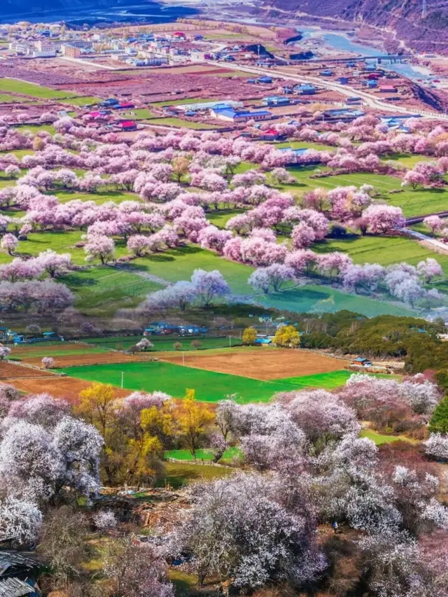 Nyingchi: A Peach Blossom Paradise on the Snowy PlateauIn the distant snowy plateau, there is a land blessed by the heavens, which is Nyingchi, Tibet, a place full of mystery and vitality. Nyingchi, known as the 'Jiangnan of Tibet', is praised for its clear mountains and rivers, mild climate, and distinct seasons, making it more like a magical oasis compared to other regions of Tibet. In spring, when the peach blossoms are in full bloom, Nyingchi turns into a pink ocean. The beautiful scenery of the blooming peach blossoms not only attracts thousands of tourists but has also captivated countless poets and scholars. The great Tang Dynasty poet Du Fu once dreamed of the peach blossoms of Nyingchi in his poems, and though he never set foot there, his heart had already taken flight. Here, every peach blossom seems to tell an ancient tale, narrating the changes of history. Nyingchi is not only enchanting for its natural landscapes but is also one of the important birthplaces of Tibetan culture. The legendary stories of Pangu creating the world and Shennong tasting hundreds of herbs have left deep marks here. The predecessor of the Potala Palace, Tsongzanlin Monastery, is located here, witnessing the prosperity and development of Tibetan culture. Walking through the streets and alleys of Nyingchi, one can feel the strong religious atmosphere and ethnic characteristics everywhere. Every temple, every prayer flag, and every scripture speaks of the devotion to faith. The natural beauty of Nyingchi is even more astonishing. The Yarlung Tsangpo River meanders here, with undulating mountains and swirling clouds, resembling a natural ink painting. Along the Nyang River, wildflowers are everywhere, the grass is green, and yaks and sheep graze leisurely by the river, presenting a peaceful and harmonious pastoral life. Every scene here is like a painting meticulously arranged by nature, bringing peace of mind and making one forget the troubles of the world.GEORGE JIMENEZ
You Might Also Like

Xueying Helicopter Sightseeing
3.8
5/56 Reviews
From €84.98
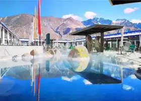
Blue Paradise Yangbajing Geothermal Tourist Area
5.2
4.3/5131 Reviews
-€12.86
From €12.61
Nearby Attractions
Lin Ze Yesheng Mihou Amusement Park | 林拉公路 | 色季拉景區 | Taizhao Ancient Town | Folk Culture Village | Pillar Rock in Midstream | Zhaxiqu Linsi | Tangfan Ancient Path | Apei New Village | Chama Ancient Post | Qudecuo | Mo Longlangcuo | Yucai Library | Qi Bulicuo | Ba Ladongcuo | Xiabu Suolingcuo | Xiezi Guocuo | Qunacuo | Jiabucuo | Baiyugang Cuo | Storehouse Gacuo | Simulang Qu | Cuosong | Jiebucuo | Rennima Cuo | Bagabucuo | Se Muqiancuo | Mengguocuo | Gangduocuo | Yao Jilangcuo
Popular Types of Attractions in Gongbo'gyamda
Nature | Mountains | Lakes | Rivers | Religious Sites | Architecture & Landmarks | Historical Architectures | Observation Decks | Squares | Traditional/Cultural Experiences | Historic Sites | Historical Sites | Palaces | Exhibition Centers | Museums | Exhibition Halls | Fine Art Galleries | Outdoor Sports | Mountain Climbing | Hiking | Lifestyle | Campgrounds | Resorts | Parks
Popular Restaurants in Gongbo'gyamda
Recommended Attractions at Popular Destinations
Bangkok attraction near me | Manila attraction near me | Tokyo attraction near me | Taipei attraction near me | Hong Kong attraction near me | Seoul attraction near me | Los Angeles attraction near me | New York attraction near me | Shanghai attraction near me | Kuala Lumpur attraction near me | Shenzhen attraction near me | Osaka attraction near me | London attraction near me | Singapore attraction near me | Guangzhou attraction near me | San Francisco attraction near me | Beijing attraction near me | Macau attraction near me | Bali attraction near me | Paris attraction near me | Jakarta attraction near me | Ho Chi Minh City attraction near me | Orlando attraction near me | Phuket attraction near me | Toronto attraction near me | Chicago attraction near me | Cebu attraction near me | Seattle attraction near me | Istanbul attraction near me | Dallas attraction near me
Popular Ranked Lists
Popular Premium Hotels in La Cerdanya | Popular Premium Hotels in Scarborough District | Popular Family-friendly Attractions Near Linwu | Popular Premium Hotels in Caylloma Province | Popular Luxury Hotels Near Bartow County | Popular Premium Hotels in Abona | Popular Family-friendly Attractions Near Jingyu | Popular Family-friendly Attractions Near Shangyou | Top 6 Local Restaurants in Okinawa | Popular Premium Hotels in Jekan Raya | Top 5 Premium Hotels in Haut-Rhin | Popular Family-friendly Attractions Near Jiexi | Top 20 Local Restaurants in Berlin | Popular Family-friendly Attractions Near Gaoqing | Top 3 Premium Hotels in Comarca de Oviedo | Top 5 Luxury Hotels in Province of Messina | Popular Family-friendly Attractions Near Tumed Left Banner | Top 6 Premium Hotels in Cete-d'Or | Top 10 Local Restaurants in Kathmandu | Popular Family-friendly Attractions Near Zhenxiong | Popular Luxury Hotels Near Vourvourou | Popular Premium Hotels Near Caracas | Top 7 Bars in Yangshuo | Top 4 Bars in Kanazawa | Popular Family-friendly Attractions Near Manas County | Popular Luxury Hotels Near Rockwall | Top 10 Local Restaurants in Perth | Popular Family-friendly Attractions Near Fengcheng | Popular Premium Hotels in Pemenang
Popular Trip Moments
The mouths of our friends in Nyingchi are really strict! Absolutely stunning!! | Nyingchi Travel Guide | Nyingchi travel, a different experience awaits you! | Nyingchi Travel, these places are a must-visit! | Tibet Travelogue (3) —— Gongbu Jiangda County, Nyingchi | Nyingchi is a great destination for you to visit. | The Nyingchi Peach Blossom Festival in Tibet is coming soon. Are you ready? | 【New Oriental|Holy City of Snow】7 Days and 6 Nights in Lhasa, Tibet. | Nyingchi Basum Tso + Mount Namjagbarwa + Motuo 5-Day Tour | Heavenly Place Basong Lake. | Nyingchi + Basum Lake + Xincuo 3-Day Tour!!! | March·Nyingchi Peach Blossom Festival (Chengdu to Lhasa) | Basum Tso | Basong Tso's Jieba Village | Basum Tso is a must-see, it's so beautiful | The winter Namtso can cure everything! | It is really very beautiful | A long journey dedicated to the distant lands | Please keep this Sichuan-Tibet travel guide well | The Songzan Basongtso Linka Hotel is just too photogenic | Spring Romance in Flower Viewing: The Dreamy Wonderland of Nyingchi | I have a preference for the spring in Linzhi | Peach blossoms are blooming in Gala Village | If you come to Tibet, be sure to stay a night at the Songtsam Hotel | Tibet is back, travel guide for the Linzhi Lai Gu line | The secluded wonderland - Xin Cuo | I really like this simple and unsophisticated feeling | Nyingchi: A Peach Blossom Paradise on the Snowy Plateau | Songzan Basongtso Linka Check-in at the tenth Songzan Hotel | Cuogao Ancient Village | Basum Tso Lake Heart Island
More Things To Do in Gongbo'gyamda
4-Day Lhasa to Nyingchi Private Tour: Pagsom Co, Lamulacuo, Yamdrok Lake | 3-Day Tibet Private Tour: Namcha Barwa Peak, Kading Valley, Yarlung Zangbo Grand Canyon | China eSIM Day Pass/data Package days selected without cards QR code | China Mainland eSIM|China Mobile Unlimited 4G High Speed Data | China·Hong Kong·Macau eSIM|Unlimited 4G High Speed Data | [China Mainland] eSIM | SIM to China | 8GB 8days 4G high speed | Asia・Australia eSIM|AIS SIM2Fly 8 days 6GB High-speed Unlimited 5G/4G Data | Global (66 Countries) eSIM Data Package (QR Code) | Mainland China + Hong Kong + Macau eSIM 4G Data Daily Plan QR Code | Mainland China eSIM |China Mobile 4G high-speed unlimited data eSIM | China/Hong Kong/Macau eSIM 4G high-speed network QR code | eSIM for China, Hong Kong and Macau. Universal for Mainland China/Hong Kong/Macau. Optional days for travel and business. QR code | Mainland China + Hong Kong + Macau eSIM Data Plan QR Code | China, Hong Kong, Macau 4G SIM Card (HK, Macau, Taiwan, China Delivery Only) | Trip.SIM Japan, South Korea, Macau, Taiwan and many places in Asia + Australia and New Zealand 4G travel data roaming phone network card 4 days/7 days | Mainland China eSIM high-speed network QR code | Global multi-region C series eSIM|Common in 84 countries Travel and business Internet access Optional unlimited data Optional days QR code | [FLASH SALE] China, Hong Kong, Macau eSIM - Data plan by Gohub (QR Code) | eSender - Mainland China eSIM daily package/traffic package, days optional. No need to get the card QR code | Asia 9 Destinations eSIM 4G Data Plan QR Code | Global multi-region A series eSIM|High-speed data, travel and business Internet access, optional unlimited data, optional days, QR code | China, Macau eSIM - Data plan by Gohub (QR Code) | China Mainland + Macau 5G/4G eSIM QR Code by China Unicom | 【5G SIM Card】China・National 5G Universal SIM Card |Total 10GB/15GB/30GB/45GB High-speed 5G Unlimited Data Service (Pick up at Shanghai Pudong T2) | Global (30 Countries) eSIM Data Package (QR Code) | China 4G SIM Card (HK, Macau, Taiwan, China Delivery Only) | Global multi-region B series eSIM|Universal in 54 countries Travel and business Internet access Optional unlimited data Optional days QR code | eSender- Brunei/Indonesia/Singapore/Japan and many other countries and regions eSIM daily package/data package (QR code) | Global eSim for 140+ countries (sent via email) by Xplori | Hong Kong eSIM local - Data plan by Gohub (QR Code)
Payment Methods
Our Partners
Copyright © 2024 Trip.com Travel Singapore Pte. Ltd. All rights reserved
Site Operator: Trip.com Travel Singapore Pte. Ltd.
Site Operator: Trip.com Travel Singapore Pte. Ltd.
The scenic spots passing by the Yarlung Zangbo River Grand Canyon Scenic Area can be photographed on the platform, but if you have time, you can stay here for a day. The scenery here is beautiful.
The Niyang River originates from the miscellaneous beams on the west side of the Mira Mountains in the Tibet Autonomous Region, one of the five tributaries of the Yarlung Zangbo River, which is integrated into the Yarlung Zangbo River on the south side of the Bayi Town of Nyingchi. The confluence of the river is clear, the water of the Niyang River is green and clear, and the water of the Yarlung Zangbo River is yellow and turbid, forming the confluence of the river.
20220607 In the evening, 0608 morning: 1. The place is in Nyingchi. After dinner, I go for a walk by the Niyang River to eat. The sandstone by the river is mostly pebbles. The beach that occasionally shows up is like natural paper can write and remember. It is very artistic with the river water backed by the mountains and white clouds. At present, it is the dry season of the Niyang River. From the small puddles by the river, you can see the width of the river during the multi-water season. 2. The next morning, I came to the "Yani National Wetland Park", and there was no bus to drive. "Ya" represents the Yarlung Zangbo River, and "Ni" represents the Niyang River. The first stop of the scenic spot is the "Niyang River Scenery Belt", which is the wetland landscape of the Niyang River before the river meets. 3. The park is composed of a high observation deck and a walking plank road along the river. The viewing platform has a wide view, the blue sky and white clouds in the distance, the blue mountains, the green mountains, the Lijiang River, and the yellow green vegetation along the beach, forming a beautiful colorful picture, and the black cattle that leisurely eat grass are like black stones dotted on the picture. 4, down the stairs to walk along the river boardwalk, you can immerse in the beauty at close range, become a member of the painting, but the photo angle is flat, not as beautiful as the three-dimensional effect of taking pictures at high places. The cattle are free-ranged by the villagers, with "ID card" on the ears, and there are local plants and wild birds along the stairs plank road. The birds and animals live in peace and quiet. Even Premier Li marveled at the beauty when he passed by here and stopped to enjoy the scenery for a long time (the tour guide said). Since the scenery along the river walk path can be seen on the observation deck, I did not take the plank road in the afternoon, and it only took half an hour. 5, a quarter of an hour drive to the second landscape "Benri Scenic Area", the north side of the Benri Shenshan is the birthplace of the native religion of Tibet, often Tibetan believers while walking around the mountain, using blood and flesh to measure its circumference. 6, Benri scenic spot is the intersection of rivers and rivers, the only landscape is Tibet's first glass observation deck, the observation deck can see the magnificent view of the Niyang River into the Yarlung Zangbo River. There is Douyin shooting point on the observation deck, there are statues of men and women (looking like Tibetan women and Qing Dynasty men), and below the observation deck are cruise ship docks, small islands in the river (can't pass, only trees are planted and no bridges), imitation yurts, dining areas and small fountains. 7. It took half an hour to see the Benri scenic spot. You can walk to this scenic spot along the river plank road from the "Niyang River Scenery Belt" just now. The plank road will pass through landscapes such as "Tibetan King Tomb" and "Benri Shenquan". When you wait for the second brush, walk and observe carefully.
Tibet Yani National Wetland Park (also known as Niyang River Scenery Belt), across Nyingchi, Milin two counties, the surface altitude of 2920 meters, the total area is 8,738 hectares. Yani National Wetland Park (also known as Niyang River Scenery Belt), across Nyingchi, Milin two counties, the surface altitude of 2920 meters, the total area is 8,738 hectares. In the vast Yani National Wetland Park, the clear Niyang River flows quietly here, the river branches are crisscrossing and curved. This is a stunning plateau wetland, here is like an epic picture, beautiful people.
I love the blue sky and air.