OverviewBookNearbyReviewsWin PrizesRecommended
Share to
Hoh Xil Nature Reserve
可可西里自然保護區5.9
185 Reviews
Closed Today Open tomorrow at 08:00-17:00(Admission ends at 17:00)
Recommended sightseeing time:1 day
Address:
109 National Road, Golmud City, Haixi Mongolian and Tibetan Autonomous PrefectureMap
What travelers say:
The continuous green mountains and mountains, coupled with the blue sky, are a paradise for wildlife survival, and a place full of "wildness", containing the rich and complete biological gene bank of the Qinghai-Tibet Plateau, but for humans, it is not so easy to step into Cocoa Xili. It is called the "human exclusion zone", and it is rare to see people all year round. Climate change is actually very fast. It will start to be high in the absence of oxygen. If you are lucky, yaks and Tibetan antelopes are numerous, but there are also beasts. Don't get off at will, and brown bears and wolves appear in minutes.
More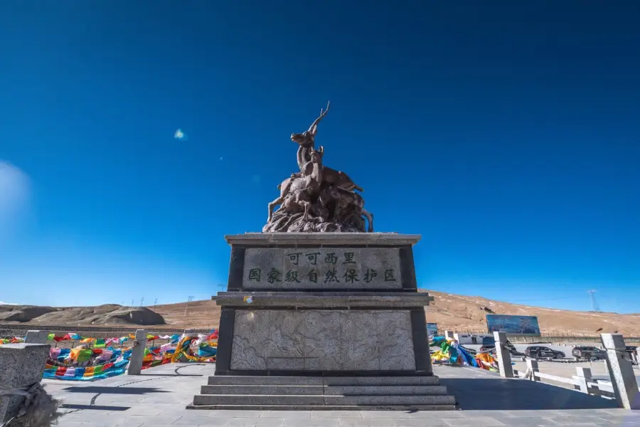
See all 26 photos
Saved by 11
Hoh Xil Nature Reserve Highlights: Must-See Features and Attractions
Some information may have been translated by Google Translate
"HohXil" means "blue mountain ridge" in Mongolian. The Tibetan language calls the area "Achin Gongga". It is one of the areas where the original environment is well preserved, and it is also one of the nature reserves built in China with a larger area, higher altitude and richer wildlife resources. Hoh Xil has a severe cold climate and harsh natural conditions, making it impossible for humans to live for a long time. It is known as a "forbidden zone for life".
Recommendations Near Hoh Xil Nature Reserve
Hoh Xil Nature Reserve Reviews: Insider Insights and Visitor Experiences
Some reviews may have been translated by Google TranslateWrite a Review
/5
Outstanding ReviewsAll (185)
Latest
With Photos (282)
Positive Reviews (178)
Negative Reviews (1)
- 1
- 2
- 3
- 4
- 37
Hoh Xil Nature Reserve Photos: Trip Moments
 Kekexili One-Day Tour👍Highly recommended: The most beautiful scenery is always on the road. Traveling along the Kunlun Mountains and crossing the uninhabited area of Kekexili, I was lucky to see Tibetan antelopes, wild yaks, and Tibetan wolves! ❤Reasons for recommendation: I just want to say: if you don't go there yourself, the scenery will always live in someone else's photos! ✅Must experience: I just finished the Kekexili one-day tour, and the weather, scenery, animals, and people I encountered were unexpectedly beautiful. I was lucky that the weather was clear, the visibility of the Kunlun Dragon's Backbone and various small animals was at its peak. The wind was strong, and the temperature was slightly cold, but it was warm inside the car. The fellow travelers and the guide I met were very nice, and we had a great chat along the way, leaving altitude sickness far behind.WanderBeyondBorders$7
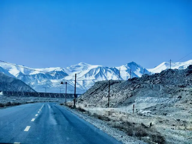
 The places I once longed for in geography books have all become roads I've traveledThe moment the ancestor of ten thousand mountains appeared before my eyes, I couldn't help but marvel at the grandeur of the Kunlun Mountains. Majestic and fortunate to have captured with my eyes the beloved snow-capped Mount Yuzhu, standing at 6178 meters, resembling a lovely girl. Suddenly, I thought of a phrase: 'While everyone heads to the sea, I alone turn to the mountains.' How lucky we are. Traveling with a military convoy tens of kilometers long into the Hoh Xil, we kept a tacit distance and used our turn signals kindly. The beautiful legend is actually a forbidden zone for human life. The grasslands at an altitude of over 4700 meters are a free paradise for all creatures, though I didn't encounter the Tibetan antelopes I longed for, I did come across other adorable animals. The bumpy permafrost highway and the distant Qinghai-Tibet Railway, built by road workers challenging human limits with their lives, left me, who gets dizzy and freezes as soon as I step out of the car and can only breathe oxygen throughout the journey, with nothing to offer but silent salutes and prayers for a lifetime of peace and health. Standing at the source of the Yangtze, Yellow, and Lancang Rivers, I couldn't help but marvel at the magic and greatness of nature. The small streams that eventually become the life-nurturing Yangtze River, the scenes of Sicily from my childhood 'Animal World' and 'Man and Nature' are still vivid in my memory. Now, having the fortune to be here, I am filled with emotion. Life is like this, reminiscing while continuing, never willing to truly stop. I used to like Da Bing's books a lot, and there's a line in his song, 'Accompany me to Hoh Xil to see the sea, I don't want the future, just you to come.' Now I understand that this is probably a naive obsession and madness of youth. Approaching thirty, I came to Hoh Xil and realized there is no sea here; you must live well to have a future with him.marceline_aurelia_silverwood
 Hoh Xil | A Mysterious Realm of Beauty and Death in the Kunlun Mountains.You have entered the homeland of the Tibetan antelope 🐐 Hoh Xil 🤎 China's largest remaining wilderness 🌍 A pure land untouched by human activity 🌍 A sacred place witnessing life and faith 🌈 Route Guide 🌈 ✅ Itinerary: 9 days and 8 nights Qinghai-Gansu Grand Loop (Hoh Xil) 🚩 D1: Departure - Xining - Check into hotel 🚩 D2: Xining - Riyue Mountain (scenic drive) - Qinghai Lake - Chaka Salt Lake - Chaka (overnight) 🚩 D3: Chaka - Qarhan Salt Lake - Golmud (overnight) 🚩 D4: Golmud - Kunlun Sacred Spring - Wuji Dragon and Phoenix Palace - Distant view of Yuzhu Peak - Hoh Xil Tibetan Antelope Viewing Platform - Golmud 🚩 D5: Golmud - Qinghai Yardang - Water Yardang - Dongtai Jinel Lake - 315 U-shaped Highway - Emerald Lake - Dachaidan (overnight) 🚩 D6: Dachaidan - Most Beautiful Road in the Gobi - Oil Town - Silk Road Heritage City - Dunhuang (desert camping) 🚩 D7: Dunhuang - Mogao Caves - Mingsha Mountain Crescent Spring - Shazhou Night Market (drop-off only) - Dunhuang City (overnight) 🚩 D8: Dunhuang City - Son of the Earth - Jiayuguan Pass - Zhangye Danxia National Geological Park - Zhangye (overnight) 🚩 D9: Zhangye - Qilian Mountain Grassland - Distant view of Gangshika Snow Peak - Menyuan Rapeseed Flower Field (seasonal attraction, not visited outside the flowering period: July 10 - August 10) - Xining (end) 🗞 Hoh Xil 🤍 More pure than imagined, on the way from Golmud to Hoh Xil, you will see snow-capped mountains 🏔️, grasslands, lakes, wetlands, blooming wildflowers, and herds of wild animals 🤍 It is an animal paradise, a forbidden zone for human life, a heaven, a hell, a sacred place witnessing life and faith ❤️🔥 💜 Little tips! 1⃣️ The temperature is low in the morning and evening, even in summer, so keep warm 2⃣️ Wear brightly colored clothes for photos, they turn out better 📷 3⃣️ Prepare some altitude sickness medication 💊, just in case 4⃣️ Strictly prohibit any illegal crossing, and do not leave any trash! #Hoh Xil #Qinghai Hoh Xil #Hoh Xil Travel #Qinghai Travel Guide #Gansu Qinghai Grand Loop #Beautiful Qinghai #Qinghai Dunhuang Grand Loop #Qinghai Gansu Travel Grand Loop青甘大环线
 Hoh Xil - A sacred place witnessing life and faith✨Dear treasures, you must visit Hoh Xil! It possesses soul-stirring beauty and unparalleled charm!✨ 🚩Preparations: 🎽Make sure to bring enough warm clothing, as the temperature difference between day and night is huge. 💊Anti-altitude sickness medication is essential; take precautions in advance. 📷Camera, to capture every stunning moment here. 🍫Bring some high-calorie food for energy replenishment. 🚗Travel Itinerary: 🌈Day One: Depart from Golmud, enjoy the magnificent scenery along the way, reach the Kunlun Pass, and feel its grandeur and vastness. 🌈Day Two: Delve into Hoh Xil, visit the Sonam Dargey Conservation Station, learn about the ecological conservation stories of Hoh Xil, and you might even encounter the adorable Tibetan antelope🐐. 🌈Day Three: Continue exploring Hoh Xil, immerse yourself in the endless wilderness, and experience the greatness of nature. 🌟Must-visit spots: 🌄Kunlun Pass: Continuous snow-capped mountains, sacred and spectacular. 👀Sonam Dargey Conservation Station: Get up close with the guardians of Hoh Xil. 💡Tips: 🔸Respect everything here, do not damage the environment. 🔸Do not venture alone into uninhabited areas; always be mindful of safety. It's best to be accompanied by someone experienced or join a professional team. 🔸Move slowly in high-altitude areas to avoid vigorous exercise and prevent altitude sickness. 🔸Keep an eye on weather changes, as bad weather can be dangerous. 🔸Carry a satellite phone or other reliable communication devices to ensure contact with the outside world in emergencies. 🔸When driving in Hoh Xil, be aware of road conditions, as some places may be rugged. 💕Hoh Xil is a place where you can forget all your worries and embark on a dreamy journey of your own!💖ExploringEssence
 Qinghai self-guided tour has checked in for you1️⃣ 📍: Hoh Xil 🚘: Driving route: Golmud - Kunlun Holy Spring - Yuzhu Peak - Kunlun Mountain Pass - Sonandajie Conservation Station, return. 🏞️: High-altitude uninhabited area, pristine nature reserve, World Natural Heritage site. Here you can find towering snow-capped mountains, majestic glaciers, tranquil lakes; it's a paradise for wildlife, with Tibetan antelopes, black-necked cranes, vultures, wild yaks, Tibetan wild donkeys, etc. Also known as: The Forbidden Zone of Life. 🐳: Poor road conditions (requires vehicle passability and power), no supplies (bring your own food), poor signal (download offline maps), high altitude with lack of oxygen and high UV radiation (prepare for cold, sun protection, and altitude sickness), unpredictable weather, respect the dangers! Littering is strictly prohibited! 2️⃣ Devil's Eye 📍: Mangya City, Haixi Prefecture 🚘: Navigate to the Devil's Eye to reach. 🏞️: In the desolate western end of the Qaidam Basin, the never-ending spring water gushes out from the earth, the spring water is a bright yellow-red color, shaped like an eye, as if embedded in the desolate land like the eye of a devil. The tumbling spring water spreads to the surrounding land, accumulating over time, etching the surrounding land into another appearance, indescribably magnificent and colorful, it will always gaze quietly into the deep sky. 🐳: Average road conditions (requires vehicle passability and power), essential to have a drone (no effect without aerial photography)! 3️⃣ Devil's City 📍: Lenghu Town, Mangya City, Haixi Prefecture 🚘: Navigate to the Yadan Landform Group in the Ejin Banner Scenic Area, first to the Mars Camp, and then 500 yuan per vehicle for entry to the scenic area. 🏞️: Ejin Banner, a Yadan landform group, where you can see thousands of miles of rolling yellow sand and fierce westerly winds, a sense of loneliness and insignificance that has nowhere to be placed. The sunset is gorgeous, the night sky is clear, and the Milky Way is brilliant, striking the soul with desolation and grandeur! Mars Camp, this is the place on Earth that least resembles Earth. Space capsules, spacesuits, as if you are on Mars. 🐳: Poor road conditions (requires vehicle power and passability), long-focus photography, aerial photography can have an effect! 4️⃣ 📍: 1. Mangya City, Haixi Prefecture 2. Da Qaidam, Haixi Prefecture 🚘: 1. Navigate to Mangya Emerald Lake, beside the 315 road in Huatugou Town; 2. Navigate to Da Qaidam Town Emerald Lake 🏞️: Both are called Emerald Lakes, although they are hundreds of kilometers apart, each has its own unique beauty, you can choose one or both to see. Comparatively speaking, Mangya Emerald Lake is a bit greener, Da Qaidam Emerald Lake is bluer, and Mangya Emerald Lake is larger overall. The large and small lakes are like gems lost by the fairy world to the human world, dazzling and captivating, making it hard to contain oneself. 🐳: Pay attention to wind and sun protection, aerial photography is recommended if possible. Summary: Qinghai has unique natural landscapes, with Xining and Golmud as the two base cities to expand outward, there are endless beautiful views, you can plan your route according to time.PassionateNomad
 Qinghai Travel: A Journey to Hoh Xil.When you hear the name Hoh Xil, it might sound familiar, but if asked to say something about it, you might find yourself at a loss for words. Hoh Xil means "blue ridge" in Mongolian and "beautiful girl" in Tibetan. It is one of the most well-preserved areas of primitive ecological environment in the world and the last piece of land retaining its original natural state. It is located south of the Kunlun Mountains, spreading across Qinghai and Tibet. Due to its harsh climate and severe natural conditions, humans cannot live there for long periods, but it is a paradise for wildlife. Hoh Xil is a place full of mystery and unknown forces, and only those with a spirit of adventure and exploration dare to venture there. After all, it was once a "forbidden zone" for humans. Hoh Xil is located in the western part of Qinghai Province, covering a total area of 4.5 million hectares. It is one of the best-preserved natural reserves of primitive ecological environment in the early 21st century and one of the largest, highest, and most wildlife-rich nature reserves in China. The intense contrast between the blue sky and the earth here is striking, with no air pollution and very high air transparency, making everything look very clear and often giving a sense of distance illusion. The beauty here is a rugged beauty, especially in the "Double Lakes" area in its heartland, which feels like it is not on Earth. The scenery here far exceeds many people's previous aesthetic experiences. Sharing an eight-day tour route of Hoh Xil: Qinghai-Dunhuang Grand Loop plus Hoh Xil Eight-Day Tour Day 1: Xining—Sun and Moon Mountain—Qinghai Lake—Qinghai Lake—Chaka Day 2: Chaka Salt Lake—Qaidam Basin—Chaerhan Salt Lake—Golmud (overnight) Day 3: Golmud—Distant view of Yuzhu Peak—Wuji Dragon and Phoenix Palace—Kunlun Sacred Spring—Kunlun Pass—Hoh Xil Sonam Dargye Protection Station—Golmud (overnight) Day 4: Golmud—Water Yadan—315 U-shaped Highway—Qinghai Yadan Devil City—Emerald Lake—Dachaidan (overnight) Day 5: Dachaidan—Dangjin Mountain—Akesai Petroleum Town—Yangguan—(recommended desert camping)—Dunhuang (overnight) Day 6: Mogao Caves—Mingsha Mountain Crescent Spring—(recommended Again See Dunhuang)—Dunhuang (overnight) Day 7: Dunhuang—Guazhou—Jiayuguan—Zhangye Danxia Landform—Zhangye Danxia (overnight) Day 8: Zhangye—Biandukou—Qilian Mountain Grassland—Gangshika Snow Peak (distant view)—Menyuan Rapeseed Flower Sea (only in July)—Heiquan Reservoir—Xining (end)青海旅游当地向导祁军
You Might Also Like

Dachaidan Snow Mountain Hot Spring
4.9
4.4/5155 Reviews
From NZD 26.58

Kelukehu Tourism Area
5.5
3.7/5255 Reviews
From NZD 4.51
Nearby Attractions
Golmud River | Kunlun Park | 格爾木NODE星球 | Ge'ermu Ke Xiqingzhen Dasi | Golmud Museum | Jiangjunlou Park | Kunlunshan Dizhi Park Museum | Jichang Garden | qing zang gao yuan | Jinyu Lake | kun lun shan men ji nian bei | Kunlun Garden Square | Golmud Science and Technology Museum | ge er mu ti yu guang chang | Children's Park (Northeast Gate) | Golmud Tourist Attraction | KunLunYu WenHua ChenLieGuan | Ge'ermu River East Great Muslim Temple | san jiang yuan guo jia gong yuan ke ke xi li guan li chu | ge er mu shi di gong yuan | chang jiang mu ge ye she zhang peng ying di | bo ye cheng shi lu ying gang | Tianranju Ecological Garden | Golmud Martyrs' Cemetery | jin yu hu xiu xian pao ma chang | huang he jing guan yuan | qing cang gong lu ji nian guan | hai bin xiao zhen dong man cheng ( shi bang · cheng shi guang chang dian ) | Ge'ermu General Memorial Hall | da lang tao sha shui hui
Popular Types of Attractions in Golmud
Popular Restaurants in Golmud
振華手抓大王 | 青海土火鍋 | 犛牛大骨湯 | 德克士(崑崙路店) | 格爾木高原犛牛退骨肉 | 張家牛雜湯 | 魚你在一起 | 必勝客(格爾木華興店) | 德克士(華興店) | 尕胡才炕鍋烤羊肉館(八一路店) | Ma'erwenshougongsuannaifang | 重慶特色瓦缸烤魚 | SAN JIANG YUAN MEI SHI CHENG | 小龍坎老火鍋(江源南路店) | 青海凱邦大酒店·西餐自助 | Zhonghaoxi'erdunyilinjiudianxicanzizhu (xicanzizhu) | 塞納左岸咖啡(格爾木華興廣場店) | 老字號馬藝黑烤吧 | QING ZHEN LAO ZI HAO LAO MA KAO YANG ROU | 小樹林川菜館 | 玲瓏灣酒店粵秀西餐廳 | 米蘿咖啡(崑崙店) | 洋房火鍋 | XIN JIANG NA MING CHU | BEI GU XING XUAN ZHUAI XIAO HUO GUO | XIN JIANG DA PAN JI WANG DI ER FEN DIAN | DONG BEI NA GA DA | 劉記葫蘆頭 | Caojikang Lamb | Yixinshougongpaozhang
Recommended Attractions at Popular Destinations
Bangkok attraction near me | Manila attraction near me | Tokyo attraction near me | Taipei attraction near me | Hong Kong attraction near me | Seoul attraction near me | Los Angeles attraction near me | Kuala Lumpur attraction near me | Shanghai attraction near me | New York attraction near me | Shenzhen attraction near me | Osaka attraction near me | London attraction near me | Singapore attraction near me | Guangzhou attraction near me | San Francisco attraction near me | Beijing attraction near me | Macau attraction near me | Bali attraction near me | Paris attraction near me | Jakarta attraction near me | Ho Chi Minh City attraction near me | Orlando attraction near me | Phuket attraction near me | Toronto attraction near me | Chicago attraction near me | Cebu attraction near me | Seattle attraction near me | Istanbul attraction near me | Fukuoka attraction near me
Popular Ranked Lists
Top 7 Bars in Cancun | Top 9 Bars in Wuhu | Top 19 Local Restaurants in Athens | Popular Family-friendly Attractions Near Sangri | Popular Premium Hotels in Fuschlsee | Popular Premium Hotels in Moselle | Top 12 Local Restaurants in Yangon | Popular Family-friendly Attractions Near Qushui | Popular Luxury Hotels Near Mlada Boleslav | Top 22 Local Restaurants in Yangzhou | Popular Family-friendly Attractions Near Zhangzi | Top 19 Local Restaurants in Changchun | Popular Family-friendly Attractions Near Yanshan | Top 7 Bars in Izmir | Top 19 Local Restaurants in Moscow | Popular Family-friendly Attractions Near Licheng | Top 20 Local Restaurants in Madrid | Top 17 Local Restaurants in Wenzhou | Popular Premium Hotels in Bacalar | Top 19 Local Restaurants in Los Angeles | Popular Family-friendly Attractions Near Daguan | Popular Premium Hotels in Wujiaqu | Popular Family-friendly Attractions Near Mulei | Popular Luxury Hotels Near Amsterdam | Popular Family-friendly Attractions Near Delingha | Top 19 Local Restaurants in Milan | Top 16 Local Restaurants in Amsterdam | Popular Family-friendly Attractions Near Alxa Right Banner | Popular Family-friendly Attractions Near Ji County
Popular Trip Moments
Qinghai West Journey Day 2 | Less known than the Chaka Salt Lake, it is the largest 'Mirror of the Sky' in China | A summer trip to Qinghai is not complete without a visit to the Xiwangmu Yaochi | Ulan Buh Desert Summer Tour, don't miss the Wusute Water Yadan | Qinghai Travel: A Journey to Hoh Xil. | Qinghai Qarhan Salt Lake. | China is very beautiful, with seventy percent of its beauty in the northwest. | Legendary Northwest | A trip to the Northwest is like half of China. | Lonely Interstellar - The 'Star' in the Desert. | Hoh Xil | A Mysterious Realm of Beauty and Death in the Kunlun Mountains. | If you take the Z6811 to Tibet, you will see | The significance of the live map comes from the Chaka Salt Lake | Qinghai Travel Route Recommendation | Amazing! The dreamy journey and detailed guide to Chaka Salt Lake | Northwest China Travel | Qinghai-Tibet Plateau Big Loop 6 Days 5 Nights Tour Guide | The Chaka Salt Lake is simply stunning, a trip to the secret realm of the sky | Qinghai-Gansu Grand Loop Tour Carpooling and Free Travel. | Write down some words to record my dreamlike journey to the Northwest | Wusute Water Yadan | You can find the Chaka Salt Lake travel guide without leaving the country | Chaka Salt Lake | God ordered a cup of green grape bubble tea | Hoh Xil - A sacred place witnessing life and faith | The Disappeared Lake Jinoer for 3 Years | It's Back Again, Hurry and Visit with Your Loved One | The enchanting Chaka Salt Lake! It's so breathtakingly beautiful! | The Moments are going crazy | It's not abroad | It's the great Northwest!! | Qinghai! The re-emergence of 'Little Maldives' is stunning! | Why is this amazingly cheap place so unvisited? | The Moments are going crazy | It's not abroad | It's the great Northwest | Truly the number one salt lake in Asia! This trip was totally worth it!!! | The Moments are going crazy! It's really not abroad! It's the great Northwest
Popular Travel Types
More Things To Do in Golmud
Private Transfer Service to Qinghai Lake and Chaka Salt Lake from Xining | Private Round-Trip Transfer Service to Chaka Salt Lake from Xining | 4-Day Private Tour in Qinghai: Ashgang Colorful Peaks, Laji Mountain, Chaka Salt Lake, Emerald Lake, The Water Yadan Geopark, West Tignar Lake, 315 Highway | 3-Day Xining Private Tour: Qinghai Lake, Chaka Salt Lake, Emerald Lake, The Water Yadan Geopark, West Tignar Lake, The Jinyintan Grasslands | 8-Day Qinghai Private Tour: Qinghai Lake, Chaka Salt Lake, Koluk Lake Scenic Area, Emerald Lake, Oboliang,Aiken Spring, The Water Yadan Geopark, Cangyangjiacuo Culture Square | 8-Day Qinghai Private Tour: Qinghai Lake,Chaerhan Salt Lake, The Wanzhang Salt Bridge, Kekexili National Nature Reserve, West Tignar Lake, The Water Yadan Geopark, Chaka Salt Lake | 6-Day Qinghai Private Tour: Qinghai Lake, Chaka Salt Lake, Koluk Lake Scenic Area, Emerald Lake, The Water Yadan Geopark, West Tignar Lake, East Tignar Lake, Riyue Mountains | 8-Day Loop Tour in Qinghai and Gansu: Qinghai Lake, Chaka Salt Lake, Koluk Lake, West Tignar Lake, Aiken Spring,West Tignar Lake, Oboliang, Oil Town, Mogao Grottoes, Mingsha Mountain Crescent Spring | China eSIM Day Pass/data Package days selected without cards QR code | China Mainland eSIM|China Mobile Unlimited 4G High Speed Data | China·Hong Kong·Macau eSIM|Unlimited 4G High Speed Data | [China Mainland] eSIM | SIM to China | 8GB 8days 4G high speed | Asia・Australia eSIM|AIS SIM2Fly 8 days 6GB High-speed Unlimited 5G/4G Data | Global (66 Countries) eSIM Data Package (QR Code) | Mainland China + Hong Kong + Macau eSIM 4G Data Daily Plan QR Code | Global (30 Countries) eSIM Data Package (QR Code) | eSIM I series in multiple regions around the world | High-speed Traffic for tourism and business Internet access, unlimited Traffic, optional Days, QR code | 【5G SIM Card】China・National 5G Universal SIM Card |Total 10GB/15GB/30GB/45GB High-speed 5G Unlimited Data Service (Pick up at Shanghai Pudong T2) | [China, Hong Kong and Macau] CMCC SmarTone CTM | 5G daily data Traffic| 24-hour billing | 3-30 days | Uninterrupted network support hotspot sharing | eSIM | Asia 9 Regions eSIM 4G Data Daily Plan QR Code | AIS SIM2Fly Global eSIM|15 days 6GB high-speed 4G/5G Unlimited Data | China Mainland + Macau 5G/4G eSIM QR Code by China Unicom | eSIM for China, Hong Kong and Macau. Universal for Mainland China/Hong Kong/Macau. Optional days for travel and business. QR code | Global multi-region B series eSIM|Universal in 54 countries Travel and business Internet access Optional unlimited data Optional days QR code | eSender - Mainland China eSIM daily package/traffic package, days optional. No need to get the card QR code | eSender- Brunei/Indonesia/Singapore/Japan and many other countries and regions eSIM daily package/data package (QR code) | Mainland China + Hong Kong + Macau eSIM Data Plan QR Code | China 4G SIM Card (HK, Macau, Taiwan, China Delivery Only) | China, Hong Kong, Macau 4G SIM Card (HK, Macau, Taiwan, China Delivery Only) | Global eSim for 140+ countries (sent via email) by Xplori
Payment Methods
Our Partners
Copyright © 2024 Trip.com Travel Singapore Pte. Ltd. All rights reserved
Site Operator: Trip.com Travel Singapore Pte. Ltd.
Site Operator: Trip.com Travel Singapore Pte. Ltd.
The continuous green mountains and mountains, coupled with the blue sky, are a paradise for wildlife survival, and a place full of "wildness", containing the rich and complete biological gene bank of the Qinghai-Tibet Plateau, but for humans, it is not so easy to step into Cocoa Xili. It is called the "human exclusion zone", and it is rare to see people all year round. Climate change is actually very fast. It will start to be high in the absence of oxygen. If you are lucky, yaks and Tibetan antelopes are numerous, but there are also beasts. Don't get off at will, and brown bears and wolves appear in minutes.
Well, Cocosili, my lips are purple, there is no ancient person before and no one after the appearance, he is so lonely walking, but still in May snow, can not find the feeling of loneliness in the snow, there are people traces of snow, lonely smoke billowing
A film of "Cocoa Xili" let the public truly understand the cruel environment of Cocoa Xili, in order to protect the wild Tibetan antelope, how many people have paid their lives here, no sale and no killing.
Wide and spectacular, although the altitude sickness is serious, but it is refreshing
"Coco Xili (Area)" is the Coco Xili Mountains and their nearby basins and hilly areas, mainly in Qinghai Province and northern Tibet, and a small part in Xinjiang, basins: there are East Coco Xili Basin in Qinghai Province, West Coco Xili Basin in Tibet (called Yanghu Basin), The Kumukule Basin in Xinjiang, etc., is the Puruogang Ri - Tibetan-colored Gangri in the southern end of the Tibetan region.