OverviewBookNearbyReviewsWin PrizesRecommended
Share to
Wucai Qianshan Riverside Pathway
舞彩淺山濱水國家登山步道3.1
19 Reviews
Temporarily Closed Opening hours TBD
Recommended sightseeing time:1-3 hour
Address:
Mulinzhen, Shunyi, Beijing, ChinaMap
What travelers say:
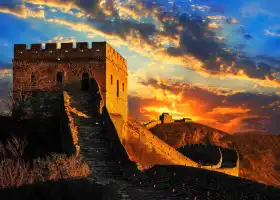
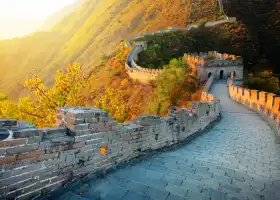
The Dance Cai shallow mountain and waterfront National Mountaineering Trail (Longwantun Section) starts from the east side of Xinzhuang Village in the mountains and west to the dumpling ditch (border with Mulin Town). The first phase is 80 kilometers long, of which the main line is 60 kilometers and the branch line is 20 kilometers. It mainly reflects the characteristics of "waterfront, quiet forest, culture, expansion, original ecology".
More
See all 8 photos
Wucai Qianshan Riverside Pathway Highlights: Must-See Features and Attractions
Some information may have been translated by Google Translate
Wucai Shallow Mountain Waterfront National Hiking Trail (Longwantun Section) starts from the east side of Xinzhuang Village in Shanli in the east and ends at Tarzigou (bordering Mulin Town) in the west. The total length of the first phase is 80 kilometers, with a main line of 60 kilometers and a branch line of 20 kilometers.
Recommendations Near Wucai Qianshan Riverside Pathway
Wucai Qianshan Riverside Pathway Reviews: Insider Insights and Visitor Experiences
Some reviews may have been translated by Google TranslateWrite a Review
/5
Excellent ReviewsAll (19)
Latest
With Photos (26)
Positive Reviews (16)
Negative Reviews (1)
- 1
- 2
- 3
- 4
You Might Also Like

Universal Beijing Resort
10
4.5/525656 Reviews
-NZD 7.88
From NZD 123.41
Badaling Great Wall
9.3
4.7/540499 Reviews
From NZD 9.01
Prince Kung's Palace Museum
8.9
4.7/520110 Reviews
From NZD 9.01
Mutianyu Great Wall
8.4
4.8/519484 Reviews
From NZD 10.14
Nearby Attractions
Universal Beijing Resort | The Palace Museum | National Museum of China | Summer Palace | Prince Kung's Palace Museum | Temple of Heaven | Yuanmingyuan Park | Beijing Zoo | Tiananmen Square | China Science and Technology Museum | Beijing Olympic Park | Bird's Nest (National Stadium) | Yonghe Temple | Chinese People's Revolutionary Military Museum | Shichahai | Jingshan Park | National Natural History Museum of China | The Geological Museum of China | Happy Valley Beijing | Beijing Aquarium | Beijing Planetarium | National Center for the Performing Arts | Nanluoguxiang | Beihai Park | Fragrant Hills Park | Water Cube (National Aquatics Center) | Beijing Auto Museum | Beijing World Park | 【北京】劉德華2024《今天…is the Day》巡迴演唱會 | Tiananmen Rostrum
Popular Types of Attractions in Beijing
Parks | City Parks | Children's Play Areas | Botanical Gardens | Architecture & Landmarks | Historical Architectures | Squares | Featured Neighborhoods | Exhibition Centers | Museums | Fine Art Galleries | Memorial Halls | Lifestyle | Libraries | Resorts | Campgrounds | Nature | Mountains | Forests | Lakes | Historic Sites | Historical Sites | Cemeteries | Ancient Pagodas | Fitness | Stadiums | Billiards | Badminton Courts | Religious Sites | Temples
Popular Restaurants in Beijing
TIDU | BeiJing Quanjude Roast Duck | Wolfgang’s Steakhouse | Rive Gauche | Gastro Esthetics DaDong | IL RISTORANTE NIKO ROMITO | The Peninsula Beijing · Jing Restaurant | 有術cafe studio | Celestial Court | Xin Rong Ji (Xinyuan South Road) | MIO | Cai Yi Xuan | Huguosi Restaurant Xicheng | Hongyuan Nanmen Hot Pot (Temple of Heaven Branch) | Sheng Yong Xing (Chaoyang) | 門框衚衕百年鹵煮(新街口店) | Beijing Palace Garden Hotel Beiqing·Taihefu Buffet Restaurant | Fu Chun Ju | 三清潭燒鵝(太古裏店) | VEGE WONDER | Café Zi | Char bar&grill | LU YU | Living Room | Jingji | King's Joy | Daccapo | Refer | Café Cha | Summer Palace @ China World Hotel
Recommended Attractions at Popular Destinations
Bangkok attraction near me | Manila attraction near me | Tokyo attraction near me | Taipei attraction near me | Hong Kong attraction near me | Seoul attraction near me | Los Angeles attraction near me | Kuala Lumpur attraction near me | Shanghai attraction near me | New York attraction near me | Shenzhen attraction near me | Osaka attraction near me | London attraction near me | Singapore attraction near me | Guangzhou attraction near me | San Francisco attraction near me | Beijing attraction near me | Macau attraction near me | Bali attraction near me | Paris attraction near me | Jakarta attraction near me | Ho Chi Minh City attraction near me | Orlando attraction near me | Phuket attraction near me | Toronto attraction near me | Chicago attraction near me | Cebu attraction near me | Seattle attraction near me | Istanbul attraction near me | Fukuoka attraction near me
Popular Ranked Lists
Top 8 Bars in Cape Town | Top 6 Premium Hotels in Chaozhou | Popular Family-friendly Attractions Near Dai County | Top 3 Premium Hotels in Yongtai | Top 7 Premium Hotels in Liangshan Prefecture | Popular Family-friendly Attractions Near Wugong | Popular Family-friendly Attractions Near Dacheng | Top 19 Premium Hotels in Huizhou | Popular Premium Hotels Near Calcasieu Parish | Popular Luxury Hotels Near Koprivshtitza | Popular Family-friendly Attractions Near Dingxiang | Popular Luxury Hotels Near Sao Joao da Pesqueira | Popular Family-friendly Attractions Near Yangqu | Top 19 Local Restaurants in Toronto | Popular Family-friendly Attractions Near Yongqing | Popular Luxury Hotels Near Ampelokipoi-Menemeni | Top 21 Local Restaurants in Xiamen | Popular Family-friendly Attractions Near Changwu | Top 19 Local Restaurants in Munich | Top 7 Luxury Hotels in Kedah | Popular Premium Hotels in Sanjiang | Top 10 Local Restaurants in Riyadh | Top 3 Premium Hotels in Chengmai | Popular Premium Hotels in Kumano | Top 10 Local Restaurants in Brisbane | Popular Luxury Hotels Near Travemunde | Popular Family-friendly Attractions Near Changji Prefecture | Popular Family-friendly Attractions Near Xingping | Popular Family-friendly Attractions Near Zigui
Popular Trip Moments
Beijing Temple of Heaven Tiantan Is Stunning 🇨🇳 | Amazing Yongding Pagoda 🛕 | Beijing Night Market | The summer fireworks atmosphere at Jiuxianqiao is all here! | The refreshing valley in the suburbs of Beijing is not only cool but also thrilling and exciting | Beijing has its own Southern France holiday paradise! Super beautiful! | Beijing Hotel | An artistic hotel at the foot of the Forbidden City, worth it! | Shijiazhuang Corner in Beijing | A Cool Summer Retreat | Beijing's Most Beautiful Bookstore with an Aerial Walkway | The sandy road is long and the ancient relics remain, the stone pagoda stands tall, known as Yan Dun | Beijing! Tiantongyuan! High-quality cost-effective hotel recommendation! | In Beijing, I visited a detached villa with my boyfriend 5 times | The Splendid Central Axis | Dong Jiao Min Xiang | Beijing's super romantic Hutong citywalk | Phoenix Commune Center Beijing 🇨🇳 | It's no longer a secret that just 2 hours from Beijing, you can find yourself at what seems like the Grand Canyon | Strolling in Beijing·Shichahai/Yandai Xiejie/Bell and Drum Towers | A century of integrity in Beijing craftsmanship, the artisan spirit of Long Shuncheng is passed down | Beijing! Just checked out! So comfortable to stay! Will come again next time! | The upcoming Shichahai will dazzle the entire summer!! | In Tongzhou, don't forget to visit here after enjoying the Universal Studios | Enjoy a beautiful time at the Marriott Hotel on a suburban tour in Yanqing, Beijing | Did you know about the free park at Universal Studios that nobody seems to be aware of? | Fun Day at Universal Beijing Resort in China 🇨🇳 | Check into the wizarding dorm near Universal Studios! | Summer Outing to an Exhibition | Jojo Rabbit Public Art Exhibition Free and with Photos | The Prince Gong's Mansion is swarming with tour groups | My bestie and I enjoyed an unlimited stay at an affordable hotel in Beijing | Beijing has 8 'Destination in Itself' Hotels! | He Guang Book Academy Museum | Stayed at the Grand Hyatt Beijing for the third time
Popular Travel Types
More Things To Do in Beijing
China eSIM Day Pass/data Package days selected without cards QR code | Beijing Mutianyu Great Wall Day Tour by BusDA [8:00/9:00/10:00] | Beijing Prince Gong Mansion one-day tour[Beijing Champion Brand guide In-depth Explanation Including admission ticket Boutique 20-person Group/Individual Group Optional] | Beijing Badaling Great Wall One-Day Tour [Bus to attraction Special Line 7/8/9/10/11/12/Night Tour of the Great Wall Multiple Departures] | China&Hong Kong&Macau&Taiwan eSIM Day Pass/data Package (QR code) | Beijing Temple of Heaven + Hall of Prayer for Good Harvests + Circular Mound + Echo Wall Day Tour [Includes Temple of Heaven Ticket/Small Group Optional/Beijing No. 1 Guide Group Leads You to Visit the Temple of Heaven in Depth] | The Forbidden City Half-day Tour | Beijing Mutianyu Great Wall Day Tour | Mutianyu Great Wall Day Tour | Beijing Palace Museum + Prince Gong's Mansion One-Day Tour [Must-Take the Forbidden City Tour to Explore the Secrets of Prince Gong's Mansion, Three Wonders and One Treasure, Beijing No. 1 Scholar Guide Explanation, Gift Treasure House] | Beijing Temple of Heaven one-day tour[Including Tickets - Including Branded guide Lectures / Say Goodbye to Reservation Troubles / Including - Hall of Prayer for Good Harvests - Circular Mound - Echo Wall] | Trip to Mutianyu Great Wall by Zanbus (08:00/10:00) | Beijing Summer Palace Entrance Ticket (with Optional Guided Service) | Beijing Lama Temple Half-Day Tour [Prayer Line Beijing Champion Guide takes you into Lama Temple to explain the story of the Dragon Hiding Blessed Land] | Beijing Private Tour to Summer Palace and Botanical Garden | Private Night Tour: Beijing Illuminated with Dim Sum Dinner | Layover Self-Guide Tour To Forbidden City with Private English Speaking Driver | Private Night Tour: Discover Beijing in Bustling Lights | All Inclusive Tour to Forbidden City,Tiananmen Square and Hutong | Private Unrestored Great Wall Hiking Tour from Gubeikou to Jinshanling | All Inclusive Private Day Trip to The Western Qing Tomb from Beijing | Private Layover Day Trip to Mutianyu Great Wall From Capital Airport | Beijing Layover Tour to Forbidden City with Peking Duck Dadong Lunch | The Best of Hengyang Walking Tour | Beijing Private Tour: Mutianyu Great Wall & Viewing Forbidden City from Jingshan | Mutianyu Great Wall Trip With English Speaking Driver | Beijing Roast Duck Dining & Acrobatic Show w/ Transfer | 6-Day Private China Highlights Tour from Xi'an: Beijing, Shanghai and Guilin | Gubeikou To Jinshanling Great Wall Private Hiking Day Tour | Xinjiang Silk Road Impression Dining Experience with Houhai Lake and Yandai Xie Street
Payment Methods
Our Partners
Copyright © 2024 Trip.com Travel Singapore Pte. Ltd. All rights reserved
Site Operator: Trip.com Travel Singapore Pte. Ltd.
Site Operator: Trip.com Travel Singapore Pte. Ltd.
The Dance Cai shallow mountain and waterfront National Mountaineering Trail (Longwantun Section) starts from the east side of Xinzhuang Village in the mountains and west to the dumpling ditch (border with Mulin Town). The first phase is 80 kilometers long, of which the main line is 60 kilometers and the branch line is 20 kilometers. It mainly reflects the characteristics of "waterfront, quiet forest, culture, expansion, original ecology".
Very good place, spring, summer and autumn can go, free, and formal parking. We went in early April, because the epidemic has not been unblocked, we are not allowed to enter, the surrounding restaurants are not open, rapeseed has just been planted, everyone will come back later.
The dance color shallow mountain waterfront national mountaineering fitness trail, the fitness trail is divided into parent-child trails, leisure trails, adventure trails, science trails, health trails, expansion trails, red trails. It is very convenient to go to the dance color shallow mountain. Take the subway line 15 and get off at the exit of C2. Down the 36th road to the terminal tea shed, to the gate of the scenic spot, the scenic spot is free of charge.
It looks good, it is a bit far away! ! ! ! !
A good place for mountaineering - Beijing Shunyi Dance color shallow mountain and waterfront country mountaineering trail. This Beijing's longest and domestic first-class mountaineering fitness trail core section, from the east to the Shunyi District Longwantun Town Amway Longshan Villa south side, west to the Mulin Town Tangzhishan Reservoir Dam west side, southeast to northwest direction, the width of an average of two meters, the average slope 38 degrees, the maximum slope 70 degrees. The highest altitude is 555 meters and the lowest altitude is 53 meters. The mountaineering trail includes the main line and the branch line, which mainly connects the shallow mountains of the two towns in series, and the branch line is distributed with more beautiful scenery. For example, the magic fairy cave and the lock wind tunnel are located on the branch line of the mountain trail. Although it is not easy for tourists to reach it, the iron ladder built on the mountain stone will definitely be impressed by the magnificent landscape there.
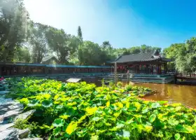
Located at the entrance of the scenic spot, at the entrance of the waterfront trail of the dumpling ditch. Flowers, lakes, rockery and distant mountains echo each other, forming a rich depth of scenery. The dumpling ditch waterfront trail is a boutique route for the National Mountaineering Fitness Trail in the Dance Cai shallow Mountain, which is about 2 kilometers long.