OverviewBookNearbyReviewsWin PrizesRecommended
Share to
wu sun gu dao
烏孫古道5.1
4 Reviews
Recommended sightseeing time:1-2 days
Address:
阿克蘇地區拜城縣Map
What travelers say:
Wusun Ancient Road from Qiongkushitai Village in the north, to Heiyingshan Township in Baicheng County (also can be reversed), the whole journey is about 130km, on the way, it will overturn the snow-capped mountains, overturn the board, cross the virgin forest, the ice river, and the blue lake ....... Difficulty and scenery. Known as Xinjiang's "top landscape trail", it is called Xinjiang's three top hiking routes, along with Xiate Ancient Road and Wolf Tower.
More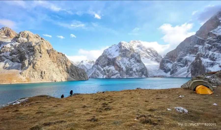
See all 3 photos
Saved by 2
Recommendations Near wu sun gu dao
wu sun gu dao Reviews: Insider Insights and Visitor Experiences
Some reviews may have been translated by Google TranslateWrite a Review
/5
Outstanding ReviewsAll (4)
Latest
With Photos (2)
Positive Reviews (4)
wu sun gu dao Photos: Trip Moments
 The word 'stunning' is seldom used to describe a placeI have been to many places in China, but this one has left the deepest impression on me. From North Xinjiang to South Xinjiang, it takes a week of trekking. These days have truly shown me the vastness of Xinjiang's territory. Every step reveals a scene that is incomparable to any other man-made sight. If you have the chance to come to Xinjiang, you must take a walk on the ancient Wusun trail. If you cannot trek, I also recommend you visit the starting point of the Wusun trail, the Qiongkushitai to see for yourself.Isabella901_Miller
 If you don't go to the Wusun Ancient Trail now, you won't have the chance anymore! Because next year🚧Next year the Wusun Ancient Trail will be open to traffic! The Wusun Ancient Trail, as challenging as the Wolf Tower and Shatuo, will become history! 😱 🤯The mysterious veil of the Wusun Ancient Trail will be completely lifted, revealing itself to everyone. What it will become, once a sparsely populated area with well-preserved natural ecology, is unknown to us. 🤐But one thing is for sure, it will definitely be very different from now! So, if you don't go to the Wusun Ancient Trail now, you really won't have the chance anymore! 👈👈👈 ✨There is less than a month left for the best hiking time on the Wusun Ancient Trail this year! 🎈 📢Best hiking season: Early September (National Day is the last session) 📣Precipitation increases in September, and flowers bloom more luxuriantly. In the past, the temperature started to drop in late September, but this year it has already snowed in early September, so be sure to bring warm clothing such as down jackets, fleece clothes, and stormwear. 🧥 🚶Recommended route: D1: Gather in Yining from all over the country D2: Yining - Qiongkushitai Pastoral Village - Qiongkushitai Valley Campsite (10km) D3: Qiongkushitai Valley Campsite - Qiongdaban - Kunuosayi Campsite (20km) D4: Kunuosayi Campsite - Liusu - Koksu River Campsite (19km) D5: Koksu River Campsite - Kokalarpiye Valley Entrance - Heaven Lake (Akkukule Alpine Lake) (20km) D6: Heaven Lake (Akkukule Alpine Lake) - Erhu - Akbulakdaban - Bozkekrijige Valley (20km) D7: Bozkekrijige Valley - Heiying Mountain Township - Kuqa (32km) D8: Kuqa - Free return trip 📌Tip: After the road opens next year, it will lead directly to Heaven Lake. The current Heaven Lake is rarely visited, with blue waters shining like gems, and the natural environment is well preserved. But what it will become after the road opens is unknown, so hurry up and take the time to see it! 🙏 ⚠Precautions: 📱On the first day of hiking the Wusun Ancient Trail, about 1 hour after leaving the village, there will be no network, and there will be no signal throughout the journey until the last day when you come out of the mountains. However, the leader will be equipped with a satellite phone. 🦁The Wusun Ancient Trail is currently quite primitive, with many rugged and perilous paths along the way. It is best to follow a professional leader and not to act alone. 🥯The whole journey is a light trek, totaling 121km, with great physical exertion. It is recommended to carry high-calorie foods such as beef jerky and chocolate. 🗻The average altitude of the Wusun Ancient Trail is 2500 meters, with almost no altitude sickness. However, the altitude of the campsites on D5 and D6 is above 3000 meters, where you may experience mild altitude sickness, but it's not a big problem, just relax. The time left to hike the Wusun Ancient Trail this year is running out! The next time you come, it might be when the Wusun Ancient Trail is open to traffic! 🚌A rare opportunity, not to be missed! Now recruiting teammates, let's go! 🎉ADRIANA STONE
 The Ancient Wusun Road: Exploring the Secret Land in the Long River of HistoryThe Ancient Wusun Road, this old passage that runs through Xinjiang, has witnessed countless historical vicissitudes. It is a trade route connecting the East and the West, and also a mysterious journey pursued by explorers. Today, let's walk into this ancient road together and feel the long-sealed historical atmosphere. The Ancient Wusun Road is located in the Aksu region of Xinjiang, starting from Tashkurgan in the Kashgar region and ending in Tekes in the Ili region. Along this ancient road, you can enjoy the magnificent scenery and rich historical culture. Stepping on the Ancient Wusun Road is like going through a time tunnel. Here, you can see unique natural and cultural landscapes. Majestic snow mountains, deep canyons, vast grasslands, and those historical and cultural relics scattered on the ancient road, all are carved by time with unique charm. I was fortunate to have walked this ancient road myself, and the scenery along the way was intoxicating. From the glacier meltwater in Tashkurgan to the grassland songs in Tekes, the Ancient Wusun Road interprets the beauty of Xinjiang in its unique way. During the journey, I met many friends from different places, we shared the joy of exploration together, and left unforgettable memories. The Ancient Wusun Road is an unforgettable journey, it uses the dual charm of history and nature to let us feel the fun of exploration. On this ancient road, we not only appreciate the magnificence of nature, but also find a tranquility in the depths of our hearts. Whether you are a history lover or a nature explorer, the Ancient Wusun Road will bring you an unforgettable experience. Step into the Ancient Wusun Road, feel the vicissitudes of history and the magnificence of nature, and let your soul be baptized and sublimated on this ancient road. Come and join us, follow the footsteps of the Ancient Wusun Road, and check in this secret land hidden in the long river of history!lumielle_3952
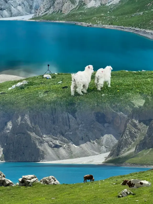
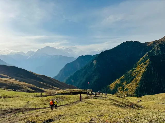
 Wusun Ancient Trail, a treasure secret realm exclusively for hiking enthusiasts✨The coolest hiking route in Xinjiang🎈 (Wusun Ancient Trail) || Route Classification 🚶Hiking Level: Heavy gear 8.5 level🎒, light gear 5 level, highest altitude 3900👀, maximum altitude difference: 1900 📅Hiking Days: 6 days 😎Wusun Ancient Trail itinerary as follows: D1💗Urumqi - Yining City (It is recommended to take the night train🚂) 🛏Accommodation: Train D2🥪Yining City - Tekes - Qiongkushitai 🌮Gather in Yining, after breakfast take a chartered car to Tekes County, drive: 2.5 hours. Have lunch🥘 in the Bagua City, continue to Qiongkushitai Village【Starting point of the hike】, drive: 3 hours. 👉Breakfast: Yining City/Lunch: Bagua City/Dinner: Qiongkushitai 🛌Overnight: Qiongkushitai log cabin D3🚶Qiongkushitai - Log Cabin Campsite (Hike 15 kilometers) 😜After breakfast, follow the Qiongkushitai River upstream, there is a clear horse trail👣, the slope is gentle, herds of cattle and sheep along the way, log cabins scattered. Arrive at the log cabin campsite at an altitude of 2550 meters, with a water source. 🤔Today's difficulty: Level 3 Elevation gain: 850 🛌Overnight: Log Cabin Campsite D4🧗♀️Log Cabin Campsite-Baozadun Pass- Kuokesu River Campsite (Hike 20 kilometers) 👣Depart from the log cabin, continue upstream along the Qiongkushitai River valley, will cross several scree slopes😎, in the afternoon you can see the azure sky above the snow line. Cross the Baozadun Pass, stand on top of the pass to feel the grandeur of nature😍, then follow a small path down Qiongdaban. A few hours later, arrive at the Kuokesu River valley to camp, with a water source. 😤Today's difficulty: Level 7 Elevation gain: 800 Descent: 1600 🛌Overnight: Kuokesu Campsite D5😜Kuokesu River Valley - Zip line across the river - Akebulake Forest Management Station (Hike 20 kilometers) 🎉The biggest task today is to zip line across the Kuokesu River, super thrilling🎊 (There is a simple store at the zip line~ for resupply) After crossing the new bridge, start crossing the river 7 times (you can ride a horse across the river) Difficulty level 7, Elevation gain 700 🛌Overnight: Akebulake Forest Management Station Campsite D6🤩Akebulake Forest Management Station - Paradise Lake (Hike 13 kilometers) 😎Today's journey is the most relaxed, follow the Akebulake River valley upstream, pass through high mountain pastures🐄, then gradually climb in altitude, follow the horse trail uphill, the scenery is desolate. Surrounded by mountains, a turn, and Paradise Lake suddenly appears in front of you, like a sapphire nestled among the mountains. Paradise Lake, also known as Akekule Lake, has a surface altitude of 3100 meters, a length of 6600 meters, and the widest point is 1900 meters, tonight camp by the lake. Difficulty: Level 5 Elevation gain: 500 🛌Overnight: Paradise Lake Campsite D7🤨Paradise Lake - Akebulake Pass【Altitude 3900】- Bozkek Jirge Valley (Hike 25 kilometers) 🎈Bypass the lake, cross the steep Akebulake Pass from the south shore of Paradise Lake, you can look back at Paradise Lake, bid farewell to it. After descending the pass, through many loose stones, enter the Boaozkeklik River valley to camp. 🛌Overnight: Bozkeklik River Valley Campsite D8🚶Bozkek Jirge Valley - Heiying Mountain Township (End of the 27-kilometer hike) -- Kuche (You can take the train back to Urumqi the same night) 🎈Break camp from Bozkekerg Valley, continue to descend along the valley, the route is mainly gentle slopes and downhill. Along the way, you have to wade through the river nearly thirty times, the river is deep, and the current is rapid, some water levels reach the waist. Continue forward, exit the trumpet-shaped Heiying Mountain pass, end the hike, and take the shuttle vehicle to Kuche County. D9🚂Kuche--Urumqi【Train or Airplane】~Various placesGraceBeaumont78
 Journey to the Paradise Lake on the Ancient Wusun Road: Step on the Silk Road and explore the paradise of ice and fireJoin us on a unique winter hiking trip on the ancient Wusun Road in Xinjiang! Here, you will appreciate the magnificent snow mountains, tranquil lakes, dense forests, and rich Wusun culture. Pack your bag, put on your thick winter clothes, and embark on this unforgettable journey together!🏞️❄️ 1️⃣ About the Ancient Wusun Road: The Ancient Wusun Road was an important passage connecting the ancient Wusun and Kucha countries, with a total length of about 130 kilometers, crossing the Tianshan Mountains, connecting the Ili River Valley and the southern Xinjiang Tarim Basin. This is a paradise for outdoor hiking enthusiasts, attracting many explorers to challenge every year.👣🏔️ 2️⃣ The unique charm of the Wusun Ancient Road in winter: The Wusun Ancient Road in winter has a different flavor, with snow-covered mountains, frozen lakes, and rime landscapes, forming a beautiful picture. Here, you can experience the perfect blend of ice and fire and feel the magical charm of nature.❄️🔥 3️⃣ The winter beauty of Paradise Lake: Paradise Lake is the pearl on the Wusun Ancient Road. The lake is clear and surrounded by snow mountains. In winter, the lake freezes and becomes an excellent place for ice skating and snow scene shooting. When the sun shines on the lake, it sparkles with dazzling light, as if taking you into a fairyland.🌞🌊 4️⃣ Hiking guide: - Route: The Wusun Ancient Road is about 130 kilometers long, divided into light hiking and heavy hiking. Choose the route that suits you according to your physical fitness and experience. - Itinerary: It usually takes 6-7 days, and you need to cross two passes along the way, with the highest altitude of 3720 meters. Arrange your itinerary reasonably, pay attention to rest and keep warm. - Equipment: Winter hiking requires warm clothing, waterproof gloves, trekking poles, ice claws, and other equipment. Also, carry enough food and water to ensure safety. - Guide: To ensure safety, it is recommended to hire a local guide with rich experience to lead, familiar with the route and deal with emergencies.🎗️👨👩👧👦 5️⃣ Precautions: - The climate on the Wusun Ancient Road in winter is cold, pay attention to keeping warm and prevent altitude sickness. - The signal along the way is poor, inform your family and friends of your itinerary in advance to ensure safety. - Respect local customs and habits, protect the environment, and do not litter.🌍💡 Stepping on the winter journey of the Wusun Ancient Road to Paradise Lake, you will gain unforgettable memories! In this winter hiking trip, feel the magnificence of nature and the charm of Wusun culture, and it will become an unforgettable chapter in your life!🎉🏔️❄️ExpeditionEuphoria
 Step into the Wusun Ancient Trail and experience the grandeur of a historical epic lost to the worldDear travelers, today I am going to take you into a dusty river of history to explore the mysterious and enchanting Wusun Ancient Trail. This is a millennium-old path that connects the Chinese civilization with the culture of the Western Regions, bearing the traces of vicissitudes of time, hiding countless legendary stories, waiting for us to unveil its veil. Attraction Introduction: The Wusun Ancient Trail, located within the Xinjiang Uygur Autonomous Region, is one of the important passages of the ancient Silk Road. Along the way, there are both majestic Tianshan snow peaks and rippling alpine lakes, as well as rolling grasslands and vast Gobi deserts. Among them, the boundless expanse of the Kalajun Grassland, the rugged beauty of the Shat Ancient Trail, and the primeval forests of Qiongkushitai are all masterpieces of nature's craftsmanship, each radiating a strong historical charm and natural allure. Itinerary: Day 1: Arrive in Urumqi, rest and adapt, prepare supplies. Day 2-3: Head to Zhaosu County, visit the Heavenly Horse Culture Park, then drive to the Kalajun Grassland, experience the joy of horse riding on the grassland, stay overnight in a herdsman's home, and experience nomadic life. Day 4-5: Enter the Wusun Ancient Trail hiking area, cross the Bingdaban along the ancient trail, admire the snow-capped mountains and lakes, visit historical sites along the way, camp at night, gaze at the starry sky, and enjoy the beauty of silence. Day 6-7: Continue hiking to the Shat Ancient Trail, appreciate the canyon scenery, feel the hardships and glory of the ancient Silk Road, and finally return to Urumqi. Transportation Tips: After flying to Urumqi from all over the country, you can choose to rent a car for a self-driving tour or take a long-distance bus to Zhaosu County. After entering the Wusun Ancient Trail, some sections require hiking. It is recommended to contact local travel agencies in advance and be led by professional guides to ensure safety. Also, due to the special environment of the ancient trail, be sure to prepare adequate outdoor equipment and emergency supplies. Tips: 1. The Wusun Ancient Trail is situated at high altitudes with variable weather. Please check the weather forecast before departure and carry warm clothing. 2. Protect the environment, do not litter, and respect local culture and customs. 3. To ensure a smooth journey, it is recommended to purchase travel insurance that covers high-risk sports activities. Stepping onto the Wusun Ancient Trail is like entering a living historical scroll, where every step is taken on the accumulation of a thousand years, and every glance back captures the light and shadow of history. This is not only a purification of the body and mind but also a deep dialogue with life and history. May every friend who loves exploration and pursuit of history find their unique experience and insights on this journey.Ethan Carter
 I rarely use the word 'stunning' to describe a placeI rarely use the word 'stunning' to describe a place. I have been to many places in China, but this is the most impressive one I've ever encountered. From Northern Xinjiang to Southern Xinjiang, it requires a week of trekking. These days have truly shown me the vastness of Xinjiang's territory. Every step reveals a different scene, truly incomparable to any other man-made tourist attraction. If you have the chance to visit Xinjiang, you must take a walk on the ancient Wusun trail. If you cannot trek, I also highly recommend visiting the starting point of the Wusun trail, Qiongkushitai. Address: Wusun Ancient Trail, XinjiangSimmons_~Oliver
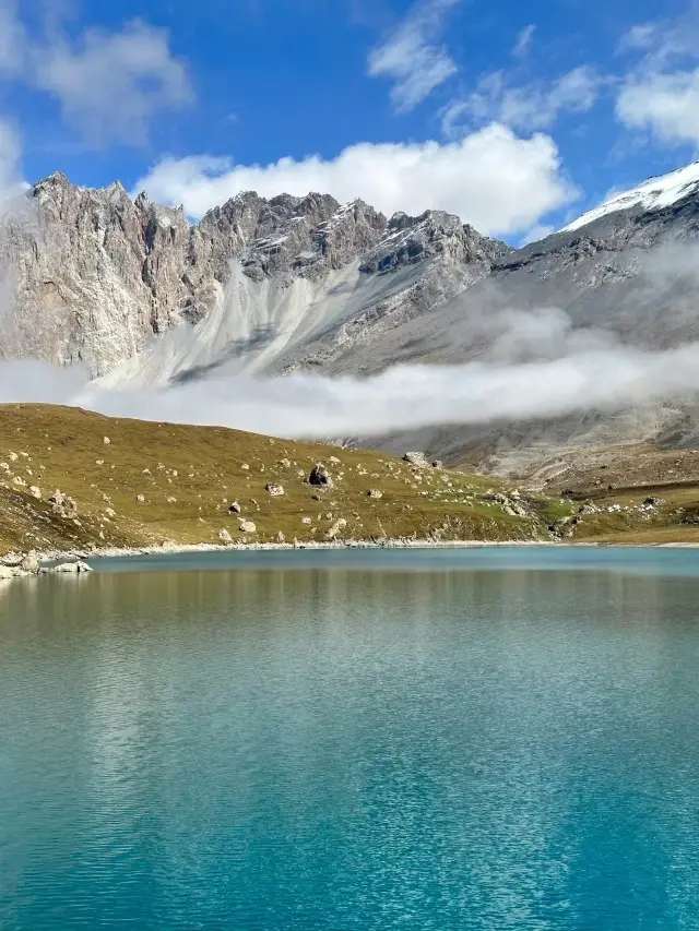
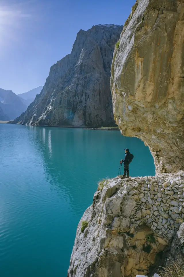 The Emerald on the Plateau--Heaven Lake on the Ancient Ussun TrailThe core attraction of the Ancient Ussun Trail is Heaven Lake, which possesses a breathtaking and astonishing beauty. With the sky so high and clouds so light, the lake's water is clear and blue, resembling an emerald set upon the plateau, hence its name. Heaven Lake is located at an altitude of 3100 meters, covering a total area of 2.81 square kilometers, shaped like a crescent moon. Under the blue sky and white clouds, the sunlight reflects off the profound lake surface, creating sparkling ripples that are bright, charming, and lively. The tranquil and clear waters of the lake, together with the high mountain meadows, form a beautiful landscape painting. Heaven Lake is nestled deep within the mountains, with waters so clear they resemble emerald blue. Under the blue sky and white clouds, the sunlight shines from behind the mountains, instantly warming one's heart, while the reflection of the snowy mountains quietly spreads across the beautiful lake surface. The integration of mountains and water is poetic and picturesque, offering an incomparably beautiful sight. Heaven Lake has a surface altitude of 3100 meters and covers a total area of 2.81 square kilometers. It is the most famous and core attraction within the Ancient Ussun Trail.EMMA MENDEZ
 I can guarantee that 99% of people who go to Xinjiang have never been to this placeHeaven Lake🌊, also known as Akkul High Mountain Lake, is located in the Tianshan Mountains⛰ in Xinjiang, a snow mountain glacier lake on the famous Wusun Ancient Road. It is also a landmark of the Wusun Ancient Road, shining like a pearl! 🚦Ways to reach Heaven Lake 1️⃣Helicopter round trip 2️⃣Hiking from Qiongkushitai Pastoral Village 3️⃣Hiking from Kuche 🚶♀️Recommended route 👉Qiongkushitai Pastoral Village-Qiongkushitai Kuye Village Camp-Qiongdaban-Kunosa Camp-Liusuo-Kekesu River Camp-Kekarapi Gorge-Heaven Lake-Erhuhu-Akebulakdaban-Bozikrigu River Ancient-Heiying Village-Kuche👈 ⏰Time required: 6-7 days 👀Kilometers: About 120KM, an average of about 20km per day, hiking for 7-8 hours ⚠️Tips ‼️All equipment should be prepared accurately to the gram, especially equipment and food ‼️Clothing: The inner clothing should be quick-drying and sweat-absorbing, and the jacket should be windproof, rainproof, and sunproof, etc. ‼️Hiking shoes: Very, very, very important, wear them for more than a week before departure, do not buy new shoes and walk directly ‼️Take away your own garbage, do not damage the environment along the way, disturb the habitat of wild animals ‼️From November to May, there is a lot of snow on the two Dabans, and the shoes need to be non-slip You will wade through the ice river dozens of times during the hike, and the water in the river is Tianshan snow water, which is very cold and bone-chilling, so you must have enough hiking experience and a strong body, otherwise it is not ❌ highly recommended to golyrona_4962
Nearby Attractions
lou lan gu dao | kang qi shi di · shi kong li · bing xue le yuan | kang qi shi di gong yuan | bai cheng xian tao le bao you le zhong xin | ka pu si lang he gong yuan | bai cheng zhong yang gong yuan | Baicheng Riverfront Park | Baicheng Cultural Center | Baicheng Library | Shengshi Huangchao Karaoke | tuo ke xun xiang wen hua ti yu zhong xin | bai cheng zhen wen hua ti yu huo dong zhong xin | bai cheng xian bu long xiang wen hua ti yu huo dong zhong xin | mi ji ke xiang wen ti huo dong zhong xin | sai li mu zhen wen hua huo dong zhong xin | Century Square | Baicheng Pingding Mountain Cultural Center | Kapusi Langhe | Hani Ka Canal | Tai'erwei Qiukehe | Dunda Wusitang | Mijike Canal | Pashita Qi'edan | Pashi Taqi Wusitang | Bugan Wusitang | Dunmaili Canal | Ana Kezi Wusitang | Jigelang Wusitang | Yingtashi Wusitang | Bulong Wusitang
Popular Types of Attractions in Baicheng
Nature | Grasslands | Forests | Mountains | Architecture & Landmarks | Featured Neighborhoods | Squares | Roads/Highways | Exhibition Centers | Exhibition Halls | Museums | Memorial Halls | Parks | City Parks | Botanical Gardens | Water Parks | Traditional/Cultural Experiences | Villages | Farms | Lifestyle | Campgrounds | Libraries | Resorts | Historic Sites | Historical Sites | Ancient Towns | Sports | Outdoor Sports | Fitness
Popular Restaurants in Baicheng
流浪漢鵝莊(拜城店) | 大眾火鍋 | 川府飯店 | 八樓豬蹄(拜城店) | 品味火鍋 | 百富烤霸(日新小區店) | 清香齋優質牛肉麵 | 愛的禮物(拜城店) | 冰島之戀 | 成都片片魚自助火鍋 | 四季香川味 | 70年代川菜館 | 小羊羔抓飯 | 小四川飯店 | 阿里朗抓飯 | 金剛爾沙饢坑烤肉拌麪王(拜城旗艦店) | 千椒百味牛大骨自助火鍋 | 優麥漢堡 | 火冒三丈火鍋 | 成記窩窩頭(拜城店) | 朝天門火鍋串串 | 寶地美食 | 六膳門缽缽雞 | 回民特色幹煸炒麵拌面飯莊 | 一品香刀削麵 | 飄香涼皮店 | 大龍坎火鍋 | 川味苑酒家 | 科晨餅店 | Hanxuan Milk Tea
Recommended Attractions at Popular Destinations
Bangkok attraction near me | Manila attraction near me | Tokyo attraction near me | Taipei attraction near me | Hong Kong attraction near me | Seoul attraction near me | Los Angeles attraction near me | Kuala Lumpur attraction near me | Shanghai attraction near me | New York attraction near me | Shenzhen attraction near me | Osaka attraction near me | London attraction near me | Singapore attraction near me | Guangzhou attraction near me | San Francisco attraction near me | Beijing attraction near me | Macau attraction near me | Bali attraction near me | Paris attraction near me | Jakarta attraction near me | Ho Chi Minh City attraction near me | Orlando attraction near me | Phuket attraction near me | Toronto attraction near me | Chicago attraction near me | Cebu attraction near me | Seattle attraction near me | Istanbul attraction near me | Fukuoka attraction near me
Popular Ranked Lists
Popular Family-friendly Attractions Near Taizhou | Popular Luxury Hotels Near Travemunde | Popular Luxury Hotels Near Arnhem | Top 10 Local Restaurants in Brisbane | Top 21 Local Restaurants in George Town | Top 19 Local Restaurants in Munich | Popular Family-friendly Attractions Near Yihuang | Top 15 Local Restaurants in Doha | Top 18 Local Restaurants in Bangkok | Top 11 Local Restaurants in Vientiane | Popular Family-friendly Attractions Near Huining | Popular Luxury Hotels Near Popayan | Top 18 Local Restaurants in Seattle | Top 22 Local Restaurants in Quanzhou | Top 16 Local Restaurants in Weihai | Top 20 Local Restaurants in Harbin | Popular Family-friendly Attractions Near Yiyang | Popular Family-friendly Attractions Near Hanyuan | Top 20 Local Restaurants in Cairo | Popular Family-friendly Attractions Near Huai'an | Top 9 Local Restaurants in Malé | Popular Premium Hotels Near Kalimpong | Top 21 Local Restaurants in Frankfurt | Popular Luxury Hotels Near Kumily | Popular Family-friendly Attractions Near Wan'an | Popular Family-friendly Attractions Near Fenghuang | Top 20 Local Restaurants in Chaozhou | Popular Luxury Hotels Near Bikaner | Popular Luxury Hotels Near Gori
Popular Trip Moments
The word 'stunning' is seldom used to describe a place | I rarely use the word 'stunning' to describe a place | Kizil Thousand Buddha Caves | Visit the Kizil Thousand Buddha Caves and experience the charm of 'China's second Dunhuang' | Step into the Wusun Ancient Trail and experience the grandeur of a historical epic lost to the world | Wusun Ancient Trail, a treasure secret realm exclusively for hiking enthusiasts | The Emerald on the Plateau--Heaven Lake on the Ancient Ussun Trail | If you don't go to the Wusun Ancient Trail now, you won't have the chance anymore! Because next year | Kizil Thousand Buddha Caves | I can guarantee that 99% of people who go to Xinjiang have never been to this place | Journey to the Paradise Lake on the Ancient Wusun Road: Step on the Silk Road and explore the paradise of ice and fire | The Ancient Wusun Road: Exploring the Secret Land in the Long River of History | Take a gamble, the ancient road of Wusun will definitely become popular this year.
More Things To Do in Baicheng
Tianshan Mysterious Grand Canyon + Kizil Thousand Buddha Caves + Kizil Red Stone Forest + Hongshan Stone Forest + Duku Highway Terminal Monument One-Day Tour [Secret Land in the Southern Foothills of Tianshan Mountain, Thousand-Year-Old Qiuci Ancient City] | 4-Day Kuqa and Kashgar from Urumqi Private Tour: Kuqa Grand Bazar, Tianshan Mysterious Grand Canyon, Kuche Temple, Kuche Royal Palace | 3-Day Urumqi Heavenly Lake and Turpan Private Tour: Tianchi Forest Park, International Bazaar, Bezeklik Thousand Buddha Caves, Karez System | 7-Day Silk Road Trip from Urumqi | 5-Day Urumqi to TurpanPrivate Tour: Karez System, Flaming Mountain Grand Canyon, Jiaohe Ancient City | 8-Day Urumqi,Turpan,Kashgar Private Tour include Heavenly Lake, Flaming Mountain | 12-Day South Xinjiang Private Tour included the Taklimakan Desert, Wensu Grand Canyon | Xinjiang Private Guided 4-Day Tour: Urumqi + Kuqa + Kashgar | Xinjiang + Gansu Private Guided 7-Day Tour: Urumqi + Dunhuang + Turpan + Jiayuguan | Xinjiang Private Guided 3-Day Tour: Urumqi + Turpan | 4 days tour from Urumqi to Kuqa and Kashgar | All-round day trip from Urumqi to Turpan | Flexible Turpan Day Tour from Urumqi with Lunch | Xinjiang Best Classic Silk Road Tour with Locals | Private 4-Day Tour to Kuqa and Kashgar from Urumqi | Kuqa Private Day Tour to Kizil Grottoes and Mystic Tianshan Grand Canyon | Private 2D Tour to Kizil Caves, Subash Ruin etc. from Urumqi by Round-way Flight | Private Day Tour to Kizil Caves and Tianshan Canyon from Urumqi by Air | All Inclusive Private Day Trip to Kizil Grottoes and Tianshan Gorge from Kuqa | Global eSIM J series in multiple regions | High-speed data for tourism and business Internet, unlimited data, optional days, QR code | Hong Kong eSIM local - Data plan by Gohub (QR Code) | [China Mainland] eSIM | SIM to China | 8GB 8days 4G high speed | [China, Hong Kong and Macau] CMCC SmarTone CTM | 5G daily data Traffic| 24-hour billing | 3-30 days | Uninterrupted network support hotspot sharing | eSIM | Mainland China + Hong Kong + Macau eSIM Data Plan QR Code | Global eSim for 140+ countries (sent via email) by Xplori | China eSIM Day Pass/data Package days selected without cards QR code | AIS SIM2Fly Global eSIM|15 days 6GB high-speed 4G/5G Unlimited Data | Mainland China eSIM |China Mobile 4G high-speed unlimited data eSIM | Global (66 Countries) eSIM Data Package (QR Code) | Global multi-region A series eSIM|High-speed data, travel and business Internet access, optional unlimited data, optional days, QR code
Payment Methods
Our Partners
Copyright © 2024 Trip.com Travel Singapore Pte. Ltd. All rights reserved
Site Operator: Trip.com Travel Singapore Pte. Ltd.
Site Operator: Trip.com Travel Singapore Pte. Ltd.
Wusun Ancient Road from Qiongkushitai Village in the north, to Heiyingshan Township in Baicheng County (also can be reversed), the whole journey is about 130km, on the way, it will overturn the snow-capped mountains, overturn the board, cross the virgin forest, the ice river, and the blue lake ....... Difficulty and scenery. Known as Xinjiang's "top landscape trail", it is called Xinjiang's three top hiking routes, along with Xiate Ancient Road and Wolf Tower.
Wusun Ancient Road, the north title of Zhungar Basin, the southern control of Tarim oasis, is the throat of Tianshan North and South, many nomadic peoples in history have to compete for this treasure. The Han Wu Emperor in BC made alliance with Wusun to fight the Huns; the Western Turks controlled Tianshan to rule the Tarim Basin in the Sui and Tang periods; The Tang Dynasty Xizheng Turku and the friendship with Turku Qishi, etc., were realized through Wusun Ancient Road.
Wusun Ancient Road refers to Wusun State to Guizi State through the north and south of Tianshan, hiking ancient roads are beautiful and very tired.
I don't know, I was shocked, it's really a paradise on earth, it's worth it.