https://nz.trip.com/moments/poi-lhasa-river-84888
5.0
4.7/5
266 review
 No. 5 of Night Attractions in Tibet
Hiking
Natural scenery
Night view
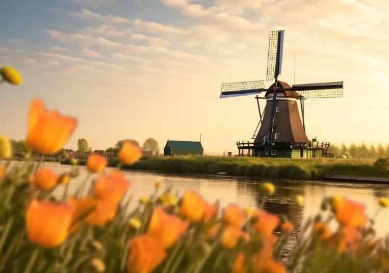
The Lhasa River, called Jiqu in Tibetan, originates from the southern foot of the Nyainqentanglha Mountain, flows southwest through Lhasa City, and then joins the Brahmaputra River in Qushui County. The lower river valley is relatively open and is the main farming area in Tibet. Lhasa River is the mother river of Lhasa City and has a great influence on the development of Lhasa. In 633 AD, after the Tubo monarch Songtsan Gampo unified the Tibetan tribes, he moved the capital to the Lhasa River Valley, and the Lhasa River Basin developed along with it, gradually becoming the central area of economy, culture, transportation and religion in the Tibetan Plateau. The Lhasa River Basin is about 551 kilometers long from east to west, with a drainage area of 32,471 square kilometers. It is the largest tributary of the Yarlung Zangbo River Basin. The climate here is mild, the terrain is flat, the soil is thick, the water source is abundant, and the soil quality is good. The basin is rich in plateau animals, plants and geothermal resources, making it one of the main grain producing areas in Tibet. You may not be able to spend so long with the Lhasa River like the locals, but in the evening, you can take a walk by the river near Xianzu Island and Tibet University, and enjoy the beauty of the sunset touching the horizon. What's even better is that there are many restaurants nearby, so you don't have to worry about food and clothing at all.
Lhasa River Address:
Chengguan District,Lhasa City
Lhasa River Recommended sightseeing time:
2-3 hours
Lhasa River Ticket Price
Free admission

Trending in Lhasa River
5-Day Lhasa-Shannan-Shigatse Tour: Detailed Itinerary and Travel Tips
Hey guys! Check out this 5-day in-depth tour of Lhasa, Shannan, and Shigatse, and explore the best of Tibet! This super useful guide is a must-read!
--------
🚗 Itinerary:
Day 1: Lhasa River > Gamba La Mountain > Yamdrok Lake > Karola Glacier > Manla Reservoir > Gyantse Dzong
Drive along the Lhasa River, cross Gamba La Mountain, and explore the beautiful scenery of Yamdrok Lake. Visit Karola Glacier and Manla Reservoir along the way, and finally arrive at the historic Gyantse Dzong.
Day 2: Gyatso La Pass > Mount Everest Scenic Area > Gawu La Mountain > Everest Base Camp > Rongbuk Monastery
Cross Gyatso La Pass and head straight to the Mount Everest Scenic Area. Cross Gawu La Mountain and arrive at Everest Base Camp to admire the majesty of the world's highest peak. Visit Rongbuk Monastery at Everest Base Camp to experience the religious culture of the plateau.
Day 3: Shishapangma > Peiku Tso > Dajiamang Tso > Dagejia Geyser
Admire the majesty of Shishapangma and explore the beauty of Peiku Tso and Dajiamang Tso. Finally, visit the magical Dagejia Geyser and marvel at the wonders of nature.
Day 4: Zhari Namco > Tangra Yumco
Visit Zhari Namco and admire the tranquil beauty of the plateau lake. Then head to Tangra Yumco and experience the charm of this mysterious body of water.
Day 5: Siling Co > Dazecuo > Namtso National Park > Namtso > Nagenla Mountain Pass > Nyenchen Tanglha Mountains
Cross Siling Co and Dazecuo to reach the magnificent Namtso National Park. Admire the beautiful scenery of Namtso, cross Nagenla Mountain Pass, and enjoy the majestic view of the Nyenchen Tanglha Mountains.
--------
Travel Tips:
- Local specialties: Dried beef and Tibetan handicrafts are affordable and make great souvenirs! 🎁
- December weather: Warm and comfortable during the day, cool at night. Remember to bring a down jacket and sunscreen! ☀️🧣
- Photo spots: Nanshan Park and Yaowang Mountain are great places to take panoramic photos of the Potala Palace! 📸
- Local customs: Respect Tibetan customs and avoid touching religious items to make your trip more enjoyable! 😊
--------
🎉 Lhasa's mystery, Shannan's magnificence, and Shigatse's sanctity. May your journey be a spiritual one!
MHECHO 25
4
Lhasa River
How can you come to Tibet without experiencing the night view of the Lhasa River🌙! Enjoy the plateau evening breeze while watching the reflection of the Potala Palace. Here is the most comprehensive night tour guide on the internet for you~
🌌 Night Tour Highlights:
- Stunning night view of the Potala Palace reflected in the Lhasa River
- Healing scene of prayer flags swaying under the moonlight along the riverbank
- The riverside boardwalk most loved by locals for walking
📍 Travel Guide:
1⃣ Best viewing spot: Xianzu Island Ecological Park section (Jiangsu East Road, Chengguan District), where the view is wide and you can see the complete reflection of the Potala Palace
2⃣ Recommended time: 9:00 PM - 11:00 PM (sunset is late in summer, before 7:00 PM is recommended in winter)
3⃣ Hidden spot: The waterside platform under Yingqin Bridge, less crowded and beautiful scenery
💡 Useful tips:
- The river breeze can be strong, remember to bring a jacket
- For photography, bring a tripod for better long exposure effects
- You can also check in at the nearby Guangming Port Qiong Sweet Tea House (Danjielin Road, Chengguan District)
🍵 Late-night snack recommendation:
After the tour, you can go to "Gangla Meiduo" (Beijing East Road, Chengguan District) for sweet tea. Their yak meat fried sauce noodles are also a late-night snack must-have!
Bell_Blythe_34
Lhasa to Nyingchi Travel Guide for Seniors
Three-Day Lhasa to Nyingchi Tour: The Perfect Choice for Silver-Haired Travelers! Starting from Lhasa, enjoy a leisurely stroll at Basum Lake, explore the lush Lulang Forest, and marvel at the grandeur of the Grand Canyon and Mount Namcha Barwa. The itinerary is thoughtfully designed to balance relaxation and sightseeing, featuring local delicacies like stone pot chicken, stargazing, and experiencing Nyingchi's folk culture with a Tibetan costume bonfire show. All-inclusive pricing ensures a hassle-free journey!
--------------------
Exciting Journey Awaits! Scroll Down 👇 for More Surprises!
--------------------
🚩 Itinerary Highlights:
Day 1: Stroll Along Lhasa River — Explore Kadeng Valley Scenic Area — View Mount Namcha Barwa — Traverse Yarlung Tsangpo Grand Canyon
Take a leisurely walk along the Lhasa River to soak in the fresh and tranquil highland atmosphere. Then, head to Kadeng Valley Scenic Area to discover the harmonious blend of nature and culture. In the evening, admire the majestic Mount Namcha Barwa from afar and delve into the awe-inspiring Yarlung Tsangpo Grand Canyon.
Day 2: Witness Mount Namcha Barwa Sunrise
Spend the entire day at Mount Namcha Barwa, waiting to capture the breathtaking view of the peak bathed in the first rays of sunlight—a true gift of nature.
Day 3: Basum Lake's Scenic Beauty — Relax on the Lake Island — Stroll Along Nyang River — Capture Memories at Nyang River Scenic Belt
Enjoy the serene beauty of Basum Lake and its surrounding mountains. Take a break on the lake island with a cup of tea. Then, wander along the Nyang River to experience the unique charm of highland rivers. Finally, create lasting memories at the Nyang River Scenic Belt with stunning photos. 📸
💫 Evening Activities:
Under the starry sky of Nyingchi, indulge in stargazing and listening to the wind—a truly enchanting experience. Participate in a Tibetan costume bonfire show to immerse yourself in Nyingchi's folk culture. Don't forget to savor the local specialty, stone pot chicken, for a delightful culinary treat! 🍲🌟
--------------------
Tips for Travelers:
🛫 Pre-book airport transfers for a smooth journey from Lhasa Airport to the city.
🍲 Don't miss the local delicacy, stone pot chicken—delicious and nourishing!
🙏 Respect local customs: remove hats and refrain from taking photos inside temples.
🌲 Nyingchi's natural beauty is best enjoyed with comfortable walking shoes.
💡 High-altitude reactions are common; prepare necessary medications and rest adequately.
--------------------
Don't hesitate! Click the card below to book your trip effortlessly and enjoy a smoother travel experience!
xzydgjlxs
3-Day Itinerary for Exploring Lhasa and Nyingchi
Looking for a unique Tibetan experience during your short holiday? Embark on a three-day journey from Lhasa to Nyingchi, savor authentic stone pot chicken, stargaze at night, listen to the whispers of the wind, and enjoy a Tibetan costume show and bonfire party. Immerse yourself in the distinctive culture and customs of Nyingchi!
🏞️ Itinerary:
Day 1: Stroll along the Lhasa River -> Visit the wonders of Kadeng Valley -> Marvel at the majestic Namcha Barwa Peak -> Explore the depths of the Yarlung Tsangpo Grand Canyon. This day's itinerary showcases the natural wonders of Lhasa and Nyingchi, from the tranquility of the riverside to the grandeur of the canyon, offering a feast for both the eyes and the soul.
Day 2: Immerse yourself in the lush greenery of Lulang Forest, breathe in the rhythm of nature, and enjoy a pure forest bath.
Day 3: Admire the scenic beauty of Basum Lake -> Experience the serenity of the island in the lake -> Take a leisurely walk along the banks of the Niyang River -> Enjoy the endless beauty of the Niyang River Scenic Belt. On the final day, you'll savor the aquatic charm of Nyingchi, harmonize with nature, and conclude this unforgettable journey by the picturesque riverside. 🌊✨
Additionally, don't miss the chance to experience Nyingchi's local customs—gather around the bonfire, stargaze, listen to the wind, relish the delicious stone pot chicken, and enjoy a Tibetan costume show to deeply appreciate the unique charm of Tibetan culture! 🔥🍲🎭
🎒 Travel Essentials: Lhasa-Nyingchi Packing List
👕 Clothing: Short-sleeve T-shirts, sunscreen shirts, light jackets; remember to bring a warm coat for the chilly nights.
👖 Bottoms: Durable jeans or quick-dry pants for outdoor activities.
👟 Footwear: Comfortable sneakers; if hiking, bring professional hiking shoes.
🎩 Headgear: Wide-brimmed hats and sunglasses for sun protection and style.
📲 Personal Items: Phone, charger, power bank to stay connected.
🪪 Important Documents: ID card, cash, and bank cards for a safe trip.
🌟 Lhasa-Nyingchi Journey: The most stunning scenery awaits you along the way. Don't forget to like and save this guide for more exciting adventures! 🌟
xzydgjlxs
1
5-Day Lhasa Tour: Stress-Free and Fun!
Don't miss the Lhasa adventure! Explore Tibet's sacred lakes and glaciers, experience the Roof of the World, and get up close with wildlife. Visit iconic spots like Yamdrok Lake, Karola Glacier, Mount Everest, Serling Tso, and Namtso—all in one trip! No shopping interruptions, all-inclusive pricing, and pure natural beauty await. Start your visual feast now!
--------
Travel Guide Unveiled: Don't miss the exciting details—scroll down to explore ↓
--------
🚩 Itinerary:
🌟 This trip features a compact and exciting schedule, showcasing Tibet's stunning landscapes! 🌟
Day 1: Lhasa River -> Yamdrok Lake -> Gamba La Mountain -> Karola Glacier -> Manla Reservoir
📝 On the first day, we follow the Lhasa River, visit the sacred Yamdrok Lake, cross Gamba La Mountain, marvel at the majestic Karola Glacier, and end the day at Manla Reservoir.
Day 2: 318 National Highway 5000km Monument -> Gyatso La Pass -> Everest Scenic Area -> Everest Town -> Mount Everest -> Mount Everest National Park
📝 On the second day, we head to the 5000km Monument on the 318 National Highway, traverse Gyatso La Pass, explore the Everest Scenic Area, experience the charm of Everest Town, admire the grandeur of Mount Everest, and visit Mount Everest National Park.
Day 3: Gawu La -> Lhotse -> Shishapangma -> Makalu -> Mount Everest -> Cho Oyu
📝 On the third day, we continue our journey from Gawu La, passing Lhotse, Shishapangma, and Makalu, revisit Mount Everest's magnificence, and conclude at Cho Oyu, experiencing the majestic mountain ranges.
Day 4: Shigatse -> Namling -> Jiega Rishen Mountain -> Cedonglin Tso -> Serling Tso
📝 On the fourth day, we drive from Shigatse to Namling, pass the mysterious Jiega Rishen Mountain, visit the tranquil Cedonglin Tso, and finally arrive at Serling Tso—Tibet's Devil Lake—to experience its unique charm. Overnight stay in a standard room at a basic hotel in Bango.
📢 Note: Bango's altitude is approximately 4670m, so prepare for high-altitude conditions.
Day 5: Bamu Tso -> Namtso -> Nagen La Pass -> Nyenchen Tanglha Viewing Platform
📝 On the final day, we visit the lakes Bamu Tso and Namtso, cross Nagen La Pass, and enjoy panoramic views of the plateau from the Nyenchen Tanglha Viewing Platform, concluding the trip on a high note.
--------
Recommended Attractions:
Yamdrok Lake ⭐⭐⭐⭐
Address: Gonggar County, Shannan City, Tibet Autonomous Region, Provincial Road 307
Opening Hours: 08:00-18:00
Suggested Duration: 1-3 hours
Known as the paradise for water birds in southern Tibet, the lake resembles a mirror, dotted with islands—truly breathtaking.
Karola Glacier ⭐⭐⭐⭐
Address: Border of Jiangzi County, Shigatse City, Tibet Autonomous Region
Opening Hours: 07:00-18:00
Suggested Duration: 1-2 hours
A former movie filming location, the glacier's majestic beauty is a sight to behold.
Everest Scenic Area ⭐⭐⭐⭐
Address: Intersection of National Highway 318 and Everest Road, Dingri County, Shigatse City
Opening Hours: Open all day
Suggested Duration: 1 day
From the viewing platform, enjoy the sunrise and panoramic views of surrounding mountains—truly awe-inspiring.
Mount Everest ⭐⭐⭐⭐
Address: Border of Dingri County, Shigatse City, Tibet Autonomous Region, and Nepal
Opening Hours: Open all day
Suggested Duration: 1 day
The pyramid-like structure of Mount Everest is imposing and majestic, with its snow-capped peak adding to its grandeur.
Namtso ⭐⭐⭐⭐
Address: Near Zhaxi Temple, Damxung County, Lhasa City, Tibet Autonomous Region
Opening Hours: May 1 - Dec 31, 08:00-20:00
Suggested Duration: 1-2 days
As one of Tibet's sacred lakes, Namtso's tranquility and the reflection of snow-capped mountains in its waters are mesmerizing.
--------
Travel Essentials: 🎒 Here's your packing list for a trip to Lhasa and beyond!
👕 Clothing: Bring a lightweight down jacket and sun-protective clothing—May in Lhasa has significant temperature differences between day and night, with strong sunlight during the day. Don't forget a hat and sunglasses for sun protection and style!
👟 Footwear: Comfortable sneakers are a must. If you're hiking or climbing, they'll help you go the extra mile.
📲 Electronics: Phone, charger, power bank—essential for photos, navigation, and more. Consider bringing a camera to capture beautiful moments.
💳 Documents: ID card, student ID, driver's license (if self-driving)—check them before departure for a smooth journey.
💊 Other Essentials: Sunscreen, lip balm—high-altitude climates are dry, and these will keep you hydrated. Also, pack some common medications for emergencies.
--------
Click the card below to discover more exciting travel essentials!
深耕西藏旅遊的鵬翔

Recommended themes

2025 Recommended Guides in Lhasa River (Updated October)
93 posts
2025 Recommended Comprehensive guides in Lhasa River (Updated October)
88 posts

2025 Recommended Attraction in Lhasa River (Updated October)
88 posts
Detailed guide for a 3-day trip from Lhasa to Nyingchi, avoid minefields!
From Lhasa to Nyingchi, three days of relaxing and worry-free travel! The aroma of stone pot chicken fills the air, and the golden mountain of Mount Nanga Bawa under the sunlight is magnificent and stunning. Wear Tibetan costumes to take beautiful photos, join the bonfire party and have fun, deeply experience the customs of Nyingchi, and feel relaxed and comfortable!
--
There are endless exciting contents. Scroll down to unlock more travel tips↓
--
🌄Itinerary:
Day 1: Stroll along the Lhasa River - Explore the Kading Valley Scenic Area - Overlook the golden mountain of Mount Nanga Bawa in the sun - Cross the Yarlung Zangbo Grand Canyon
Feel the tranquility of the plateau by the Lhasa River, and then head to the Kadinggou Scenic Area to explore the natural wonders. In the evening, look out over Mount Namjagbarwa and enjoy the spectacular sight of the golden mountain in the sun. Finally, go deep into the Yarlung Zangbo Grand Canyon to experience its ruggedness and magnificence.
Day 2: Tibetan costume show in Suosong Village - Climbing Sejila Mountain - Encountering Mount Namjagbarwa again - Walking in Lulang Forest
Put on Tibetan costumes in Suosong Village, participate in the local Tibetan costume show, and feel the charm of Tibetan culture. Afterwards, we crossed the Sejila Mountain and once again looked out at the majestic Mount Namjagbarwa. Arrive at Lulang Forest Sea, stroll along the forest trails, and enjoy the freshness and tranquility of nature. In the evening, you can also attend a bonfire party and experience the folk customs of Nyingchi.
Day 3: Rafting in Basongcuo - Resting on the lake island - Rafting on the Niyang River - Enjoying the Niyang River Scenic Belt
Go boating on Basongcuo Lake and feel the tranquility and beauty of the plateau lake. Then head to the island in the middle of the lake to enjoy a moment of leisure. In the afternoon, drift along the Niyang River and enjoy the scenery along the way. Finally, take a stroll in the Niyang River Scenic Area to appreciate the unique charm of the plateau river. You can also try the delicious stone pot chicken to end your pleasant journey.
--
Attractions suggestions:
Mount Nanga Bawa ⭐⭐⭐⭐
- Address: Xizanglin, Milin County, Nyingchi City, Tibet Autonomous Region
- Opening hours: Open all day
- Play time: 2-4 hours
- The 15th highest peak in the world, the mountain is shrouded in clouds and mist all year round, like a fairyland.
Yarlung Zangbo Grand Canyon ⭐⭐⭐⭐
- Address: Pai Town, Milin City, Nyingchi City, Tibet Autonomous Region
- Opening hours: 08:30-20:00; 09:30-18:00
- Duration: 1-2 days
- The Grand Canyon that shocked the world, with its magnificent and diverse scenery, is a paradise for explorers.
Sosong Village ⭐⭐⭐⭐
- Address: Yarlung Zangbo Grand Canyon, Milin City, Nyingchi City, Tibet Autonomous Region
- Opening hours: Open all day
- Play time: 1-3 hours
- The beautiful place with peach blossoms in full bloom in the Tibetan area and the quiet village beside the river and snow are picturesque.
Basongcuo ⭐⭐⭐⭐
- Address: Cogao Township, Gongbujiangda County, Nyingchi City, Tibet Autonomous Region
- Opening hours: May 1st - October 31st 09:00-18:30
- Playing time: 2-3 hours
- A sacred lake of the Red Sect of Tibetan Buddhism, it has a high religious status and its beautiful scenery is refreshing.
--
**Tips**:
* Photo spot: Potala Palace Square in Lhasa, the night view is super beautiful, don’t miss it! 📸
* Customs and customs: In Nyingchi, when you meet Tibetan compatriots, smile and say hello~😊
* Airport transportation: From Lhasa Airport to the city, it is recommended to take the airport bus, which is convenient and economical. 🚌
* Food suggestion: Be sure to try Nyingchi’s specialty – stone pot chicken! 🍲
--
↓Click on the card below to easily book a group tour and travel more worry-free
深耕西藏旅遊的鵬翔
Lhasa-Shannan-Shigatse 3-Day Tour: Explore the Mystical Tibet
Spring is the perfect time to uncover the secrets of Tibet with this 3-day tour covering Lhasa, Shannan, and Shigatse! Follow this guide for a hassle-free journey, gaze at the dazzling night sky, and quickly reach the base of Mount Everest to marvel at the breathtaking spring scenery of the snowy plateau. Don't miss out!
--------
Carefully prepared guide, 👇 scroll down to explore more!
--------
🚩 Itinerary:
Day 1: Stroll along the Lhasa River — Immerse in the blue of Yamdrok Lake — Cross the Gamba La Mountain — Discover the Karola Glacier — Capture memories at Manla Reservoir
Experience the tranquility of the plateau by the Lhasa River, then head to the stunning Yamdrok Lake, whose blue waters are mesmerizing. Next, cross the Gamba La Mountain, enjoying the endless scenery along the way. In the afternoon, visit the ancient Karola Glacier to witness remnants of the Ice Age. Finally, arrive at Manla Reservoir, a picturesque spot perfect for photography enthusiasts.
Day 2: Snap a photo at the 5000km milestone on National Highway 318 — Admire the grandeur of Mount Everest — Stroll through Everest Town — Explore the Everest Scenic Area — Experience Everest National Park — Stay overnight in Everest Town and gaze at the starry galaxy
This day begins with a memorable stop at the 5000km milestone on National Highway 318. Then, head to the Everest Base Camp to admire the towering Mount Everest and its majestic beauty. Take a leisurely walk through Everest Town to experience the unique architecture and culture of the plateau. In the afternoon, delve into the Everest Scenic Area to uncover the mysteries of the snow-capped mountains. At Everest National Park, marvel at the vast and magnificent natural landscapes. At night, stay in Everest Town, where the starry galaxy feels almost within reach.
Day 3: Bid farewell to Everest Town — Cross the Gyawu La Mountain Pass — Overlook the Jia Cuo La Mountain Pass — Look back at the beauty of Mount Everest — Gaze at Shishapangma and Lhotse Peaks
Leaving Everest Town, cross the Gyawu La Mountain Pass to experience the desolate and expansive plateau. Then, arrive at Jia Cuo La Mountain Pass to overlook the spectacular view of the endless mountain ranges. On the way back, take one last look at Mount Everest, leaving with a deep sense of longing. Finally, gaze at Shishapangma and Lhotse Peaks, two snow-capped mountains standing side by side, creating a beautiful scene to conclude the journey. 🌟
--------
Recommended Attractions:
Yamdrok Lake ⭐⭐⭐⭐
Address: 307 Provincial Road, Gonggar County, Shannan City, Tibet Autonomous Region
Opening Hours: 08:00-18:00
Suggested Duration: 1-3 hours
The lake is like a mirror, with scattered islands. It's a paradise for water birds in southern Tibet.
Gamba La Mountain ⭐⭐⭐
Address: Border of Langkazi County and Gonggar County, Shannan City
Opening Hours: Open all day
Suggested Duration: 1 hour
The mountain top offers a great vantage point to overlook the beauty of Yamdrok Lake. Don't miss it!
Karola Glacier ⭐⭐⭐⭐
Address: Border of Jiangzi County, Shigatse City, Tibet Autonomous Region
Opening Hours: 07:00-18:00
Suggested Duration: 1-2 hours
Once a filming location, the magnificent scenery here will surely amaze you.
Mount Everest ⭐⭐⭐⭐
Address: Border of Dingri County, Shigatse City, Tibet Autonomous Region, and Nepal
Opening Hours: Open all day
Suggested Duration: 1 day
The pyramid-shaped Mount Everest is majestic and awe-inspiring, with its snow-covered peak being particularly spectacular.
Everest Scenic Area ⭐⭐⭐⭐
Address: Intersection of National Highway 318 and Everest Road, Dingri County, Shigatse City
Opening Hours: Open all day
Suggested Duration: 1 day
Climb the viewing platform to enjoy the sunrise and take in the panoramic view of the surrounding mountains.
--------
🎒 Packing List:
👕 Clothing: Long-sleeved shirts, sun-protective jackets, jeans or long pants, comfortable sneakers.
🎩 Sun Protection: Wide-brimmed hat, sunglasses, high-SPF sunscreen.
💧 Moisturizing Items: Lip balm, hand cream, facial moisturizing spray.
💊 Essential Medications: Rhodiola, cold medicine, painkillers, band-aids.
📷 Photography Gear: Camera, spare batteries, charger, tripod.
🪪 Important Documents: ID card, cash, bank card, some loose change.
🍫 Miscellaneous Items: Portable oxygen bottle, chocolate or energy bars, water bottle.
--------
Book with one click for a hassle-free trip. Click the product card below to make your travel easier!
深耕西藏旅遊的鵬翔
Lhasa to Nyingchi: A Detailed Travel Guide for Old Friends
Old Friends! Here's a three-day travel guide from Lhasa to Nyingchi! Experience the tranquility of Basum Lake, the grandeur of Lulang Forest, and the breathtaking sight of Mount Namcha Barwa's golden sunrise. Don't forget to savor the authentic stone pot chicken and enjoy Nyingchi's unique Tibetan costume show and bonfire party!
--
Recommended Itinerary: 🌟🌟
Day 1: Stroll along Lhasa River – Explore Kadeng Valley Scenic Area – Watch the golden sunrise at Mount Namcha Barwa – Traverse the Yarlung Tsangpo Grand Canyon
In the morning, take a leisurely walk along the Lhasa River and breathe in the fresh highland air. Then, head to Kadeng Valley Scenic Area to discover the beauty of nature and culture. In the evening, visit Mount Namcha Barwa to witness the magnificent golden sunrise, marking a perfect end to the first day.
Day 2: Deep Dive into Suosong Village – Cross Sejila Mountain – Revisit Mount Namcha Barwa – Explore Lulang Forest
At Suosong Village, immerse yourself in Nyingchi's local customs, enjoy the Tibetan costume show, and have fun at the bonfire party. Then, cross the majestic Sejila Mountain and revisit Mount Namcha Barwa to admire its charm from a different perspective. Finally, delve into the mysteries and serenity of Lulang Forest, a pristine woodland.
Day 3: Basum Lake Adventure – Stroll on the Lake Island – Scenic Views Along the Nyang River – Capture Memories at Nyang River Scenic Belt
On the third day, visit the picturesque Basum Lake and enjoy the tranquility and beauty of this highland lake. Take a leisurely walk on the lake island, soaking in the stunning lake and mountain views. Then, follow the Nyang River to admire its enchanting scenery and leave beautiful memories at the Nyang River Scenic Belt. This journey not only showcases the grandeur of nature but also offers a deep dive into Nyingchi's local culture. 🌄🌲📸
--
Must-Visit Attractions:
🏔️ Mount Namcha Barwa: The scenery here is amazing! Multiple viewing points are accessible by sightseeing buses, making it easy for senior travelers to enjoy.
🌊 Yarlung Tsangpo Grand Canyon: Stunning views! From Mount Namcha Barwa to the Yarlung Tsangpo River, Nyang River, and ancient villages, this is a perfect spot for a relaxed exploration.
🛕 Basum Lake: A harmonious blend of gentle landscapes and ancient temples, along with unique sculptures waiting to be admired. Sightseeing buses make it easy for senior travelers to enjoy the serene natural beauty and profound religious culture.
--
🎒 Travel Essentials:
👕 Clothing: Bring a lightweight down jacket and fleece, as Lhasa nights in May can be chilly.
👟 Footwear: Make sure to pack non-slip, warm hiking shoes for easier exploration of attractions.
🕶️ Sun Protection: Sunglasses and sunscreen are a must; highland UV rays are no joke.
💊 Medication: Prepare anti-altitude sickness remedies like Rhodiola and Salvia, along with regular medications such as cold medicine.
📷 Photography Gear: DSLR camera, spare batteries, and memory cards to capture every stunning view.
💳 Personal Items: Carry some cash, bank cards, and don't forget your ID.
🎧 Other Essentials: For long bus rides, headphones and power banks are great companions.
--
Lhasa to Nyingchi trip, accompanied by old friends, makes the scenery even more beautiful. May this journey become an unforgettable memory for you all! 🌸
深耕西藏旅遊的鵬翔
Lhasa-Nyingchi Three-Day Tour Guide
Three-day tour from Lhasa to Nyingchi, awesome guide here! Taste the fragrant stone pot chicken, witness the stunning view of Mount Nanga Bawa under the golden sunlight, and enjoy the Tibetan bonfire party. You can see the snow-capped mountains and holy lakes, explore the canyon forests, and experience the unique folk customs of Nyingchi. All-inclusive price, no shopping, just pure fun, collect it now!
Must-see attractions:
Mount Nanga Bawa ⭐⭐⭐⭐
- Address: Xizanglin, Milin County, Nyingchi City, Tibet Autonomous Region
- Opening hours: Open all day
- Play time: 2-4 hours
- The world's 15th highest peak is often shrouded in clouds and mist, like a fairyland.
Yarlung Zangbo Grand Canyon ⭐⭐⭐⭐
- Address: Pai Town, Milin City, Nyingchi City, Tibet Autonomous Region
- Opening hours: 08:30-20:00 or 09:30-18:00
- Duration: 1-2 days
- Walk into the world-famous Grand Canyon and enjoy the diverse scenery inside the canyon.
Sosong Village ⭐⭐⭐⭐
- Address: Yarlung Zangbo Grand Canyon, Milin City, Nyingchi City, Tibet Autonomous Region
- Opening hours: Open all day
- Play time: 1-3 hours
- The beautiful scenery of peach blossoms in full bloom in Tibet is intoxicating, and the villages beside the river and snow are quiet and peaceful.
Basongcuo ⭐⭐⭐⭐
- Address: Cogao Township, Gongbujiangda County, Nyingchi City, Tibet Autonomous Region
- Opening hours: May 1st - October 31st 09:00-18:30
- Playing time: 2-3 hours
- A sacred lake of the Red Sect of Tibetan Buddhism, it has a high religious status, clear water and a quiet environment.
Travel tips:
1️⃣ Don’t miss Lhasa’s specialty food - stone pot chicken. The rich soup and tender chicken are your delicious supplement on the plateau! 🍲💪
2️⃣ After arriving at Lhasa Airport, you can take the airport bus or arrange a taxi in advance to go to the city conveniently. 🚖🛫
3️⃣ In the old city of Lhasa, the Potala Palace and the Jokhang Temple are must-see photo spots. Don’t forget to take beautiful photos! 📸✨
4️⃣ The peach blossoms in Nyingchi are breathtakingly beautiful. Spring is the best season for viewing them, so don’t miss it! 🌸🌼
5️⃣ Altitude sickness is a common phenomenon. Prepare common medicines, get enough rest, and slowly adapt to the high altitude environment. 💊🌄
6️⃣ Remember to stay hydrated. In plateau areas, moisturizing and sun protection are also very important. 💧🧴
↓Click on the card below to easily book a group tour and start your travel journey
深耕西藏旅遊的鵬翔
Famous attractions in Lhasa, Tibet, China: Lhasa River, suitable for checking in and taking photos📸
#Mainland Travel
Lhasa in Tibet, China is a world-famous tourist resort city. Every day, thousands of tourists come here for sightseeing and vacation. There are many scenic spots in Lhasa. This time I will introduce a very famous scenic spot in Lhasa: Lhasa River.
The Lhasa River, bathed in the brilliant sunshine of the "City of Sunshine", is the mother river of Lhasa and the river of life of Tibet. It flows quietly, nourishing the land on both sides with its clear water and nurturing life here.
The water of the Lhasa River is as clear and bright as its eyes. You can see the sand and rocks at the bottom of the river and the fish playing in the river. A breeze blew by, and ripples appeared on the surface of the river, like millions of silver snakes dancing. On both sides of the Lhasa River, there is lush vegetation, just like its beautiful hair, swaying gently in the wind. You can see willows, poplars, pines, cypresses and other trees, as well as various flowers and plants growing along the river bank, adding a touch of green to the Lhasa River.
The banks of the Lhasa River are a beautiful and refreshing natural scenery. You can see snow-capped mountains in the distance, cattle and sheep on the grassland, and white clouds floating in the blue sky. Everything here is so peaceful and harmonious, making people feel the charm of nature.
When you come to Lhasa River, don't miss the Lhasa River Night Market. Here you can find the most authentic Tibetan snacks, allowing you to enjoy the local customs while eating. You can taste butter tea, highland barley wine, tsampa and other special foods to satisfy your taste buds here.
The Potala Palace Square is a great place to take photos. You can stand in the square and take beautiful photos with the Potala Palace as the background. The magnificent view of the Potala Palace and the snow-capped mountains and grasslands in the distance are in full view, making your photos more meaningful.
Trex club
【Lhasa Spring Outing】Unlock the Lhasa Flower Viewing Guide When Peach Blossoms Bloom!
As the spring breeze sweeps through the holy city of Lhasa, everything comes back to life, and the peach blossoms bloom as scheduled. In this vibrant season, let's step into Lhasa together, explore the peach blossom gardens hidden in the streets and alleys, and embark on a visual and spiritual feast.
[Guide 1: Best Time to View Flowers]
The peach blossom season in Lhasa is usually from mid-March to the end of April. This period is when the peach blossoms are in full bloom and is also the golden time for photography enthusiasts and tourists.
[Guide 2: Recommended Flower Viewing Locations]
Around the Potala Palace: The peach blossoms outside the palace walls form a sharp contrast with the magnificent palace, making it an excellent place for taking photos.
Norbulingka: As the summer palace of the Dalai Lamas, the garden has a wide variety of peach blossoms. When the flowers are in bloom, it is picturesque.
Lhasa River: Stroll along the Lhasa River, and the peach blossoms on both sides complement the river, creating a unique flavor.
[Guide 3: Shooting Tips]
Use foreground: Choose a peach blossom that is in full bloom as the foreground, and use the distant Potala Palace or Lhasa city as the background to increase the layering of the photo.
Light selection: The light in the morning and evening is soft, which is the best time to photograph peach blossoms. It can better show the details and colors of the peach blossoms.
[Guide 4: Outfit Suggestions]
Color matching: Choose colors that complement the peach blossoms, such as white and light blue, to easily blend into the sea of flowers and become a person in the painting.
Comfort first: You may need to walk a lot during flower viewing, so it is recommended to wear light and comfortable shoes.
[Guide 5: Precautions]
Sun protection and moisturizing: Lhasa has strong ultraviolet rays. Remember to apply sunscreen and bring moisturizing products when viewing flowers.
Respect local culture: In the process of flower viewing, please respect local customs and do not pick flowers at will.
Lhasa's peach blossoms are not only the messengers of spring, but also a beautiful landscape on the plateau. This spring, let us make beautiful wishes under the peach trees in Lhasa and feel the vigor and beauty of life.
The peach blossoms in Lhasa are in full bloom, and this flower viewing guide is waiting for you to unlock. Bring a good mood and let us meet in the holy city of Lhasa in the season when the peach blossoms are in full bloom!
CosmicWaves6666
Lhasa-Nyingchi 3-Day In-Depth Tour: A Complete Guide to Must-Visit Attractions
Hey, guys! This is the most enjoyable way to spend three days traveling from Lhasa to Nyingchi! Savor the delicious Stone Pot Chicken, witness the awe-inspiring golden sunrise over Mount Namjagbarwa, and explore the magnificent Lulang Forest. Save this guide and start your highland adventure!
/
🌄Itinerary:
Day 1: Stroll along Lhasa River -> Drive along Lhasa-Nyingchi Expressway -> Enjoy flowers in Gala Peach Blossom Village -> Watch the golden sunrise over Mount Namjagbarwa 🏔️
Experience the tranquility of the plateau along the Lhasa River, then drive along the Lhasa-Nyingchi Expressway to Gala Peach Blossom Village, where the blooming peach blossoms are intoxicating. In the evening, head to Mount Namjagbarwa and wait for the stunning golden sunrise.
Day 2: Explore the Yarlung Zangbo Grand Canyon -> Enjoy a panoramic view from Mt. Sejila -> Take a deep breath in Lulang Forest 🌲
Explore the wonders of nature in the Yarlung Zangbo Grand Canyon. Then, climb Mt. Sejila for a panoramic view of the rolling mountains. Finally, come to Lulang Forest, feel the freshness and tranquility of the forest, and purify your soul.
Day 3: Relax on the shore of Basum Lake -> Stroll around the island in the center of the lake -> Take photos on the bank of Niyang River -> Enjoy a panoramic view of the city from Chakpori Hill Viewing Platform 📸
Enjoy a leisurely time on the shore of Basum Lake, stroll to the island in the center of the lake, and feel the beauty of the sky and water. Then go to the Niyang River and take unforgettable photos. Finally, climb the Chakpori Hill Viewing Platform and enjoy a panoramic view of the city.
/
**Attraction recommendations**:
⭐⭐⭐⭐ **Basum Lake**
Address: Cuogao Township, Gongbo'gyamda County, Nyingchi City, Tibet Autonomous Region
Opening hours: November 1, 2024 - April 30, 2025, 09:00-18:30
Recommended duration: 2-3 hours
As a famous sacred lake of the Red Sect of Tibetan Buddhism, it not only has beautiful scenery, but also a profound religious and cultural heritage.
⭐⭐⭐⭐ **Yarlung Zangbo Grand Canyon**
Address: Pai Town, Mainling County, Nyingchi City, Tibet Autonomous Region
Opening hours: March 1 - October 31, 09:30-22:00
Recommended duration: 1-2 days
Known as the world's grand canyon, it has spectacular canyon scenery and diverse natural landscapes.
⭐⭐⭐⭐ **Mount Namjagbarwa**
Address: Mainling County, Nyingchi City, Tibet Autonomous Region
Opening hours: Open all day
Recommended duration: 2-4 hours
As the 15th highest peak in the world, Mount Namjagbarwa is famous for its cloud-shrouded mountain scenery and is a paradise for mountaineering enthusiasts.
⭐⭐⭐ **Lulang Forest**
Address: Lulang Town, Bayi District, Nyingchi City, 318 National Road, Tibet Autonomous Region
Opening hours: 06:00-18:00
Recommended duration: 2-4 hours
Along the 318 National Road, you can admire this continuous green forest and feel the tranquility and magnificence of nature.
⭐⭐⭐ **Chakpori Hill Viewing Platform**
Address: No. 2 Luobulinka Road, Chengguan District, Lhasa
Opening hours: 07:00-19:00
Recommended duration: 15-30 minutes
This is a great location to view the Potala Palace, especially at sunrise. The picturesque scenery is definitely not to be missed.
/
Some tips:
📸 Photo Spots: Don't miss the beautiful scenery of Lhasa Potala Palace Square and Nyingchi Mount Namjagbarwa!
🍲 Food Recommendations: Be sure to try the Nyingchi Stone Pot Chicken, with its delicious soup and tender meat. Foodies, don't miss it!
🎁 Souvenir Prices: When buying Tibetan handicrafts, compare several stores and bargain reasonably to avoid impulsive purchases.
/
✨️The mystery of Lhasa and the beauty of Nyingchi are all the scenery along the way! Remember to like and save this guide, and come back to me for your next trip! ✨️
ASHTON SIMS
Citywalk Discovery: Breathtaking Walking Tours in Nyingchi and Beyond
|Breathtaking Walking Tours in Nyingchi and Beyond. During the Qingming Festival, it's the perfect time to admire the peach blossoms in Nyingchi! In addition to the colorful sea of flowers, there are also Tibetan costume Trip Moments in Lhasa to record your beauty, land-pulling videos to challenge the limits of your courage, drone aerial photography to capture the magnificent scenery from a high-altitude perspective, and a leisurely afternoon tea time by the holy lake. Quickly collect this 6-day Nyingchi travel guide and start your wonderful journey!
/
🏃Itinerary:
Day 1: Lhasa-Nyingchi Expressway -> Gala Peach Blossom Village -> Yarlung Zangbo Grand Canyon -> Mount Namjagbarwa
Drive along the Lhasa-Nyingchi Expressway and enjoy the magnificent natural scenery. Then, visit Gala Peach Blossom Village and feel the beauty of the peach blossoms in full bloom. In the afternoon, go deep into the Yarlung Zangbo Grand Canyon and appreciate the wonders of nature. Finally, enjoy a distant view of the majestic Mount Namjagbarwa and end a fulfilling day.
Day 2: Gongdelin Grassland -> Dagu Gorge Scenic Area -> Monkey-Watching Platform
Stroll on the Gongdelin Grassland and enjoy the peace and harmony of nature. Then, go to Dagu Gorge Scenic Area and explore the depth and beauty of the canyon. Finally, get up close and personal with the cute monkeys at the Monkey-Watching Platform and feel the harmonious coexistence with nature.
Day 3: Yamdrok Lake -> Karola Glacier -> Manla Reservoir
First, come to Yamdrok Lake and enjoy the beautiful scenery of the lake and mountains. Then, visit Karola Glacier and feel the magnificence and mystery of the glacier. Finally, go to Manla Reservoir and appreciate the tranquility and magnificence of the plateau reservoir.
Day 4: Gya-tso La Mountain Pass -> Mount Everest Base Camp -> Mount Everest
Cross the Gya-tso La Mountain Pass and feel the vastness and expanse of the plateau. Then, arrive at Mount Everest Base Camp and admire the majesty and mystery of Mount Everest up close. Here, you can take photos to your heart's content and record this unforgettable moment.
Day 5: Gawu La Mountain
Conquer Gawu La Mountain and overlook the magnificent scenery of the continuous mountains. Here, you can take Tibetan costume Trip Moments or land-pulling videos to leave unique memories. At the same time, you will also have the opportunity to enjoy the magnificent scenery taken by fixed-point drone aerial photography.
Day 6: Nyainqêntanglha Mountain Viewing Platform -> Nagen La Mountain Pass -> Lake Namtso -> Lhasa River
After enjoying the beautiful scenery from the Nyainqêntanglha Mountain Viewing Platform, go to Nagen La Mountain Pass to feel the vastness of the plateau. Then, come to the shore of Lake Namtso to enjoy a leisurely afternoon tea time by the holy lake. Finally, return to Lhasa along the Lhasa River and end your pleasant journey. 🏞️
/
Pre-trip essentials: Here is the travel checklist for Nyingchi and other places 🧳!
👕 Clothing: Down jackets and thermal underwear must be brought, and a light jacket is enough for daytime use. Also, don't forget breathable sneakers!
🎒 Accessories: A large-capacity backpack to hold your water bottle, rain gear, and sunscreen. Also, a power bank is also a must-have for going out!
📜 Documents: Be sure to bring your ID card and passport, which are essential for buying tickets and accommodation. Don't forget your student ID and driver's license if you have them!
💊 Health: Rhodiola and Gaoyuan'an are very effective against altitude sickness. Also, prepare some common medicines such as cold medicine and pain relievers!
📷 Equipment: Use your mobile phone and camera to record beautiful moments. Spare batteries or chargers are also very important. Don't miss any beautiful scenery!
💰 Others: Prepare some cash and bank cards. Although electronic payment is very convenient, cash is still king in some places!
/
Come and take a Nyingchi group tour that you can just take off on. Beautiful scenery is waiting for you to explore. Don't hesitate, start now!
hollythunder
Lhasa-Nagqu City Walk: Explore the Best in Two Days
Lhasa to Nagqu, a beautiful journey! Camp by the lake, sleep under the stars, greet the dawn and dusk, and admire the brilliant Milky Way. A two-day itinerary, a unique experience, come and explore!
--------------------
🚗Itinerary:
DAY 1: Depart from Lhasa River - View the snow-capped mountains from the Nyainqentanglha Mountain viewing platform - Cross the Nagqu Pass - Stay overnight at the Namtso Holy Elephant Gate Lakeside Camp🌌
Experience the plateau morning by the Lhasa River, then head to the Nyainqentanglha Mountain viewing platform to witness the magnificence of the snow-capped mountains. In the afternoon, we will cross the Nagqu Pass, enjoying the boundless scenery along the way. At night, stay at the Namtso Holy Elephant Gate Lakeside Camp, sleep under the stars, and enjoy the tranquility and mystery of the plateau.
DAY 2: Gallop across the Northern Tibet Grassland - Revisit Nagqu Pass - Look back at the Nyainqentanglha Mountain viewing platform - Return to Lhasa🏞️
Wake up in the vastness of the Northern Tibet Grassland and experience the breathtaking plateau sunrise. Afterward, we will pass through Nagqu Pass again, reliving yesterday's splendor. On the way, don't forget to look back at the Nyainqentanglha Mountain viewing platform, where the snow-capped mountains still stand tall in the distance. Finally, return to Lhasa with wonderful memories, concluding this unforgettable journey.
--------------------
**Must-see attractions**:
🏔️ **Namtso Holy Elephant Gate**
From afar, it looks like a holy elephant leisurely walking from northeast to southwest, standing on the shore of Namtso Lake. Its trunk reaches into the lake, as if drawing the divine water of the snowy land. This is the aisle of Nyainqentanglha Mountain, known as the holy gate to heaven, a sacred place for Tibetan Tantric Buddhism practice.
🚗 **Nagqu Pass**
A must-pass on the way to Namtso. Standing here and looking north, you will see the breathtaking beauty of Namtso, as if the whole world is at your feet.
🌄 **Nyainqentanglha Mountain viewing platform**
This is a great location to admire the main peak of Nyainqentanglha Mountain. Snow-capped peaks, rolling mountains, prayer flags fluttering in the wind, every spot is a beautiful picture.
--------------------
Travel tips:
🎈Local customs: Respect Tibetan culture, avoid touching religious taboos, and do not disturb the lives of herders on the Nagqu Grassland.
📸Photo spots: The night view of the Potala Palace is stunning, don't miss it! Namtso Lake in Nagqu is also a great place for photography!
🍽️Food: Lhasa Tibetan yogurt is a must-try, and the yak beef hot pot in Nagqu is also amazing. Foodies, don't miss out!
💡Tips: Altitude sickness can occur suddenly, so prepare medicine and maintain a slow travel pace for a more comfortable trip.
--------------------
From Lhasa to Nagqu, the scenery along the way is boundless. Come join us to explore more hidden gems of Tibet and let travel become the poetry and distance in your heart!
Harper Olivia
Lhasa Qingming Festival Tour: Embrace the Beauty of Spring
Hello everyone! I'd like to recommend a must-visit travel destination—Yamdrok Lake in Lhasa. If you love exploring natural beauty and enjoying authentic cuisine, Yamdrok Lake during the Qingming Festival is definitely your best choice. From February to April each year, the lake shimmers under the sunlight, like a vivid and beautiful painting. You can savor the unique Tibetan hot pot by the lake while admiring the breathtaking scenery of the sunrise over the golden mountains and the starry Milky Way. Moreover, landmarks such as Yamdrok Lake, Karola Glacier, and Mount Everest will allow you to discover the unique charm of nature. Oxygen and coats are provided along the way for a comfortable journey. Let's leave our worries behind, grab our cameras and tents, and seek tranquility. This Qingming Festival, let Yamdrok Lake in Lhasa bring you unforgettable memories!
--------------------
🚀Itinerary:
Day 1: Lhasa River—Yamdrok Lake—Gangbala Pass—Karola Glacier—Manla Reservoir
Set off for Yamdrok Lake to experience the breathtaking beauty of the shimmering frozen lake and snow-capped mountains. Arrive at Gangbala Pass and enjoy the stunning view of the mountains and lake. Then, visit the wondrous Karola Glacier and finally relax amidst the lush greenery of Manla Reservoir.
Day 2: 318 National Road 5000km Monument—Gyatsho La Pass—Everest Base Camp Town—Mount Everest Scenic Area—Mount Everest—Mount Everest National Park
Enter Everest Base Camp Town and let the majestic natural scenery of Mount Everest Scenic Area, Mount Everest, and Mount Everest National Park leave a lasting impression. On the 318 National Road at the 5000km mark, feel the vastness of nature and the smallness of humanity.
Day 3: Gyawu La Pass—Lhotse—Cho Oyu—Makalu—Mount Everest—Shishapangma
Follow the beautiful peaks of Gyawu La Pass, Lhotse, and Cho Oyu, then to Makalu and Mount Everest, and finally arrive at Shishapangma to experience the beliefs and lives of the Tibetan people. This is a journey that touches the heart.
Day 4: Shigatse🚗Nangmulin🚗Jgang Ri Sacred Mountain🚗Lake Tsetring Tso🚗Lake Serling Tso—Standard Room at a regular hotel in Bango
Depart from Shigatse, pass through Nangmulin and Jgang Ri Sacred Mountain, visit Lake Tsetring Tso and Lake Serling Tso, and finally return to a regular hotel in Bango to enjoy Tibetan hot pot while admiring the sunrise over the golden mountains and the starry Milky Way. This is a day of indulgence and enjoyment.
Day 5: Lake Pumoyong Tso—Lake Namtso—Nagen La Pass—Mount Nyainqentanglha Observation Deck
Visit Lake Pumoyong Tso and Lake Namtso, admire the beautiful scenery of Nagen La Pass, and finally arrive at the Mount Nyainqentanglha Observation Deck for an extraordinary visual experience. This is a pleasant return journey, bringing back wonderful memories to everyday life.
--------------------
Recommended Attractions:
🌟🌟🌟🌟🌟Yamdrok Lake
🏢Address: 307 Provincial Road, Gonggar County, Shannan City, Tibet Autonomous Region
⌚️Opening Hours: 08:00-18:00
🕰Duration: 1-3 hours
A paradise for waterbirds in southern Tibet, the lake is like a mirror, dotted with islands. The ever-changing colors of the lake, the rolling snow-capped mountains, and the mysterious Tibetan culture are all here at Yamdrok Lake. Yamdrok Lake in winter is a beautiful painting, intoxicating whether you are driving or hiking. Of course, don't miss the camping experience under the starry sky.🏞️🏕️
🌟🌟🌟🌟🌟Mount Everest
🏢Address: China-Nepal border, Tingri County, Shigatse City, Tibet Autonomous Region
⌚️Opening Hours: Open all day
🕰Duration: 1 day
Mount Everest is shaped like a pyramid, majestic and imposing, with a snow-capped peak. If you have a passion for mountaineering, why not embark on an adventure to climb the world's highest peak? Now is the ideal time to visit, with clear weather and fewer clouds, the magnificence of Mount Everest is right before your eyes.🗻⛅️
🌟🌟🌟🌟Lake Namtso
🏢Address: Near Zhaxiduo Monastery, Damxung County, Lhasa City, Tibet Autonomous Region
⌚️Opening Hours: March 16-October 31, 08:00-21:00
🕰Duration: 1-2 days
Lake Namtso, a sacred lake in Tibet, reflects the serene and peaceful snow-capped mountains, creating a picturesque scene. Would you like to stroll along the lake during the day and watch the stars at night?🏔️🌟
--------------------
Travel Tips:
1️⃣Climate: The climate in Lhasa in March is cool and dry, offering captivating views of snow-capped mountains and lakes.🏔️
2️⃣Photo Spots: Yamdrok Lake⭐, under the sunlight, the lake surface shimmers with silver, against the backdrop of the majestic Himalayas. It's incredibly beautiful.📷
3️⃣Specialty Prices: Tibetan hot pot😋, a delicious mix of beef, mutton, highland barley tofu, and snacks, costs around 100-150 yuan/person💰, definitely worth trying!
4️⃣Self-drive and Hiking: Whether you choose to drive or hike, you'll immediately become part of Yamdrok Lake's beautiful scenery, admiring the snow-capped mountains, the lake, and the starry sky.⛺ It's incredibly romantic.
5️⃣Winter Wonderland: The beauty of Yamdrok Lake is breathtaking, with its ever-changing colors. It's a natural oxygen bar, so no need to worry about altitude sickness.💖
--------------------
Lhasa, our meeting is in your hands with this guide. Let's go, fellow travelers!
OliviaMcPhee29
A 6-Day Lhasa Adventure: Your Detailed Guide—Save Now!
First time in Lhasa and its surroundings? Don't miss this amazing 6-day itinerary! Yamdrok Lake, draped in white after a snowfall, creates a stunning contrast against the snow-capped mountains. The breathtaking aerial view will leave you speechless. Hang prayer flags by the lake, try on traditional Tibetan clothing, and experience the unique charm of Tibetan culture. Get up close to Mount Everest Base Camp, witness the sunrise illuminating the golden peaks, and marvel at the starry night sky. Let's explore!
🚗 Itinerary:
Day 1: Lhasa River -> Yarlung Tsangpo Grand Canyon
Starting from the Lhasa River, journey to the magnificent Yarlung Tsangpo Grand Canyon and experience the canyon's depth and nature's grandeur.
Day 2: Gala Peach Blossom Village -> Gongdelin Grassland -> Monkey Hill
Visit Gala Peach Blossom Village and admire the blooming peach blossoms; stroll through the vast Gongdelin Grassland; and finally, head to Monkey Hill for a close encounter with adorable monkeys.
Day 3: Gangbala Pass -> Yamdrok Lake -> Karola Glacier -> Manla Reservoir
Cross the Gangbala Pass and overlook the beautiful Yamdrok Lake, where the water changes color with the seasons and weather, especially stunning after a snowfall. Then, head to the Karola Glacier and experience its awe-inspiring presence. Finally, arrive at Manla Reservoir and enjoy the tranquility of the plateau lake.
Day 4: Gyatso La Pass -> Everest Base Camp -> Mount Everest
Pass through Gyatso La Pass and arrive at Everest Base Camp for a close-up view of the majestic Mount Everest. Here, you can witness the sunrise painting the peaks gold and experience the romance of stargazing under the vast night sky.
Day 5: Gawula Pass
Climb Gawula Pass and enjoy the plateau scenery along the way, experiencing the challenges and joys of mountaineering.
Day 6: Nagqu Pass -> Namtso Lake -> Northern Tibet Grassland
Cross Nagqu Pass and arrive at the beautiful Namtso Lake, feeling the lake's tranquility and sacredness. Finally, stroll through the Northern Tibet Grassland, experience the unique charm of Tibetan culture, and conclude your wonderful journey.
Must-Visit Attractions:
🏔️ Yamdrok Lake: A winter wonderland with ever-changing water colors. Self-drive or hike around the lake, and don't miss the chance to camp under the starry sky!
🌟 Mount Everest: The world's highest peak is open again! April-May and September-October are ideal for visiting. Head to Base Camp and experience the breathtaking beauty.
🌊 Namtso Lake: A sacred lake in Tibet, with stunning reflections of snow-capped mountains. The serene atmosphere offers a peaceful escape.
🍃 Yarlung Tsangpo Grand Canyon: Explore the world's largest canyon, where the scenery changes at every turn, offering new discoveries with each step.
Tips:
🛫 Take the airport bus to the city center. Remember to allow enough time.
🛍 Compare prices for souvenirs to avoid overpaying.
🌦 The weather in March is unpredictable, so pack warm clothes.
📸 Yamdrok Lake is a great photo spot. Wear bright colors for better photos, and don't forget sunscreen!
🏨 Book accommodations in advance, especially during peak season.
🚗 Drive carefully, as road conditions can be complex.
🍽 Try Tibetan cuisine and its unique flavors.
🌌 The night sky is amazing. Bring a tripod for your camera!
✨️That's all for the Lhasa trip. Don't forget to like and save this post. Follow me for more exciting travel guides, and let's explore the beauty of Tibet together!✨️
LunaSerenewind_81
Short holidays are coming to Lhasa and other places, don't take the wrong path
The short holiday is here! Want to record the beautiful scenery of Lhasa and other places? This 6-day itinerary will take you to capture every colorful moment with drone aerial photography + SLR photography. Don't miss out, come and explore together!
--------------------
🚩Suggested route: Explore Lhasa, conquer Mount Everest, and embark on a fantastic journey through Northern Tibet!
Day 1️⃣:Barkhor Street
Stroll along Barkhor Street and experience the unique charm of Lhasa's old town. Use a drone to capture the panoramic view of the ancient city and an SLR to record every delicate moment.
Day 2️⃣:Lhasa River -> Yarlung Tsangpo River -> Gangbala Pass -> Yamdrok Lake -> Karola Glacier -> Manla Reservoir
From the Lhasa River to the Yarlung Tsangpo River, enjoy the spectacular river scenery along the way. Cross the Gangbala Pass and overlook the beauty of Yamdrok Lake. Visit the Karola Glacier and experience the wonder of the glacier. Finally, the tranquil beauty of Manla Reservoir awaits you.
Day 3️⃣:Gyatsho La Pass -> Gawu La Pass -> Mount Everest Scenic Area
Cross the Gyatsho La Pass and experience the majesty of the plateau mountains. Cross Gawu La Pass and enjoy the boundless scenery along the way. Finally, arrive at Mount Everest Scenic Area, where the magnificent scenery of the world's highest peak unfolds before your eyes. Capture this unforgettable moment with both a drone and an SLR camera.
Day 4️⃣:The 100,000 Sand Dunes in Tingri County
Explore the mysterious 100,000 sand dunes in Tingri County and experience the magical blend of desert and plateau. Capture the wonders of the sand sea with a drone and the delicate texture of each sand dune with an SLR camera.
Day 5️⃣:Northern Tibet Grassland -> Siling Lake
Gallop across the vast expanse of Northern Tibet Grassland and experience the freedom and wildness of the grassland. Arrive at Siling Lake, one of the largest lakes in Tibet, and be mesmerized by the beautiful scenery of the lake and mountains.
Day 6️⃣:Namtso Lake -> Nagenla Pass -> Nyainqentanglha Mountains
Visit the holy Namtso Lake, whose clear blue-green water resembles a bright pearl on the plateau. Cross the Nagenla Pass and gaze at the majestic Nyainqentanglha Mountains, concluding this unforgettable Tibet trip.
--------------------
Small tips:
🏷️ The prices of local specialties vary, so it is recommended to compare prices before buying~
🍜 Want to try authentic food? Go to local small restaurants for authentic and affordable flavors!
✈️ From the airport to the city center, choose a regular taxi for safety and convenience.
📸 The plateau has strong ultraviolet rays, so don't forget sun protection when taking pictures!
💡 Altitude sickness is common, so take adequate rest and adapt slowly.
--------------------
The charm of Lhasa awaits you. Group tours are more worry-free, so don't hesitate. Pack your bags and start your spiritual journey!
LasseLepist?
Nyingchi-Shannan-Lhasa | 4-Day Short Trip to Explore the Plateau Wonderland
The short holiday is coming, Nyingchi-Shannan-Lhasa is waiting for you! Hang prayer flags, scatter Lungta, and experience Tibetan customs; use drones for aerial photography to record the beautiful scenery. Check out this 4-day itinerary and start your Tibetan journey!
🚗Itinerary:
Day 1: Travel through the Yarlung Tsangpo Grand Canyon🏞️, and explore the spectacular Namcha Barwa🏔️
On the first day, we will go deep into the Yarlung Tsangpo Grand Canyon to experience the magnificence and mystery of nature. Afterwards, we will head to Namcha Barwa to admire the majestic peak of this snowy plateau.
Day 2: Kading Gou Waterfall💦——Stroll through Gongdelin Grassland🌾——Explore Dagu Canyon Scenic Area🌄
On the second day, we will visit Kading Gou to witness the magnificent scenery of the waterfall. Next, we will stroll through the vast Gongdelin Grassland to experience the tranquility and beauty of nature. Finally, we will go to Dagu Canyon Scenic Area to explore the infinite charm of this mysterious land.
Day 3: Yamdrok Lake🌊——View the Nyenchen Tanglha Mountains from afar🗻
On the third day, we will arrive at Yamdrok Lake to appreciate the tranquility and beauty of this plateau pearl. At the same time, we will view the Nyenchen Tanglha Mountains from afar to experience the majesty and holiness of the snow-capped mountains. There will also be designated drone aerial photography📸 to capture your wonderful moments.
Day 4: Gallop across the Northern Tibetan Grassland🐎——Conquer Nagela Pass🚩——Make a wish by Namtso Lake🙏——Meet the Nyenchen Tanglha Mountains again——Farewell by the Lhasa River🌉
On the last day, we will gallop across the Northern Tibetan Grassland to experience the vastness and freedom of the grassland. Next, we will challenge Nagela Pass to experience the magnificence and hardship of the plateau. In the afternoon, we will arrive at the shore of Namtso Lake to hang prayer flags, scatter Lungta, and pray for blessings for family and friends. We will view the Nyenchen Tanglha Mountains from afar again to feel its eternal guardianship. Finally, we will arrive at the Lhasa River to end this unforgettable journey, embarking on our return journey with full of memories and emotions.🛫
Must-visit attractions:
🌟 Yamdrok Lake ⭐⭐⭐⭐⭐
Address: Provincial Road 307, Gonggar County, Shannan City, Tibet Autonomous Region
Opening hours: 08:00-18:00
Duration: 1-3 hrs
A waterbird paradise in southern Tibet, the lake is like a mirror, dotted with small islands, incredibly beautiful.
🌟 Namtso ⭐⭐⭐⭐
Address: Near Zhaxido Monastery, Damxung County, Lhasa City, Tibet Autonomous Region
Opening hours: March 16-October 31, 08:00-21:00
Duration: 1-2 days
One of the holy lakes in Tibet, the lake is tranquil, and the reflection of the snow-capped mountains is like a painting.
🌟 Yarlung Tsangpo Grand Canyon ⭐⭐⭐⭐
Address: Pai Town, Milin County, Nyingchi City, Tibet Autonomous Region
Opening hours: 09:30-18:00
Duration: 1-2 days
A picturesque grand canyon with ever-changing scenery inside, making it a feast for the eyes.
🌟 Namcha Barwa ⭐⭐⭐⭐
Address: Tibet Forest, Milin County, Nyingchi City, Tibet Autonomous Region
Opening hours: All day
Duration: 2-4 hrs
A cloud-shrouded peak, ranked 15th in the world, offering a magnificent view of the mountains from the summit.
🌟 Nagela Pass ⭐⭐⭐
Address: Nyenchen Tanglha Mountains (near Namtso), Damxung County, Lhasa City, Tibet Autonomous Region
Opening hours: All day
Duration: 1 hr
A must-pass place to Namtso, offering a panoramic view of Namtso from the north.
Pre-trip essentials: Nyingchi-Shannan-Lhasa travel checklist is here🎒!
👕 Clothing: Bring down jackets, thick coats, windproof and waterproof clothing, and thermal underwear. Don't forget T-shirts and shorts for breathability.
👟 Footwear: A pair of non-slip and waterproof hiking shoes or mountaineering boots, and a pair of slippers to easily cope with various occasions.
🎩 Accessories: Hats, sunglasses, scarves for sun protection and fashion. Also, a backpack with large capacity and comfort.
📄 Documents: ID card, passport, student ID, just in case, and a border defense permit if you are going to border areas.
💊 Medicine: Cold medicine, painkillers, stomach medicine, and Rhodiola and Gaoyuan An for altitude sickness.
📷 Photography: Camera, mobile phone, charger, and spare batteries to capture every wonderful moment.
🧴 Toiletries: Sunscreen, lip balm, skincare products to maintain beauty. Also, a water bottle to stay hydrated.
Nyingchi-Shannan-Lhasa, a journey accompanied by beautiful scenery, a fulfilling spiritual journey🙏 Looking forward to seeing you again, more exciting guides are coming soon!
Stella_Foster79
Lhasa-Nyingchi-Shannan Reunion Trip: More Than Just Scenery, It's About Friendship
A four-day tour of Lhasa-Nyingchi-Shannan is the perfect choice for a reunion with old friends! Enjoy a scenic loop tour, taking in the magnificent views of the Yarlung Tsangpo Grand Canyon and possibly even catching a glimpse of the mysterious Mount Namcha Barwa. Explore peaks and lakes, journey through mountains, rivers, and forests, and create unforgettable memories together.
--------------------
🏞️ Itinerary
Day 1: Depart from Lhasa, travel along the Lhasa River -> Arrive at Basum Tso, admire the lake and mountain scenery -> Cross the Sejila Mountain Pass, enjoy distant views of snow-capped mountains -> Encounter Mount Namcha Barwa, experience its majestic grandeur -> Stroll through the Lulang Forest, wander among the emerald green trees -> Check in to Lulang International Tourism Town, enjoy a peaceful night
Day 2: Visit the Benri Scenic Area, experience Tibetan culture -> Travel along the Niyang River, admire the river scenery -> Check out the Palm-Shaped Sand Dunes, experience the desert landscape -> Explore the Yarlung Tsangpo Grand Canyon, marvel at the canyon's wonders
Day 3: Journey through the Gongdelin Grassland, experience the vastness of the grassland -> Explore the Daguk Canyon Scenic Area, discover hidden gems -> Visit Samye Monastery, appreciate the ancient Tibetan Buddhist culture
Day 4: Ascend the Rula Viewing Platform, overlook the magnificent mountains and rivers -> Tour around Yamdrok Lake, conclude the wonderful journey🌈
--------------------
Some tips:
* Compare prices for local products to avoid overspending 💰.
* Respect local customs, don't make loud noises in temples 🙏.
* Try all the Tibetan delicacies, don't miss out on Tsampa and butter tea 🍵🥖.
* Don't worry about altitude sickness, get plenty of rest and take it easy 🚶♀️.
* Wander the streets of Lhasa, experience the rich religious atmosphere 🏯.
* When taking photos, be mindful of protecting the local environment 📸🌳.
--------------------
Lhasa's faith, Nyingchi's beauty, and Shannan's hidden gems, every step of the way is filled with stories. Come and explore the wonders of Tibet with me!
DavidAnderson123*
7-Day Comprehensive Guide to Traversing Nyingchi, Qamdo, and Lhasa: Get It Now!
First time in Nyingchi, Qamdo, and Lhasa? Don't miss this amazing guide! From the majestic Mount Namcha Barwa and the profound Yarlung Tsangpo Grand Canyon to the serene Basum Lake, plus the hidden gems of Gavalong Glacier, Ranwu Lake, and the Yarlung Tsangpo River, this seven-day itinerary lets you fully immerse yourself in the beauty of nature!
--------
🌈Travel Route: Explore the Beauty of Tibet🏔️
Day 1: Arrive in Lhasa🛬️. After airport pickup, check in to your downtown hotel and enjoy the comfort of a 4-diamond oxygenated room (limited to one 24-inch suitcase).
Day 2: Admire the picturesque scenery of Basum Lake — traverse the Sela Pass and experience the plateau's unique charm — arrive at Lulang International Tourism Town and experience Tibetan life.
Day 3: Explore the hidden gem of Gavalong Scenic Area — visit Galong Monastery and experience the religious culture — admire the magnificent scenery of Guoguotang Great Bend.
Day 4: Experience the world of ice and snow at Laigu Glacier — enjoy the natural beauty by Ranwu Lake.
Day 5: Admire the blooming peach blossoms in Bome Peach Blossom Valley — experience the thrill of Tongmai Natural Bridge — witness the grandeur of the Yarlung Tsangpo Grand Canyon and Mount Namcha Barwa.
Day 6: Explore the wonders of Kadinggou Scenic Area — admire the riverside scenery of the Nyang River — experience Lhasa's charm along the Lhasa River.
Day 7: Depart from Lhasa🛫️ and return home, concluding your unforgettable Tibet trip.
--------
**Must-Visit Attractions**:
**Basum Lake ⭐⭐⭐⭐**
Address: Cuogao Township, Gongbo'gyamda County, Nyingchi City, Tibet Autonomous Region
Opening Hours: 09:00-18:30, November 1, 2024 - April 30, 2025
Duration: 2-3 hrs
The holy lake of the Nyingma sect of Tibetan Buddhism, with a rich religious atmosphere and crystal-clear water, is worth a visit.
**Yarlung Tsangpo Grand Canyon ⭐⭐⭐⭐**
Address: Pai Town, Milin County, Nyingchi City, Tibet Autonomous Region
Opening Hours: 09:30-18:00
Duration: 1-2 days
A picturesque grand canyon with ever-changing scenery, a paradise for adventurers.
**Mount Namcha Barwa ⭐⭐⭐⭐**
Address: Milin County, Nyingchi City, Tibet Autonomous Region
Opening Hours: All day
Duration: 2-4 hrs
A cloud-shrouded peak, a dream destination for mountaineering enthusiasts, offering panoramic views from the summit.
**Laigu Glacier ⭐⭐⭐⭐**
Address: Ranwu Town, Basu County, Qamdo City, Tibet Autonomous Region
Opening Hours: 09:00-17:00
Duration: 3-4 hrs
A place where glaciers and glacial lakes coexist, with breathtakingly beautiful blue ice, making you feel like you're in a frozen wonderland.
**Kadinggou Scenic Area ⭐⭐⭐⭐**
Address: Bayi Town, Bayi District, Nyingchi City
Opening Hours: 08:00-17:00
Duration: 1-2 hrs
With murmuring streams and the spectacular Tianfo Waterfall on the cliff face, it's a close integration of natural and cultural landscapes.
--------
**Things to Note**:
* Souvenir Prices🎁: Yak wool scarves in Lhasa offer excellent quality at reasonable prices. Those in the range of CNY 60-200 are recommended for their value and practicality.
* Food Recommendations🍽️: Must-try Tibetan fried noodles, sweet tea, and butter tea to experience authentic Tibetan flavors and tantalize your taste buds!
* Airport Transportation🚗: There's a train option from Nyingchi to Lhasa, which is affordable and relatively fast. Plan your itinerary in advance for a smoother trip.
* Altitude Sickness🌡️: Take precautions to acclimatize to the high altitude, avoid strenuous exercise, drink plenty of water, and maintain a positive attitude to enjoy your journey.
* Sun Protection and Warm Clothing🧥: The sun is strong, so be sure to bring sunscreen. The temperature difference between day and night is significant, so remember to bring warm clothing.
--------
🎉Walk through the blooming peach blossoms of Nyingchi, traverse the historical Qamdo, and finally arrive at the holy city of Lhasa. May your journey be filled with wonderful memories!
WorldlyVoyager
1
A 6-Day Tour of Lhasa and More: Your Essential Guide
Hey friends, the Qingming Festival holiday is here! Want to experience the unique charm of Lhasa and other areas? We've prepared a 6-day travel guide for you, complete with drone and DSLR photography tips to help you capture every amazing moment of your trip! Check it out~
--------------------
📅Itinerary:
Day 1️⃣: Barkhor Street
Stroll through the ancient Barkhor Street, immerse yourself in Lhasa's history and culture, and capture the unique charm of this ancient neighborhood with drone footage.📸
Day 2️⃣: Lhasa River - Yarlung Tsangpo River - Gangbala Pass - Yamdrok Lake - Karola Glacier - Manla Reservoir
Follow the Lhasa River, passing the magnificent Yarlung Tsangpo River. Cross the Gangbala Pass and overlook the beautiful Yamdrok Lake. Explore the Karola Glacier and experience its magnificence and mystery. Finally, arrive at the Manla Reservoir and capture the highlights of the day with your DSLR camera.📷
Day 3️⃣: Gyatso La Pass - Gawu La Pass - Mount Everest Scenic Area
Cross the Gyatso La Pass and experience the vastness of the plateau. Cross the Gawu La Pass and gaze at the majestic Mount Everest Scenic Area. Capture this unforgettable journey with your drone and DSLR.🏔️
Day 4️⃣: The Hundred Thousand Sand Dunes of Tingri County
Explore the unique landscape of the Hundred Thousand Sand Dunes in Tingri County and experience the mystery and beauty of the desert. Capture the magical colors of these sand dunes with your camera.🌪️
Day 5️⃣: Northern Tibet Grassland - Siling Lake
Gallop across the vast expanse of the Northern Tibet Grassland and experience the splendor and harmony of nature. Arrive at Siling Lake and admire the tranquility and beauty of this plateau lake.🌾
Day 6️⃣: Namtso Lake - Nagenla Pass - Nyainqentanglha Mountains
Visit the scenic Namtso Lake, pass the Nagenla Pass, and gaze at the towering Nyainqentanglha Mountains. Conclude this fulfilling journey by capturing it with your drone and DSLR.🏞️
--------------------
Must-See Attractions:
✨ Yamdrok Lake ⭐⭐⭐⭐⭐
- Address: Provincial Road 307, Gonggar County, Shannan City, Tibet Autonomous Region
- Opening Hours: 8:00 am–6:00 pm
- Duration: 1–3 hrs
- A waterbird paradise in southern Tibet, the lake surface is like a mirror, dotted with small islands, creating a picturesque scene.
🏔️ Namtso Lake ⭐⭐⭐⭐
- Address: Near Zhaxiduo Monastery, Damxung County, Lhasa City, Tibet Autonomous Region
- Opening Hours: 8:00 am–9:00 pm (Mar 16–Oct 31)
- Duration: 1–2 days
- A sacred lake in Tibet, the reflection of snow-capped mountains in the tranquil lake water creates a peaceful and holy atmosphere.
🛤️ Barkhor Street ⭐⭐⭐⭐
- Address: Chengguan District, Lhasa City, Tibet Autonomous Region
- Opening Hours: Open 24 hours
- Duration: 1–3 hrs
- A thousand-year-old ancient street with a rich Tibetan atmosphere and a bustling pilgrimage route that will make you linger.
🌄 Mount Everest Scenic Area ⭐⭐⭐⭐
- Address: Intersection of National Road 318 and Mount Everest Road, Dingri County, Shigatse City
- Opening Hours: Open 24 hours
- Duration: 1 day
- Ascend to the viewing platform, greet the first rays of sunrise, and enjoy the magnificent surrounding mountains.
--------------------
Some Tips:
🍜 Food: Try Tibetan *tsampa* and butter tea, as well as the unique Tibetan fragrant pig. Don't miss out!
☁️ March Climate: There's a large temperature difference between day and night, so remember to bring a thick coat. The sun is strong during the day, so pay attention to sun protection.
📸 Photo Spots: Potala Palace Square, Jokhang Temple, and Norbulingka are all great places for photos!
✈️ Airport Transportation: The airport bus is convenient and affordable. You can also choose a taxi; remember to use the meter.
--------------------
✨If you love Lhasa, don't forget to like and save this post. Have a wonderful trip and safe travels!🌈
Adam456_daring
1
Lhasa Peach Blossom Viewing ‖ Holiday Travel Tips
❤Recommendation: In addition to Nyingchi, there are several particularly picturesque spots for peach blossom viewing right in Lhasa's urban area. Check out the following guide!
▽▽▽▽▽▽▽▽
🕙Best Viewing Period**
The best time to view peach blossoms in Lhasa's urban area is April. Due to Lhasa's high altitude (approx. 3650m), the peach blossoms bloom slightly later than in Nyingchi.
————————
🚉Transportation Guide:
1. Airplane: Fly directly to Lhasa Gonggar Airport from Beijing, Shanghai, Guangzhou, Chongqing, Chengdu, and Xi'an.
2. Airport to City Center: Take the airport bus (CNY 30/person).
3. Train: The Qinghai-Tibet Railway is highly recommended, with direct trains from Beijing, Shanghai, and other cities to Lhasa, allowing your body to acclimatize to the high-altitude environment.
🚉City Transportation Guide:
1. Bus: City buses cover major attractions, fares are CNY 1–2, and mobile payments are accepted.
2. Taxi/Ride-hailing: Starting price is CNY 10, suitable for short trips.
3. Shared E-bikes: Convenient and flexible for traveling within the city to attractions like the Potala Palace and Barkhor Street.
————————
👍Most Recommended Photo Spots:
1. Norbulingka: The "Summer Palace" of Lhasa. This Tibetan-style garden has many ancient peach trees, perfect for capturing the blend of peach blossoms and Tibetan architecture. Wearing Tibetan clothing or a light-colored long skirt is recommended.
2. Zongjiao Lukang Park: The back garden of the Potala Palace. Peach blossoms and the reflection of the palace in the lake create a stunning scene. Morning or evening photography is recommended.
3. Yaowang Mountain Observation Deck: The location featured on the back of the CNY 50 banknote. You can photograph the Potala Palace framed by peach blossoms. A telephoto lens will enhance the effect.
4. Barkhor Street Kora: Peach blossoms, pilgrims, and Mani stones create a scene where culture and nature intertwine. You can rent Tibetan clothing (approx. CNY 50/hour at Barkhor Street shops) for ethnic-style photos.
5. Lhasa River Banks: Wild peach groves line the banks of the Lhasa River in the southern suburbs, ideal for capturing the natural scenery of peach blossoms, the river, and distant mountains. Afternoon visits are recommended for soft lighting.
————————
💰Ticket Information:
1. Potala Palace: Advance booking required. Peak season (May–October) tickets are CNY 200, off-season (November–April) CNY 100.
2. Norbulingka: CNY 60
3. Jokhang Temple: CNY 85, entry according to booked time slot.
4. Zongjiao Lukang Park: Free admission, open 24 hours.
————————
🧳Preparation Before Trip:
Lhasa has a large temperature difference between day and night in April. You can wear spring clothes during the day but need a thicker coat at night. Light-colored clothing or Tibetan attire is recommended to enhance photo effects.
————————
❤Recommendation: Follow my homepage for real-time travel guides from various locations.
Price Evelyn98
Qingming Festival Trip to Lhasa-Nyingchi-Shannan: Breathtaking Beauty Awaits!
Qingming Festival is approaching, and we recommend a refreshing and healing itinerary—an 8-day tour of Lhasa-Nyingchi-Shannan. Easily explore the mystery and beauty of Tibet, and embrace the full bloom of spring amidst the peach blossoms!
--
🎈Itinerary:
D1: 🛫Departure City->Lhasa
Enter the holy land and begin our pilgrimage. A special car will pick you up and transfer you to the hotel for rest.
D2: Lhasa River->Benri Mountain->Mount Namcha Barwa->Yarlung Tsangpo Grand Canyon
Prepare to be immersed in the beautiful scenery of the Lhasa River, Benri Mountain, Mount Namcha Barwa, and the Yarlung Tsangpo Grand Canyon.
D3: Basum Tso
A full day dedicated to experiencing the tranquility and mystery of Basum Tso.
D4: Gongdelin Grassland->Yumbulagang
The vastness of Gongdelin Grassland and the history of Yumbulagang await your exploration.
D5: Lhasa River->Yamdrok Lake->Gangbala Pass
Lhasa River, Yamdrok Lake, and Gangbala Pass—come and enjoy the gifts of nature.
D6: Nyainqentanglha Mountains->Nyainqentanglha Observation Deck->Nagqu Pass->Northern Tibet Grassland->Namtso
Wander amidst the Nyainqentanglha Mountains, Nagqu Pass, Northern Tibet Grassland, and Namtso.
D7: Potala Palace Square->Potala Palace->Norbulingka->Potala Palace Drug King Mountain Observation Deck->Jokhang Temple Square->Jokhang Temple
Potala Palace Square, Potala Palace, Norbulingka…delve deep into Tibetan culture.
D8: 🛬Lhasa->Home
Although the journey ends, the beautiful scenery of Tibet will forever remain in our hearts. Let's return home with cherished memories.
--
Must-See Attractions:
🏯Potala Palace: The essence of Tibetan architecture, housing countless treasures.
🏞️Namtso: One of the holy lakes in Tibet, with serene and peaceful snow-capped mountains reflected in its waters. 🗻🌅
💦Basum Tso: A renowned holy lake of the Nyingma sect of Tibetan Buddhism, holding high religious significance and challenging your perception of lakes. 🌊
🏛️Jokhang Temple: A sacred place in Tibetan Buddhism, rich in mural treasures, surrounded by a pilgrimage circuit, where the power of faith can be deeply felt.
🌄Yarlung Tsangpo Grand Canyon: The world's largest canyon, living up to its name, with diverse scenery, a blend of natural landscapes and cultural atmosphere. Beautiful!👍
--
🎒Travel Checklist: Essential Items for Lhasa-Nyingchi-Shannan Travel🎒
🧣First, clothing. The temperature difference between day and night in Lhasa-Nyingchi-Shannan in March is significant, so thick down jackets are essential, along with scarves, hats, gloves, and other warm accessories. Quick-drying clothing is also a good choice.
🕶Second, accessories. You'll need sunglasses to protect your eyes from UV rays, preventing blurred vision and altitude sickness caused by strong light at high altitudes. Don't forget sunscreen to avoid sunburn.
💊Third, medicine. Altitude sickness may cause headaches and nausea. Bring items that can alleviate altitude discomfort, such as Rhodiola and aminophylline, just in case.
📸Fourth, photography equipment. From the peach blossoms and snow-capped mountains of Nyingchi to the Potala Palace in Lhasa and the picturesque scenery of Shannan, there are many beautiful sights waiting to be captured. Bring your camera to enrich your travel memories.
💳Fifth, documents. ID cards, bank cards, mobile phones, and other essential documents are indispensable. Also, apply for the Tibet Travel Permit (TTB Permit) in advance.
⛺Sixth, camping gear. If you plan to camp in Nyingchi, you may need equipment such as a tent, sleeping bag, moisture-proof mat, and kettle.
While savoring the cuisine, experiencing the culture, and admiring the scenery, we hope you have a pleasant and relaxing trip!
--
This journey allowed me to experience the mystery and magnificence of Tibet. I also look forward to hearing your wonderful stories on the road. Give yourself a chance to just go!
pyralis_7285
2-Day Tour of Basong Tso and the Yarlung Tsangpo Grand Canyon: Your Ultimate Guide
Embark on a two-day adventure to Basong Tso and the Yarlung Tsangpo Grand Canyon, where breathtaking scenery awaits! This practical guide will help you navigate this natural wonder. Save it now!
/
🌟Recommended Itinerary: Explore the Natural Wonders of Tibet🌟
D1: Basong Tso -> Niyang River -> Yarlung Tsangpo Grand Canyon -> Mount Namcha Barwa
On the first day, we'll visit the picturesque Basong Tso, then journey along the tranquil yet magnificent Niyang River. Next, we'll delve into the Yarlung Tsangpo Grand Canyon, uncovering nature's secrets. Finally, we'll enjoy a distant view of the majestic Mount Namcha Barwa, experiencing the grandeur and mystery of nature.
D2: Kading Gou Scenic Area -> Lhasa River
On the second day, we'll explore the Kading Gou Scenic Area, admiring its unique natural scenery and cultural landscape. Afterward, we'll stroll along the Lhasa River, feeling the tranquility and power of this cradle of Chinese civilization. This trip will allow you to deeply experience the natural beauty and cultural charm of Tibet.
/
Recommended Attractions:
🌟 Basong Tso: This is the sacred lake of the Nyingma sect of Tibetan Buddhism, holding significant religious importance. With its crystal-clear waters and serene environment, it's a place to immerse yourself in a mystical religious atmosphere.
🏞️ Yarlung Tsangpo Grand Canyon: Want to witness the splendor of a world-class canyon? Look no further! The scenery within the canyon is ever-changing, with new discoveries and surprises around every corner.
🏔️ Mount Namcha Barwa: This is the 15th highest peak in the world, its cloud-shrouded summit resembling a fairyland. For mountaineering enthusiasts, this is undoubtedly a paradise of challenges!
/
Packing List: 🧳
👗 Clothing: Pack fleece-lined thermal underwear, sweaters, a down jacket or windbreaker, thick casual pants or sweatpants, and thermal pants.
🎒 Accessories: Don't forget sunscreen, a hat, sunglasses, and moisturizing lip balm. Pack a change of clothes and disposable undergarments for convenience.
🆔 Documents: Bring your ID card, student ID, driver's license, and some cash. Also, pack cold medicine, Rhodiola, and other essentials for a healthy trip.
/
Basong Tso and the Yarlung Tsangpo Grand Canyon await your exploration. Don't miss these stunning natural wonders! 🌄
MartinHansen
Lhasa–Nyingchi–Potala Palace | Your Complete Guide to the Qingming Festival Holiday
Take a spontaneous trip this Qingming Festival holiday! Explore Lhasa, Nyingchi, and the Potala Palace on a fantastic 6-day journey, and experience the unique springtime scenery of the plateau!
--
🛫Itinerary:
Day 1: Chakpori Hill–Norbulingka
Start your Lhasa journey with a visit to Chakpori Hill to experience the solemnity of Tibetan Buddhism, and then head to the picturesque Norbulingka to enjoy some tranquility.
Day 2: Potala Palace–Jokhang Temple–Barkhor Street
Visit the magnificent Potala Palace and admire the beauty of Tibetan architecture. Afterwards, visit the Jokhang Temple and experience the profound religious atmosphere. In the evening, stroll along Barkhor Street and savor authentic Tibetan culture.
Day 3: Lhasa River–Nyang River–Basum Tso–Basum Tso Lake Cruise
Travel along the Lhasa River and admire the scenery along the way. Arrive at the Nyang River and experience the tranquility and beauty of the river. Visit Basum Tso and take a boat tour around the lake to enjoy the stunning scenery.
Day 4: Lulang Forest–Sejila National Forest Park–Sejila Mountain–Benri Scenic Area–Nyang River–Yarlung Tsangpo Grand Canyon
Venture into Lulang Forest and breathe in the fresh air. Visit Sejila National Forest Park and get close to nature. Ascend Sejila Mountain and overlook the magnificent mountains and rivers. Visit the Benri Scenic Area and learn about Tibetan culture. Revisit the Nyang River and explore the majestic Yarlung Tsangpo Grand Canyon.
Day 5: Kading Gou Scenic Area–Kading Gou Sky Waterfall–Mila Mountain Pass–Lake Siling Tso
Explore Kading Gou Scenic Area and admire the spectacular Kading Gou Sky Waterfall. Cross the Mila Mountain Pass and experience the vastness of the plateau. Finally, arrive at Lake Siling Tso and appreciate the tranquility and beauty of the plateau lake.
Day 6: Farewell, Lhasa👋, Head to the Airport✈️
End your pleasant Lhasa trip and head to the airport with wonderful memories, looking forward to the next encounter.
--
Things to Prepare Before Your Trip:
👕 **Clothing:** The temperature difference between day and night in Lhasa and Nyingchi is significant, so remember to bring warm clothing such as down jackets and sweaters. Also, prepare light and breathable sportswear for daytime activities. Don't forget to bring several pairs of breathable and comfortable socks to protect your feet.
🎒 **Accessories:** Hats, scarves, and gloves can provide both warmth and sun protection. Sunglasses are essential to prevent strong UV rays from harming your eyes. Also, a pair of non-slip and wear-resistant sports shoes will accompany you to every corner of Lhasa and Nyingchi.
📇 **Documents:** Remember to bring your ID card and passport, as they are required for accommodation and ticket purchases. If you have special medication needs, bring your doctor's prescription with you just in case.
🧴 **Skincare and Sun Protection:** Lhasa and Nyingchi have strong sunlight, so bring plenty of high-SPF sunscreen. Moisturizing cream and lip balm are also essential to keep your skin hydrated. You can also bring a few moisturizing face masks to replenish moisture. Don't forget to bring a sun hat to protect your head and face from sunburn.
--
The sacredness of Lhasa, the charm of Nyingchi, and the magnificence of the Potala Palace are all waiting for you to explore. Don't hesitate, pack your bags and set off!
PassportAddict
Lhasa-Nyingchi-Grand Canyon 8-Day Tour: Explore Tibet Hassle-Free
Embark on an 8-day tour of Lhasa, Nyingchi, and the Grand Canyon, exploring the stunning scenery of the Tibetan Plateau and experiencing the boundless charm of mystical Tibet. This is a journey not to be missed!
--------
🚩Itinerary:
Day 1: Departure City ✈️ Lhasa. Enjoy a complimentary airport pickup and free time upon arrival. Check in to an oxygen-supplied hotel to acclimatize to the high altitude.
Day 2: Visit Kading Gou Scenic Area -> Lulang Forest Sea -> Sejila Mountain. Immerse yourself in the natural beauty and magnificent scenery of the plateau.
Day 3: Explore Gala Peach Blossom Village -> Benri Scenic Area -> Yarlung Tsangpo Grand Canyon -> Mount Namcha Barwa. Discover the breathtaking beauty of canyons and snow-capped mountains.
Day 4: Visit Basum Tso -> Lake Island. Experience the tranquility and beauty of a high-altitude lake.
Day 5: Explore Potala Palace Square -> Chakpori Hill -> Potala Palace -> Norbulingka -> Jokhang Temple -> Barkhor Street. Take an in-depth tour of Lhasa city and experience the charm of Tibetan culture.
Day 6: Visit the Nianqing Tanggula Observation Deck -> Nagqu Pass -> Namtso. Ascend to great heights and admire the magnificent Namtso Lake.
Day 7: Journey along the Lhasa River -> Nyang River Valley Observation Deck -> Gyambala Pass -> Yamdrok Lake -> Karola Glacier. Admire the stunning scenery of plateau rivers and glaciers along the way.
Day 8: Lhasa ✈️ Departure City. Conclude your delightful Lhasa journey with a complimentary airport transfer for your return trip.
--------
Travel Essentials: 🎒
👕**Clothing**: Lhasa and Nyingchi experience significant temperature differences between day and night. Pack thermal underwear, down jackets, and windbreakers. The Grand Canyon can be windy, so a windproof jacket is recommended. Don't forget jeans and sneakers for comfort and versatility.
🎩**Accessories**: Hats, sunglasses, and sunscreen are essential for high-altitude regions, offering both sun protection and style. Bring a folding umbrella in case of rain.
🆔**Documents**: Remember to bring your ID card, passport, cash, and bank cards. If you plan to drive, don't forget your driver's license and vehicle-related documents.
--------
🎉We hope you create unforgettable memories during your Lhasa-Nyingchi-Grand Canyon journey and cherish every beautiful moment!
GadgetGuruGalaxy
Nyingchi-Shannan, Tibet: Don't Miss This Stunning Scenery
Hey friends, want to explore the natural wonders of Tibet? This four-day tour of Nyingchi and Shannan will show you the beauty of the snow-covered plateau. You won't want to miss it!
/
📅Itinerary:
D1: Lhasa River—Lhasa-Nyingchi Highway—Basum Tso—Island in the center of the lake—Kading Gou
On the first day, we'll travel along the Lhasa River, passing through the picturesque Lhasa-Nyingchi Highway, and arrive at the beautiful Basum Tso. We'll experience the beauty of the lake and sky on the island in the center of the lake, and finally, we'll visit the mysterious Kading Gou to experience the magnificence and tranquility of nature.
D2: Sejila Mountain—Lulang Forest—Yarlung Tsangpo Grand Canyon—Mount Namcha Barwa
On the second day, we'll cross Sejila Mountain, admire the vast Lulang Forest, and explore the awe-inspiring Yarlung Tsangpo Grand Canyon. We might even get a glimpse of the majestic and mysterious Mount Namcha Barwa.
D3: Palm-Shaped Sand Dunes—Reclining Dragon Stone—Lake Lhamo La-tso
On the third day, we'll explore the unique Palm-Shaped Sand Dunes, admire the wonders of nature at Reclining Dragon Stone, and finally arrive at the sacred Lake Lhamo La-tso to experience the tranquility and holiness of this plateau lake.
D4: Dagu Canyon Scenic Area—Rituo Temple—Yamdrok Lake—Potala Palace Yaowang Mountain Observation Deck
On the last day, we'll visit the spectacular Dagu Canyon Scenic Area, the historic Rituo Temple, and the beautiful Yamdrok Lake. Finally, we'll ascend to the Potala Palace Yaowang Mountain Observation Deck for a panoramic view of Lhasa, bringing a perfect end to our journey.
/
Packing List:
👕 Clothing:
The temperature in Nyingchi and Shannan in March is moderate, but there's a large difference between day and night temperatures. It's recommended to bring a light down jacket, thermal underwear, a windproof jacket, and a fleece jacket for warmth and ease of movement.
🎒 Accessories:
Sunglasses and a sun hat are essential. Don't forget to apply plenty of sunscreen, as the UV rays on the plateau are intense. Also, remember to bring a pair of non-slip, breathable hiking shoes.
📖 Important Documents:
Bring your ID card and passport, as well as your flight and hotel bookings. These are essential for your trip.
💊 Emergency Items:
Prepare some common medicines, such as cold and pain relievers, and Rhodiola for altitude sickness. Oh, and an oxygen tank might be a good idea, just in case.
🔋 Other Essentials:
Bring a power bank, a multi-functional adapter, a camera, and spare batteries. After all, you'll want to capture the stunning scenery.
Alright, pack your bags and head to Nyingchi and Shannan to enjoy the beautiful scenery! 🎉
/
Tibet trip, from Nyingchi to Shannan, accompanied by beautiful scenery all the way. Don't forget to bring your camera to capture your wonderful moments!
MathildeBerg
1
Qingming Festival: 4-Day In-Depth Tour of Shigatse & Yamdrok Lake
During the Qingming Festival, the scenery of Shigatse and Yamdrok Lake is at its best! This four-day itinerary will take you on a journey through this sacred land. Don't miss out!
--------
Itinerary:
DAY 1: 🏞️ Lhasa River — 🌊 Yamdrok Lake — ❄️ Karola Glacier — 💧 Manla Reservoir
Enjoy the tranquility of the Lhasa River, visit the magnificent Yamdrok Lake, experience the purity of the Karola Glacier, and finally, marvel at the beauty of nature at Manla Reservoir.
DAY 2: 🏔️ Gyatso La Pass — 🏕️ Mount Everest Base Camp — 🌄 Gawula Mountain — 🏯 Rongbuk Monastery
Cross the Gyatso La Pass and arrive at Mount Everest Base Camp to experience the thrill of standing at the top of the world. Then, head to Gawula Mountain and visit Rongbuk Monastery near Everest Base Camp.
DAY 3: 🌄 Gawula Mountain — 🏯 Sakya Monastery
Return to Gawula Mountain to enjoy different scenery, and then visit the historic Sakya Monastery to immerse yourself in religious culture.
DAY 4: 🏯 Tashilhunpo Monastery — 🏟️ Tashi Lhunpo Monastery Square — 🌳 Lhasa River Wetland
Visit the magnificent Tashilhunpo Monastery, stroll through Tashi Lhunpo Monastery Square, and finally, head to the Lhasa River Wetland to conclude this unforgettable journey.
--------
Tips:
- Local Customs: Respect local religious beliefs and refrain from touching religious objects. 🙏
- Souvenir Prices: Dried meat is 60 yuan/package, and hand-shredded yak meat is 90 yuan, both delicious and affordable. 😊
- Airport Transportation: Shigatse Airport offers convenient access to the city center, with taxis and buses readily available. 🚕🚌
- Altitude Sickness: Prepare anti-altitude sickness medication in advance and acclimatize to the high altitude gradually. 💊🌄
- Photo Spots: Yamdrok Lake and the snow-capped mountains are perfect for taking photos. Don't forget to bring your camera! 📷
--------
The boundless scenery of Shigatse and Yamdrok Lake awaits your exploration. Don't miss the beauty of this snowy plateau!
BAEEE. Leo 2326
Lhasa–Nyingchi–Grand Canyon 8-Day Tour: An Unmissable Itinerary
Embark on an 8-day adventure through Lhasa, Nyingchi, and the Grand Canyon, exploring the stunning landscapes of the Tibetan Plateau and experiencing the mystical charm of Tibet. This is a journey you won't want to miss!
🛤️Itinerary:
Day 1: Departure City➡️Lhasa. Enjoy a private transfer from the airport, followed by free time. Check in to an oxygen-supplied hotel to acclimatize to the high altitude.
Day 2: Visit Kading Gou Scenic Area -> Lulang Forest Sea -> Sejila Mountain, and marvel at the plateau's natural beauty.
Day 3: Explore Gala Peach Blossom Village -> Benri Scenic Area -> Yarlung Tsangpo Grand Canyon -> Mount Namcha Barwa, and discover the hidden wonders within the canyon.
Day 4: Experience the tranquility and beauty of Basum Lake and its central island.
Day 5: Immerse yourself in Tibetan culture with a comprehensive tour of Lhasa, visiting Potala Palace Square -> Chakpori Hill -> Potala Palace -> Norbulingka -> Jokhang Temple -> Barkhor Street.
Day 6: Enjoy breathtaking views of the snow-capped mountains and the sacred lake at Nyainqentanglha Viewpoint -> Nagqu Pass -> Namtso Lake.
Day 7: Journey along the Lhasa River -> Nyang River Valley Viewpoint -> Mount Gampa La -> Yamdrok Lake -> Karola Glacier, surrounded by stunning scenery and experiencing the vastness of the plateau.
Day 8: Lhasa➡️Departure City. Conclude your unforgettable journey with a private transfer to the airport for your return flight.
Recommended Attractions:
🏯 Potala Palace: The epitome of Tibetan architecture, housing countless treasures and offering a glimpse into the splendor and mystery of Tibetan culture.
🌊 Namtso Lake: One of Tibet's sacred lakes, Namtso captivates with its tranquility and beauty. Imagine snow-capped mountains reflected in the still waters, creating a sense of serenity.
💧 Basum Lake: A sacred lake of the Nyingma sect of Tibetan Buddhism, Basum Lake is revered for its religious significance. Its clear waters and serene environment offer a perfect blend of religion and nature.
🏯 Jokhang Temple: A sacred site of Tibetan Buddhism, Jokhang Temple boasts stunning murals and a circumambulation path that adds to its mystique and solemnity.
🏞️ Barkhor Street: This ancient street is steeped in Tibetan culture. The bustling pilgrimage route and diverse Tibetan goods create an atmosphere of an exotic, ancient marketplace.
Travel Checklist:
👕 Clothing:
Lhasa experiences significant temperature variations in March. Pack down jackets, thermal underwear, and windproof, waterproof outerwear. Don't forget hats, sunglasses, and sun-protective clothing!
👜 Accessories:
A portable water bottle and sunscreen are essential. A small backpack is handy for day trips. Disposable raincoats are also practical for unexpected showers.
🎫 Documents and Cash:
Your ID card and Border Permit are crucial. Carry some cash, as mobile payments may not be accepted everywhere.
📸 Photography Equipment:
Prepare your camera, phone, charger, and spare batteries. A tripod and filters will enhance your landscape photography.
💊 First Aid:
Rhodiola and altitude sickness medication are recommended. Pack common medications like berberine and stomach medicine. Band-aids and disinfectant wipes are also essential for safety.
🍫 Snacks and Energy Boosters:
Small bread, chocolate, and chewing gum can provide energy and help alleviate altitude sickness discomfort.
Experience the mystique of Lhasa, the beauty of Nyingchi, and the grandeur of the Grand Canyon in one unforgettable trip! 🌟
Bennett Rebecca Becky
- 1
- 2
- 3
- 4
Post
More recommendations
Recommended Attractions at Popular Destinations
Popular Attractions in Singapore | Popular Attractions in Bali | Popular Attractions in Los Angeles | Popular Attractions in Las Vegas | Popular Attractions in Phuket | Popular Attractions in Chefchaouene | Popular Attractions in London | Popular Attractions in Kuala Lumpur | Popular Attractions in Dubai | Popular Attractions in Sydney | Popular Attractions in Iguazu National Park(Argentina) | Popular Attractions in Paris | Popular Attractions in Melbourne | Popular Attractions in West Lake | Popular Attractions in Shanghai | Popular Attractions in Beijing | Popular Attractions in Osaka | Popular Attractions in New York | Popular Attractions in Tokyo | Popular Attractions in Kyoto | Popular Attractions in Walt Disney World Resort | Popular Attractions in Bangkok | Popular Attractions in Barcelona | Popular Attractions in Zanzibar Island | Popular Attractions in Rome | Popular Attractions in Madrid | Popular Attractions in Chengdu | Popular Attractions in Florence | Popular Attractions in Jungfrau Region | Popular Attractions in Istanbul
Popular Ranked Lists
Top 50 Must-Visit Restaurants in Singapore | Top 50 Must-Visit Restaurants in Hanoi | Popular Premium Hotels in Chifeng | Top 50 Must-Visit Restaurants in London | Popular Premium Hotels in Dehong | Top 10 Premium Hotels in Nyingchi | Top 10 Premium Hotels in Datong | Popular Premium Hotels in Ningde | Top 50 Must-Visit Restaurants in Seoul | Top 50 Must-Visit Restaurants in Auckland | Popular Trending Attractions in Paris | Top 50 Must-Visit Restaurants in Athens | Top 10 Premium Hotels in Anqing | Top 50 Must-Visit Restaurants in Munich | Popular Premium Hotels in Changzhi | Popular Premium Hotels in Cangzhou | Top 10 Trending Attractions in Chongqing | Top 50 Must-Visit Restaurants in Chaozhou | Popular Trending Attractions in Hangzhou | Top 50 Must-Visit Restaurants in Madrid | Popular Premium Hotels in Dongying | Top 10 Trending Attractions in Guangzhou | Top 10 Premium Hotels in Shaoguan | Top 50 Must-Visit Restaurants in Milan | Popular Trending Attractions in Nanning | Top 20 Premium Hotels in Wuhu | Popular Trending Attractions in Takayama | Popular Trending Attractions in Sunan | Top 50 Must-Visit Restaurants in George Town | Top 10 Must-Visit Restaurants in Bad Ischl
About
Payment methods
Our partners
Copyright © 2025 Trip.com Travel Singapore Pte. Ltd. All rights reserved
Site Operator: Trip.com Travel Singapore Pte. Ltd.
Site Operator: Trip.com Travel Singapore Pte. Ltd.