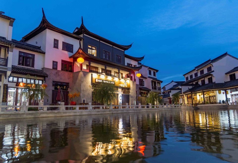
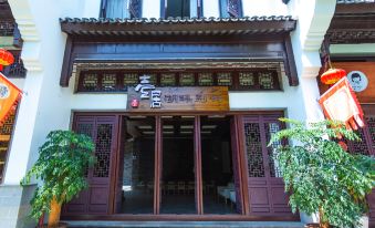
Yiju Lakeside Courtyard Hotel
0 nights
Rooms and Guests
1 room, 2 adults, 0 children
All Properties in Mile
Yiju Lakeside Courtyard Hotel
#17 of 4-star Select Hotels in Mile
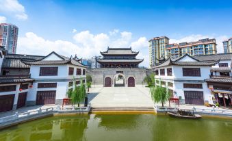
Honghe shuixiang tourist reception center, Mile, Yunnan, China
Show on Map
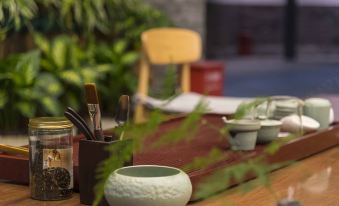
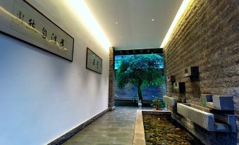
The Yiju Lakeside Courtyard Hotel provides a great place for travelers to relax after a busy day. The Yiju Lakeside Courtyard Hotel is an ideal choice for travelers who want to take in the sights and sounds of Mile. Show More
We Price Match
Last booked 13 hrs ago
4.7/5Amazing·Excellent Location
Antique and very clean
 Guest User
All 375 Reviews
Amenities
ParkingFreeRestaurantMulti-Function RoomLuggage StorageFree24-Hour Front DeskWi-Fi in Public AreasFree
All Amenities
Surroundings
Train: Mile Railway Station
(10.5 km)
Train: 竹园站
(40.3 km)
Landmarks: Qingdaozhapi Culture Square
(400m)
Map
Rooms
Guest Reviews
Policies
Services & Amenities

10
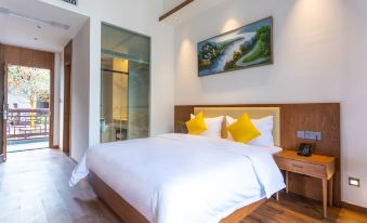
Loft - Lake-View (2 beds) (Balcony)
2 Queen bed
68m² | Floor: 3
Has window
Free Wi-Fi
Smoking Permitted
Air Conditioning
Private bathroom
Minibar
Tea Bag
Check Availability
9
Boutique 2-bed Room
2 Single bed
36m² | Floor: 2
Has window
Free Wi-Fi
Smoking Permitted
Air Conditioning
Private bathroom
Minibar
Tea Bag
Check Availability
8
Family Friendly Suite - with View (2 bathrooms, bathtub)
2 Queen bed
66-70m² | Floor: 3
May not have a window
Free Wi-Fi
Air Conditioning
Private bathroom
Minibar
Tea Bag
Check Availability
9
Double Loft
1 Queen bed
50m² | Floor: 2
Has window
Free Wi-Fi
Smoking Permitted
Air Conditioning
Private bathroom
Minibar
Tea Bag
Check Availability
7
Family Friendly Loft
1 Queen bed and 1 Single bed
50m² | Floor: 2
Has window
Free Wi-Fi
Smoking Permitted
Air Conditioning
Private bathroom
Minibar
Tea Bag
Check Availability
8
Family Suite - with View (Double bed) (2 bathrooms)
2 Queen bed and 1 Double bed
68-76m² | Floor: 3
Has window
Free Wi-Fi
Smoking Permitted
Air Conditioning
Private bathroom
Bathtub
Minibar
Check Availability
7
Deluxe Queen Room
1 Queen bed
35-40m² | Floor: 2
Has window
Free Wi-Fi
Smoking Permitted
Air Conditioning
Private bathroom
Bathtub
Minibar
Check Availability
7
Boutique Queen Room
1 Queen bed
30-48m² | Floor: 2
Has window
Free Wi-Fi
Smoking Permitted
Air Conditioning
Private bathroom
Minibar
Tea Bag
Check Availability
12
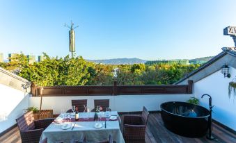
Deluxe Loft Suite - Lake-View (Terrace, bathtub)
1 Queen bed
68m² | Floor: 3
Has window
Free Wi-Fi
Smoking Permitted
Air Conditioning
Private bathroom
Bathtub
Minibar
Check Availability
Boutique Room - River-View (Double bed)
1 Queen bed
22m² | Floor: 2
Has window
Free Wi-Fi
Smoking Permitted
Air Conditioning
Private bathroom
Minibar
Tea Bag
Check Availability
Guestroom - Near River (Double bed)
1 Queen bed
42m² | Floor: 2
Has window
Free Wi-Fi
Smoking Permitted
Air Conditioning
Private bathroom
Minibar
Tea Bag
Check Availability
Hide Room Types
Guest Reviews(375)
4.7/5
Amazing
 Verified Reviews
- Cleanliness4.7
- Amenities4.6
- Location4.7
- Service4.7

Tong Aromsook
July 15, 2022
We stayed for one night at the hotel. The hotel is clean and have good and comfortable room. Nice services, simple and healthy breakfast. The hotel is located as part of new development area and near to a park. Recommend to visit the park in the morning or evening to see local people coming out to do activities.

Guest User
April 6, 2024
Facilities: None of the water facilities in the bathroom are easy to use. Water can spill everywhere. The balcony door is a wooden door with no sound insulation at all.
Hygiene: The pillowcase was dirty, so I contacted the front desk to have it changed. There were hair flakes on the floor.
Environment: The environment in the scenic spot is good. There is a bar next to the hotel, which is very noisy at night.
Original TextTranslation provided by Google

Arui��
December 6, 2023
Facilities: In the off-season, the occupancy rate was very low. I asked the front desk and said that I could upgrade the room type. This was originally a good thing. However, I found that the door lock was damaged and could not be locked in the middle of the night, so I had to move my things back to the original room in the middle of the night.
Service: Regarding the door lock issue, the staff replied: Our rooms are not locked (which is outrageous). When checking out, the boss was arrogant and only offered a "sincerity" for a discount next time. It was hard to accept. In the end, he gave the reason Ctrip processing ends.
Hygiene: There are foreign objects in the toilet, it is not clean, there are hairs and mosquitoes on the sheets
(There are few people in the off-season, so it is understandable that the room will be vacant for a long time, but it is unreasonable not to clean the room in advance when there is a reservation)
Environment: There is nothing wrong with the environment, but cars are not allowed in the park and there are no staff to pick you up. You have to carry your luggage and walk in and go up and down.
Original TextTranslation provided by Google

Anonymous User
August 8, 2023
I can ensure that it is a very objective evaluation.
1. The biggest drawback is the facilities. I took off my clothes and adjusted the water for more than ten or twenty minutes but still couldn't get the right warm water. Speaking of which, I stood in the bathroom and waited for nine minutes before I came. Then the little girl said that because of the recent weather... I interrupted her. When do you need to watch the weather for hot water when taking a shower? Why don't you charge according to the weather? Really speechless!
2. The quilt is dirty. The quilt cover is open at the end of the quilt, and yellow spots are exposed inside. It’s so disgusting.
3. Others: Very noisy, the door is covered with dust, and the bathroom drainage is not working...
All in all, it's full of flaws. I've booked a lot with Ctrip and rarely commented on it. This time it was too bad.
Original TextTranslation provided by Google

Tianzaodishewenchuang
July 30, 2021
The best hotel in Maitreya in my heart, climate
Mile City is located in the subtropical monsoon climate zone, with the highest elevation being 2315 meters in Dongshan Jinding Mountain and the lowest being 870 meters in the river valley. In 2012, the rainfall was 835.4 mm, the average temperature was 18.8°C, the highest temperature was 34.8°C, the lowest temperature was -0.2°C, the sunshine was 2131.4 hours, and the frost-free period was 323 days. Adequate sunlight, long effective temperature period, short frost and snow days. [1]
topography
The territory of Maitreya City is rich in mountains from east to west, the central part is low, and the terrain is high in the north and low in the south. Surrounded by mountains, a long and narrow flat dam and hilly area are formed. Mountains and rivers tend to move from north to south. The western stone mountains are rags with forested trees and shrubs; the surface of the eastern mountains is mostly weathered soil, covered with grass, shrubs and trees; there are valleys between the mountains, and the arable land is mostly scattered in the valleys and peace dams. The highest point is at Jinding Mountain to the east of Xinshao, with an elevation of about 2315 meters, and the lowest point is the exit of Nanpan River, with an elevation of about 862 meters. Very livable
Original TextTranslation provided by Google

Wenroudeyanjing
September 23, 2021
The hotel is very distinctive, with good service, clean, comfortable and close to the lake. Will visit again next time.
Original TextTranslation provided by Google
Guest User
September 23, 2021
Antique and very clean
Original TextTranslation provided by Google

Maomao��buku
March 28, 2024
✨剛從壹居·湖畔別院酒店回來,簡直要被它的魅力迷倒了!這家酒店位於美麗的紅河水鄉景區內,景色宜人,環境幽靜,讓人彷彿置身於人間仙境。🌈
🛌入住體驗超級舒適,房間寬敞明亮,裝修精緻典雅,每個細節都透露出品質生活的氣息。床鋪柔軟舒適,讓人一夜好眠。😴
👩🍳服務方面更是讚不絕口,員工們熱情周到,細緻入微的服務讓人倍感親切。無論是前台接待還是客房服務,都讓人感受到家的温暖。🏠
🌳此外,酒店的配套設施也非常齊全,健身房、游泳池、SPA等一應俱全,滿足了各種需求。交通也十分便利,周邊公交、自行車道、停車場等完善,出行無憂。🚗
💖總之,壹居·湖畔別院酒店是一家非常值得推薦的酒店,無論是度假休閑還是商務出差,都能讓你享受到舒適、便捷、高品質的住宿體驗。💯
Translate

Guest User
June 9, 2024
環境好,古色古香的味道,和朋友一起訂的五人間,附近有夜市有酒吧 ,吃東西方便,前台服務也很好,到的有點早,前台娜娜也讓我們提前住了,離店下雨,還幫我們延遲退房
Translate
Property Policies
Check-in and Check-out Times
Check-in: After 14:00
Check-out: Before 12:00
Front desk hours: 24/7
Guests Accepted
Guests from every country/region are accepted
Child Policies
Children of all ages are welcome at this property.
Children between 0 and 11 years old can stay for free if no extra bed is needed.
Cots and Extra Beds
For all room types, cots and extra beds cannot be added.
Breakfast
TypeChinese
StyleBuffet
Opening hours[Mon - Sun] 07:30-10:00 Open
| Age | Fee |
|---|---|
Adult | CNY 28.00 (approx. IDR 63,680) per person |
Additional breakfast fees are not included in the total and need to be paid at the property.
Show More
Property Description
- Opened: 2019
- Number of Rooms: 35
The Yiju Lakeside Courtyard Hotel provides a great place for travelers to relax after a busy day. The Yiju Lakeside Courtyard Hotel is an ideal choice for travelers who want to take in the sights and sounds of Mile.
From the hotel, Mile Railway Station is just 10km away. With multiple attractions nearby including Huquan Banshan Hot Springs, Yunnan Honghe Zhouhuquan Golf Club and Huquan Ecological Garden, guests will find plenty to keep themselves occupied.
In their spare time, guests can explore the hotel's surroundings. This Mile hotel features parking on site.
If you demand a high level of service, our guests have indicated that this hotel has excellent standards. This hotel is particularly popular with those traveling with families.
Services & Amenities
Most Popular Amenities
ParkingFree
Restaurant
Multi-Function Room
Luggage StorageFree
24-Hour Front Desk
Wi-Fi in Public AreasFree
Restaurant
Restaurant
Cuisine: Chinese
Show More